-
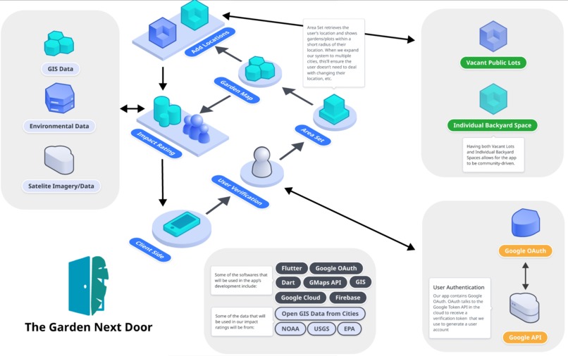
App Structure
-
App Mockups

Problem
Detroit faces a massive food insecurity problem with about 48% households facing food insecurity and 40% under the Food Stamps program. Many neighborhoods lack access to healthy and affordable produce in nearby grocery stores, leading to the creation of many food deserts within the city. To try to address this problem, many community-driven urban farms such as Detroit Black Community Food Security Network, are working to support Detroit’s largely Black low-income communities. There are reported to be over 1,400 community farms scattered throughout Detroit’s city proper. However, there are still many parts of Detroit’s metropolitan area that are underserved having little to no access to fresh food.
Detroit is also known to have one of the most vacant empty lots, a result of the city’s racist Urban Renewal plans in the ‘60s. According to Detroit Free Press, there are estimates of 20% to 40% of Detroit’s total square mileage that is vacant land. These vacant lots provide opportunities for existing Black-owned urban farms to serve the communities and branch out into neighborhoods that need it the most. We can remove some of the barriers of establishing community gardens in these vacant lots by giving people access to a database on where these lots lie and how to obtain the permit.
In addition, there are many landowners that have large amounts of backyard space that could be potential space for gardening. This will create a niche and opportunity to open up connections with people and allow them to create space for people to garden and share food that don’t have a backyard space of their own. Detroit continues to see an enormous increase in food security in its most vulnerable neighborhoods especially during the rise of Covid-19, giving ownership and empowerment to these communities through these vacant lots, as well as connecting neighbors and resource sharing with extra backyard space to be incredibly important.
Solution
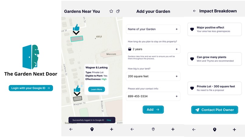
One of the ways that our app plans on solving the problem of a lack of space for community gardens in large cities like Detroit, is by connecting people with extra land they are not using with people looking to start a garden. In order to accomplish this, whenever a new person opens our app for the first time they will be asked to create an account by signing up with either their Google ID. Once their account has been created they will be directed to a screen where they can choose what they want their role to be, choosing from the following list of options: “gardener”, “host”, or “both”. If the user selects “host” or “both” they will be directed to a separate page to fill out a form with their address. Once completed, their address will appear as a pin icon (resembling a green thumb) on the app’s interactive map. When the icon is tapped on, it will show the contact information for users open to others using their land as a garden. If when signing up a new user selects “gardener” they will instead be directed directly to the interactive map where they can see where other users have listed their extra land, where existing community gardens are, and the best places for new community gardens.
We also plan to partner with a collective of urban farms such as D-Town Farm to build a database of vacant lots in Detroit where you can click on vacant lots and see what types of permits you would need to get, the steps to obtaining that lot, and to how to get in with the right people to purchase or obtain the lot. This section will be more of an internal tool with existing urban farm community organizations. Vacant lots will have information that’s readily available on who owns this parcel as well as the sale price. This will help local community organizations prioritize which lots to develop in order to serve the larger population.
Vacant lots will have scores and information on:
- How manageable it is to propose a community garden there
- How much it will serve the surrounding community
- Environmental impacts
- What plants will be able to grow and survive there
- Potential mitigation on pollution
Feasibility
Our project has high technical feasibility because of relatively low start-up costs and easy implementation. The app is easy to develop based on currently available maps and datasets for the given area in which we plan to do our initial release. The positive environmental impact will be assessed based on the Environmental Benefit Index (EBI) from the U.S. EPA. The data needed to analyze the environmental impact of a certain location will be derived from currently-existing databases like GIS maps, NOAA, U.S. Geological Survey, U.S. Fish and Wildlife Service, USGS WaterWatch websites, and satellite images. Data on empty land parcels are available through Detroit Land Bank. Other information such as space areas, length of ownership, and time period for donation can be gathered from the private space donator.
Our app also has an easy-to-use and intuitive user interface. Private land-owners who wish to allow other users to use their land will simply fill out a form with their information, and a pin on the interactive near their property. EBI values of their donated space will also be showcased on the interactive map, as well as how to contact the landowner. These results are highly interpretable as they are scored indexes, and will become handy tools for residents to see how much of a positive impact a garden can have in their area. The interactive map will also showcase potential areas where new community gardens can be started and prioritized based on index scores on environmental and community impact. Different potential areas will have different indexed scores so that users can determine where the best places to develop a community garden would be. This is a very important part of our app and another one of the unique features about our app as it will allow community members to allocate resources to the most beneficial areas, and can help communities justify their gardens when facing resistance from real estate developers and lobbyists.
The only major financial input of this project would be centered around developing, publishing, promoting, and maintaining the mobile app. However, it will require no investments for physical construction or data collection, which are two of the major cost complications associated with other solutions. Based on these characteristics, we believe that this project will be financially feasible. Our app brings benefits to all stakeholders. Major users of our app include private landowners who donate their space, community members who seek open green spaces, and local urban farms who are looking for both farming space and potential clients.
Targeted Audience and Benefits
By using our app, private landowners can retrofit their yards and acquire sustainable water and/or food supply. Existing local urban farms can easily find open lots for their activities. And by establishing their farms inside of neighborhoods, they spread their reach and impact. In addition to gardens, community members can form strong bonds and understand more about where their food comes from and get connected with local urban farms. Sites of gardens are selected to bring optimal environmental impacts based on available spots, and are selected by local residents. The biggest benefit for the environment lies in the decentralized nature of these gardens as green infrastructures, as well as the optimized choice of location. Vacant lots vary in ownership, and the legalities of ownership are tenuous. While the Detroit Land Bank Authority was established to help alleviate difficulties of permits and legalities of obtaining these vacant lots, there has been some criticism on how they prioritize certain groups, especially higher-income groups, over others. Our app naturally targets the underserved and local organizations in Detroit by offering more affordable green spaces. By connecting landowners and the neighborhood, we also offer opportunities outside of Detroit’s lot permit system.
Potential Difficulties
Differences may arise on how long these private gardens will be donated, or what is allowed on their property. We respect the needs of both community members and the private landowners. We invite the place donor to explicitly lay out mutual expectations for the garden on their property, including the expected length of donation. The host will formally consent on the access of their gardens and allowed activities to the community members. We also verify the ownership of the donated private land before they appear on the interactive map to avoid possible legal problems. Another one of the main issues for almost any app when it is first released is trying to get people to download and begin using it, and our app is no different. However, to address this problem we have chosen existing organizations trying to start community gardens as our target audience. We have chosen this specific audience for our app because these people are already looking to start community gardens, but may just have difficulty figuring out what the next steps are. Our app would be greatly beneficial to these organizations as it would have all the relevant information they need to start a community garden, as well as where the best place to put them in order to maximize the positive effects on the community.
Another difficulty we foresee is data and timeline maintenance. We plan to run processes of space donation, index evaluation, and construction annually. We will collaborate with other grassroots organizations and local governments, and regularly visit our source databases to keep our information updated.
What's Next for Garden Next Door
The Garden Next Door has the potential to help food insecure populations outside of Detroit. We’ve methodically planned out our roadmap for future development.
Community Input: It starts with working with our target user base. We want to talk to community leaders and members in our target cities to better understand their needs beyond the research papers and third-party information. This discussion ensures the creation of a tool that is sculpted by and for the communities it serves.
Mobile App Development: Once we complete this stage, we will commence our mobile app development. We want to ensure a user experience that is intuitive, to the point, and scalable. This scalability allows us to create unique experiences for our different communities. This will be followed up with a companion web version of our product that broadens our user base beyond smartphone usage and allows for additional features.
After intensive testing, we plan on rolling out to our target cities (starting with Detroit and then Houston, Stockton, and New Orleans) which we believe would most benefit from our project.
Built With
- figma


Log in or sign up for Devpost to join the conversation.