-
-
frontend
-
node setup

Project Overview
TerrAIn is an environmental monitoring system designed to optimize sustainable agriculture and land management. It deploys a decentralized network of intelligent sensor nodes, each capable of capturing real-time environmental metrics alongside precise geospatial data. The platform addresses critical challenges such as inefficient water use, delayed fire detection, and soil health degradation by enabling continuous monitoring and actionable analysis. Beyond agricultural applications, TerrAIn extends its utility to disaster prevention, resource management, and ecological research. The modular architecture supports flexible deployment across varied terrains, from farmland to forested regions, enhancing scalability and adaptability.
Technical Architecture
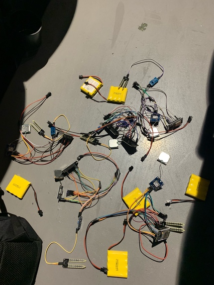
The TerrAIn system is structured as a distributed mesh network where each sensor node functions as an independent data acquisition unit. The hardware layer is based on ESP-32 microcontrollers integrated with digital temperature sensors, capacitive soil moisture sensors, and precision barometric pressure sensors, alongside u-blox GPS modules for continuous position tracking. Each node executes custom firmware responsible for data polling, preprocessing, and wireless communication using the painlessMesh library to establish a self-healing, decentralized network topology. Sensor data is aggregated at edge nodes and relayed via MQTT over Wi-Fi to AWS IoT Core, which serves as the centralized broker for incoming telemetry streams.
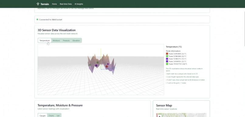
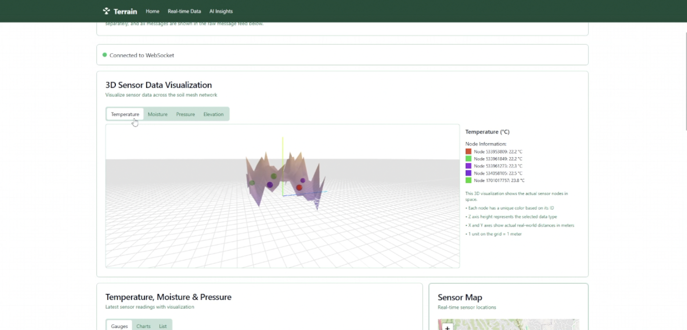
On the server side, incoming MQTT payloads are processed through an optimized backend for 3D visualizations. A machine learning analytics layer, powered by Google Gemini APIs, further processes the data to derive predictive insights such as anomaly detection, irrigation scheduling, and early-stage fire risk indicators. The visualization layer consists of a React-based dashboard interfaced with WebSocket streams for real-time updates, integrated with 3D scene for volumetric environmental visualization, and map-based plotting for geospatial data exploration.
Development Process
Development was structured through a modular division of responsibilities to maximize efficiency and maintain system cohesion. Firmware development, managed by Ben, focused on low-level sensor integration, mesh networking reliability, and optimization of communication protocols under constrained hardware resources. Server-side infrastructure, including MQTT ingestion, scalable data storage, and AI pipeline development, was led by Andy. Frontend development was a collaborative effort between Ben and Andy, involving real-time data visualization, 3D rendering integration, and seamless backend interfacing through secure WebSocket endpoints.
Technical Challenges
Several significant technical challenges were encountered and systematically addressed during development. One major obstacle was the limited hardware resources of the ESP-32, particularly the contention between Bluetooth and Wi-Fi modules required for mesh networking, which necessitated firmware-level resource arbitration and stack optimization. GPS performance presented another challenge; achieving fast and reliable satellite acquisition required careful tuning of UART buffer sizes and GPS polling rates.
Maintaining robust MQTT connections under intermittent connectivity conditions demanded custom retry and buffering mechanisms at the firmware level, as well as server-side idempotency to handle potential duplicate messages. Version control complexity grew as parallel firmware, server, and frontend development introduced tight coupling between system layers.
Achievements
The project successfully delivered a live, operational sensor mesh capable of resilient, real-time environmental data collection across a distributed geographical area. It established a scalable backend capable of ingesting and processing thousands of telemetry events per minute with minimal latency. The visualization dashboard supports real-time geospatial and volumetric data representation, allowing users to intuitively analyze environmental conditions as they evolve. Furthermore, the analytics pipeline, powered by machine learning models, lays the groundwork for predictive alerting and prescriptive agricultural recommendations.
These achievements collectively demonstrate the feasibility of decentralized, intelligent environmental monitoring systems for large-scale deployments, opening pathways for future commercial applications.
Lessons Learned
Key lessons from TerrAIn’s development emphasize the necessity of containerized environments to decouple software dependencies and ensure cross-platform reproducibility. Hardware development demands continuous iteration, aggressive validation under real-world conditions, and a tolerance for hardware failures and field anomalies. Additionally, real-time distributed system development requires not only robust code but also resilient communication protocols and disciplined version control practices. Cross-functional collaboration between firmware, backend, and frontend teams proved essential to achieving tight integration across system layers, validating the importance of synchronized sprint cycles and continuous integration pipelines.
Future Development Roadmap
Future development plans for TerrAIn focus on enhancing system intelligence, resilience, and scalability. Upcoming work includes the integration of supervised and unsupervised machine learning models to enable predictive analytics such as crop disease forecasting and autonomous irrigation recommendations. Satellite imaging data fusion is planned to provide multi-scale environmental insights, improving the accuracy and granularity of land use monitoring. Solar-powered sensor nodes will be developed to eliminate dependency on battery replacement and facilitate long-term unattended deployments. Additionally, custom PCB design will replace off-the-shelf development boards to reduce hardware costs and size, while enterprise-grade cloud infrastructure improvements, including serverless computing and horizontal scaling strategies, will prepare the system for commercialization and mass deployment. Business intelligence modules will be introduced to provide stakeholders with actionable reports and automated decision-making tools based on the collected environmental data.
Built With
- amazon-dynamodb
- amazon-web-services
- c/c++
- ec2
- flask
- gemini
- iot
- mqtt
- python
- react

Log in or sign up for Devpost to join the conversation.