Inspiration
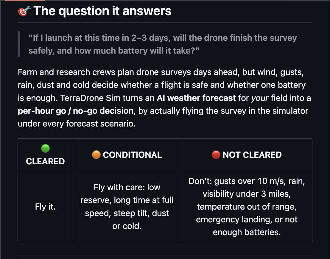
Farm and agricultural research crews plan aerial surveys days in advance, always asking the same critical question: "If I launch at this time in 2–3 days, will the drone finish the survey safely, and how much battery will it take?"
Traditional weather apps only provide raw numbers like wind speed or temperature, leaving operators to guess how a sudden gust front, blowing dust, or cold-air density drop will actually impact a multispectral quadrotor flying a tight grid over a potato trial or cherry orchard. We were inspired to bridge this gap between AI weather forecasting and rigid-body flight dynamics. Instead of relying on static rules of thumb, we built a flight lab that takes high-resolution ensemble forecasts for a specific field and actually flies the survey in simulation across every forecast hour and scenario before the crew ever leaves the ground.
What it does
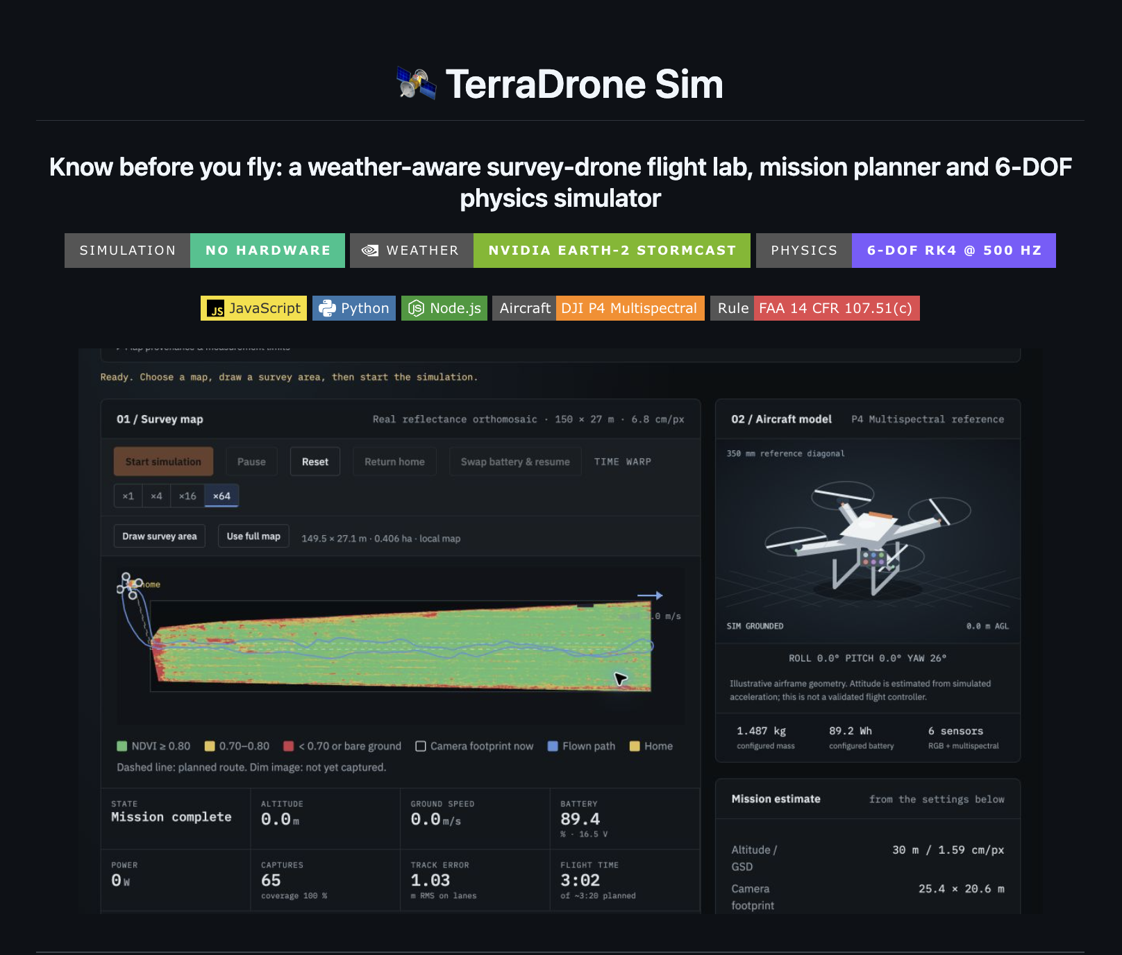
TERRADRONE-SIM is a weather-aware survey-drone flight lab, mission planner, and 6-DOF physics simulator modeled around the DJI P4 Multispectral and FAA 14 CFR 107.51(c) regulations.
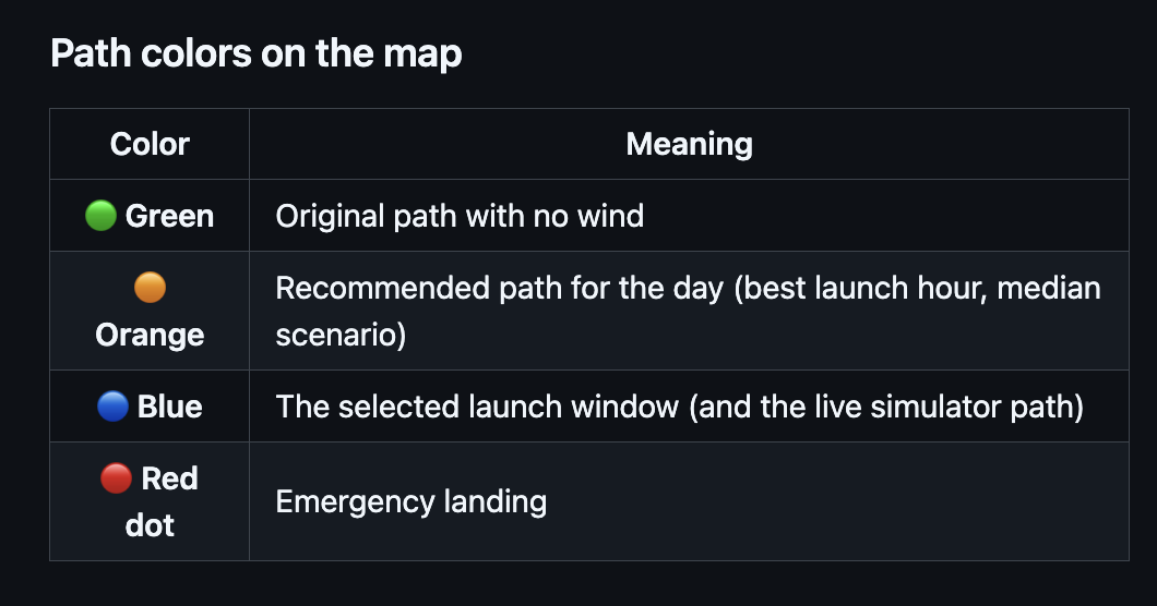
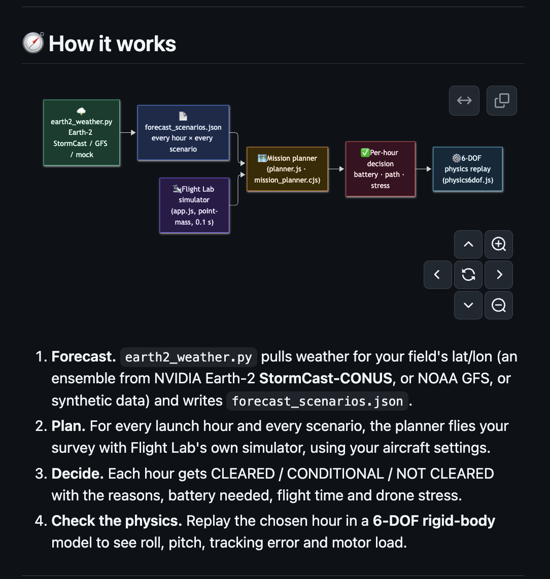
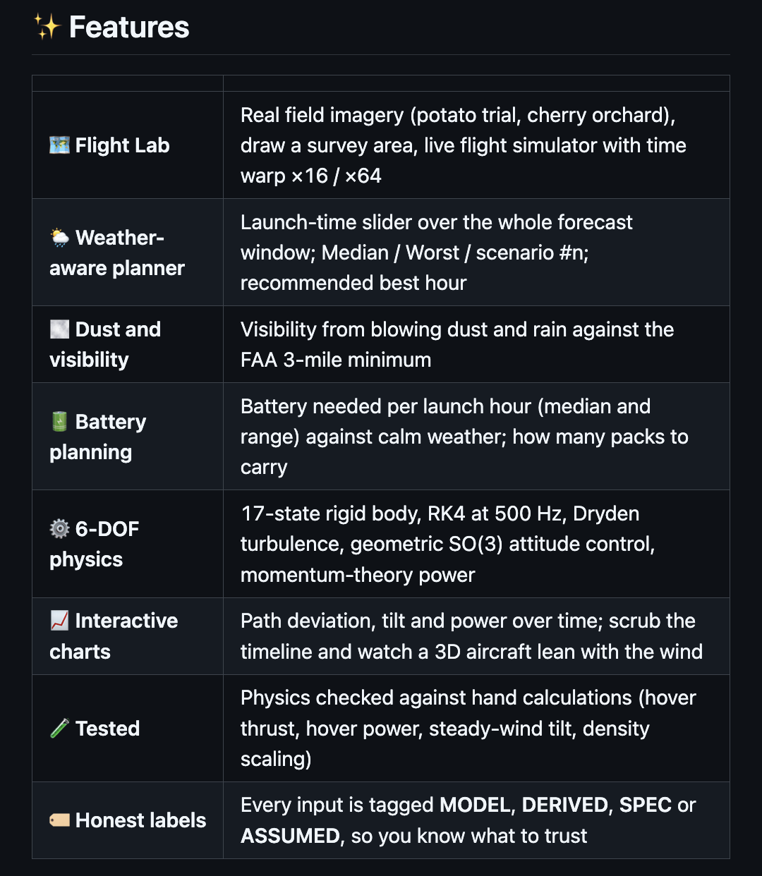
It pulls hourly ensemble forecasts for a field's exact latitude and longitude using NVIDIA Earth-2 StormCast-CONUS (a 3 km high-resolution AI ensemble steered by NOAA GFS), standard NOAA GFS, or synthetic storm fronts. For every launch hour and ensemble scenario, the planner flies a custom-drawn survey grid using our point-mass simulator to evaluate flight time, battery consumption, pack count, and airframe stress. It then outputs an actionable CLEARED, CONDITIONAL, or NOT CLEARED verdict against 10 m/s gust limits, precipitation (>0.5 mm/h), FAA 3-statute-mile (4.8 km) visibility minimums, cold-weather battery derating, and emergency landings. Finally, it replays the selected launch window in a 500 Hz, 17-state rigid-body simulator to compare calm-air baselines against wind-perturbed trajectories, analyzing roll/pitch tilt, cross-track error, and individual rotor power draw.
How we built it
We architected TERRADRONE-SIM as a modular pipeline connecting Python-based AI weather ingestion with a zero-dependency browser and Node.js simulation engine.
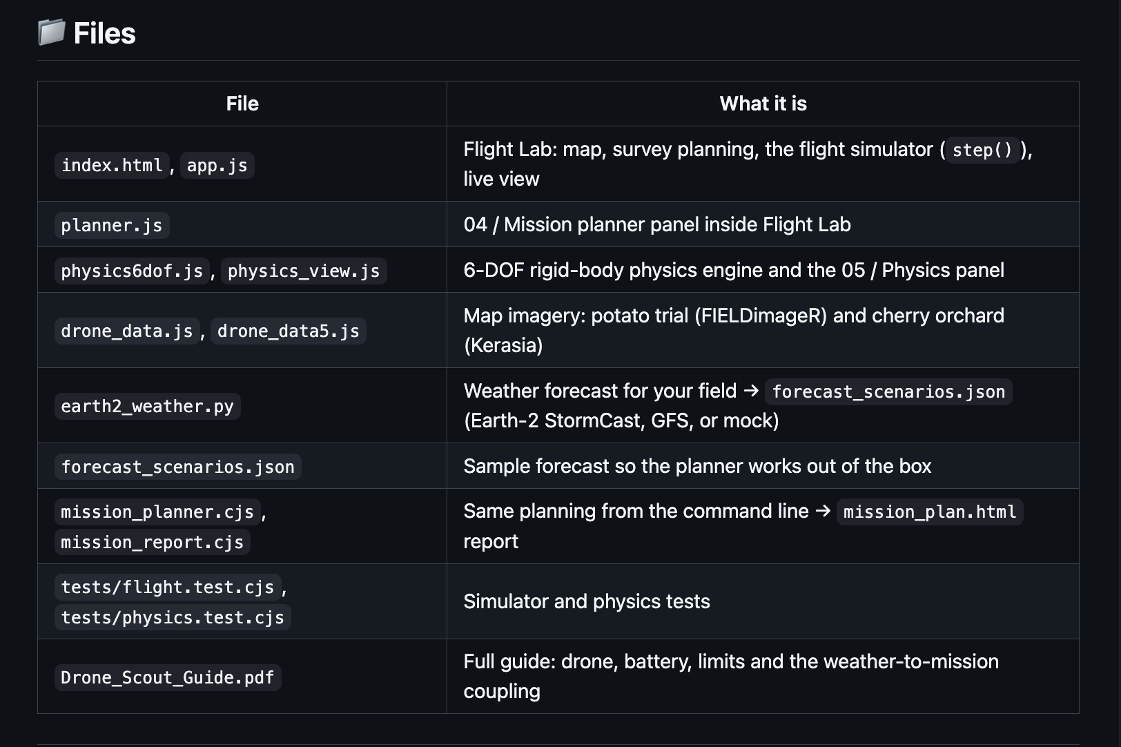
Our weather pipeline (earth2_weather.py) uses earth2studio to run NVIDIA Earth-2 StormCast-CONUS and fetch NOAA GFS data, compiling hourly multi-scenario ensembles into forecast_scenarios.json. We translated these meteorological outputs into flight boundary conditions by scaling 10-meter winds to flight altitude z via a power-law boundary layer profile and deriving gust magnitudes from mean wind U and ensemble spread σ:
- Altitude Wind Profile:
U(z) = U₁₀ · (z / 10)^0.14 - Ensemble Gust Magnitude:
U_gust = √((0.15 · U)² + σ²)
We also modeled light extinction from blowing dust and rainfall to estimate flight visibility against the 4.8 km FAA minimum, and applied temperature-driven battery capacity derating at -0.75% per °C below 20°C.
For the interactive Flight Lab and headless CLI planner (app.js, planner.js, mission_planner.cjs), we built a deterministic 0.1 s point-mass simulator that runs identically in the browser with 16x / 64x time-warp and in Node.js to generate standalone mission_plan.html reports. To validate the chosen launch window, we built a 17-state 6-DOF physics engine (physics6dof.js) integrated via 4th-order Runge-Kutta (RK4) at 500 Hz. The state vector tracks 3D position p, velocity v, attitude quaternion q, body angular rates ω, and four first-order motor thrust states Tᵢ, governed by the following equations of motion:
- Position & Velocity:
ṗ = vandv̇ = (R(q)·[0, 0, ΣTᵢ] + F_drag(v − w)) / m − g - Attitude & Body Rates:
q̇ = ½ q ⊗ [0, ω]andω̇ = J⁻¹(τ − ω × Jω) - Motor Dynamics:
Ṫᵢ = (Tᵢ,cmd − Tᵢ) / τ_motor
The aircraft is flown by a cascaded controller featuring route guidance, a wind-learning velocity PI loop, a 35° tilt-limited thrust vector mapper, and geometric attitude control on SO(3) feeding an X-quad mixer under Dryden low-altitude turbulence (MIL-HDBK-1797) and GNSS noise. Electrical power per rotor is computed via momentum theory and scaled by local air density ρ:
- Rotor Power & Density Scaling:
Pᵢ ∝ Tᵢ^1.5 / √(2ρA)andP_hover(ρ) = P_hover,0 · √(1.225 / ρ)
Challenges we ran into
Our biggest challenge was balancing simulation speed against physical fidelity. Running a 500 Hz 17-state RK4 simulation across 8 launch hours and multiple ensemble members directly in the browser would take minutes of compute time and stall the UI. We solved this by designing a two-tier architecture where our fast 0.1 s point-mass simulator sweeps the entire forecast matrix in seconds, while the 500 Hz 6-DOF engine runs on-demand to validate the chosen window against calm and median baselines.
Another major challenge was modeling realistic wind coupling without "cheating." Because a real autopilot does not directly know the ambient wind vector, we designed our flight controller to estimate wind from the discrepancy between ground velocity and airspeed using a 3 s time constant. This naturally reproduced how sudden gusts and turns push the drone off its survey track and exposed how standard calm-air return-to-home calculations can deplete battery reserves mid-return under strong headwinds.
Accomplishments that we're proud of
We are especially proud of the close physical agreement between our two simulation tiers and our commitment to scientific transparency. Under an 8 m/s crosswind, our fast point-mass simulator predicts a 14.4° steady-wind lean angle compared to 13.9° in the full 17-state 6-DOF engine, and our entire physics core is verified via automated test suites (tests/physics.test.cjs and tests/flight.test.cjs) against analytical hand calculations for hover thrust, hover power, steady-wind tilt, and air-density scaling. Furthermore, rather than hiding assumptions inside a black box, we explicitly audited and tagged every single parameter in our UI and codebase as MODEL, DERIVED, SPEC, or ASSUMED so operators know exactly what to trust. We also built the JavaScript simulation engine with zero external dependencies, allowing the exact same step() loop to power both the interactive 3D web canvas and the headless Node.js batch planner.
What we learned
Through building TERRADRONE-SIM, we learned how to operationalize NVIDIA Earth-2 StormCast high-resolution mesoscale ensembles into downstream robotics and mission-planning tools. We gained deep practical insight into how atmospheric thermodynamics—specifically temperature, barometric pressure, and humidity—alter air density ρ and measurably shift multirotor hover power and multi-battery survey logistics. On the flight dynamics side, we saw firsthand the mathematical elegance of geometric attitude control on SO(3) paired with quaternion kinematics, which completely avoids gimbal lock and handles aggressive turbulent gust recovery smoothly.
What's next for TERRADRONE-SIM
Next, we plan to expand from a single forecast grid cell per field to spatially varying 3D wind fields paired with Digital Elevation Model (DEM) terrain-following for sloped orchards and valleys. We also want to implement wind-optimal route re-planning that automatically rotates survey sweep angles to align with forecast wind vectors, minimizing crosswind crabbing and turn-around energy penalties. Finally, we aim to add direct MAVLink and QGroundControl export so operators can take weather-cleared, 6-DOF-validated mission plans and export them directly to .plan and .waypoints formats for immediate field deployment.


Log in or sign up for Devpost to join the conversation.