-
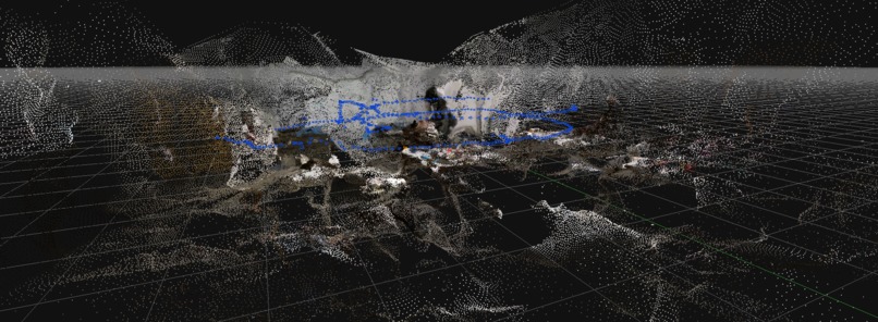
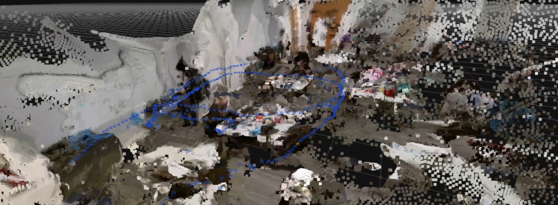
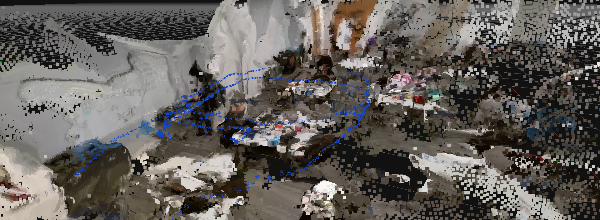
Resulting 3D reconstruction from the image data collected using our custom DJI Tello control and recording software.
-

TelloExplore 🤖
Inspiration ⚡
Perchance, my dear friends, upon a resplendent morn, we pondered the unfathomable depths of the unknown. In the spirit of those brilliant minds who came before us, we ventured to craft a contraption to plumb the depths of perilous and mysterious territories. With the soul of exploration alit within us, we devised the concept of TelloExplore, a marvel for the intrepid adventurer and the cautious scholar alike.
What it does 🚀📸
TelloExplore, a remarkable contrivance, grants mankind the ability to venture into treacherous environments whilst maintaining a safe distance. The ingenious mechanism employs a Tello drone to gather invaluable information, which is then transformed into a resplendent, high-resolution 3D map by employing the latest in photogrammetry and structure from motion techniques. From the bowels of the deep sea to the infinite expanses of space, this technological wonder allows our species to plan expeditions and operations with unerring accuracy, ensuring that humanity may continue to unravel the mysteries of the unknown without incurring unnecessary risk.
How we built it 🚧⚒️
Our noble endeavor began with the acquisition of a Tello drone, a delightful flying apparatus that we married with the power of low-level C programming. Through this union, we created a high-performance data-gathering pipeline, capturing the raw essence of our surroundings. Once in possession of this invaluable data, we then imported it into a GPU-accelerated photogrammetry and structure from motion package 3DF Zephyr, generating vivid, high-resolution 3D maps that bring to life the uncharted landscapes that once lay shrouded in mystery.
We used GitHub as a data synchronization server for large quantities of JPEG-compressed H264 decoded video frames from the DJI Tello and resulting 3D models coming from our photogrammetry library. In ordinary situations, such drastic measures would never have been taken, but the expedience of the option was too tempting to ignore.
Challenges we ran into 🧱
As with any great undertaking, our path was fraught with obstacles. The challenge of interfacing our Tello drone with low-level C programming required considerable fortitude, and we found ourselves grappling with the intricacies of such an arcane language. Additionally, the maintenance of a strong and reliable radio connection that minimized h264 video packet loss was a challenge, as we endeavored to ensure the utmost accuracy in our data collection.
Moreover, the integration of GPU-accelerated photogrammetry and structure from motion algorithms was not without its tribulations. Fine-tuning these complex computations to produce the most faithful and intricate 3D maps demanded the full measure of our intellectual prowess and determination.
Accomplishments that we're proud of 🏅🏆
Despite the arduous journey we undertook, we are proud to have surmounted these challenges and emerged victorious. Our creation, TelloExplore, stands as a testament to our ingenuity and tenacity. We have successfully harnessed the power of technology to transcend the boundaries of human exploration, allowing us to delve into hitherto uncharted territories with precision and safety.
We are also deeply gratified by the potential for TelloExplore to benefit humanity in times of dire need, such as natural disasters or nuclear reactor failures, where the technology may serve as an indispensable tool for gathering data to aid in planning and conducting rescue operations.
What we learned 🧠🏋️
In the course of our grand endeavor, we have gleaned precious insights into the art of drone programming and the intricacies of GPU-accelerated photogrammetry and structure from motion. We have come to appreciate the importance of perseverance and collaboration in surmounting challenges and the immeasurable rewards that await those who dare to dream and innovate.
What's next for TelloExplore 🌒 The future of TelloExplore gleams bright, as we continue our quest to refine and expand our knowledge of creating safe and reliable robotic systems augmented by advanced data processing packages. While, for this effort, data was manually gathered and post-processed into valuable 3D maps, advances in cloud computational capacity and artificial intelligence may let us see the day when such advanced maps can be generated in real-time. Real-time generation from low-cost cameras and vehicle sensors would enable advanced automatic mapping of complex environments with unprecedented safety and resilience to radio communications failures.
In the spirit of collaboration and the betterment of humankind, we shall work tirelessly to ensure that TelloExplore remains a strong and simple software base for controlling the low-cost DJI Tello hardware, illuminating the path for upcoming generations of brave souls who seek to unravel the mysteries of the unknown by the sharp instrument of robotics.


Log in or sign up for Devpost to join the conversation.