-
-
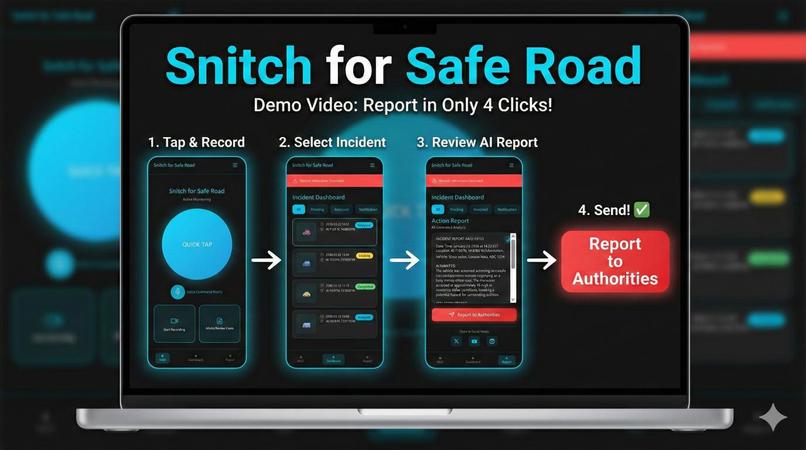
Report in 4 clicks
-
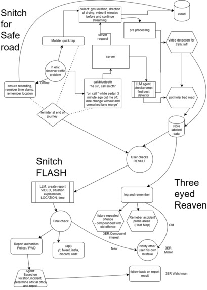
Base Idea
-
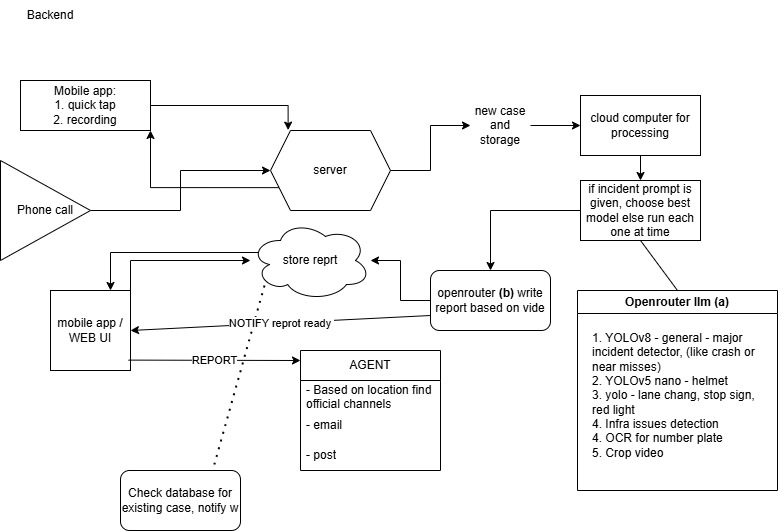
Backend
-
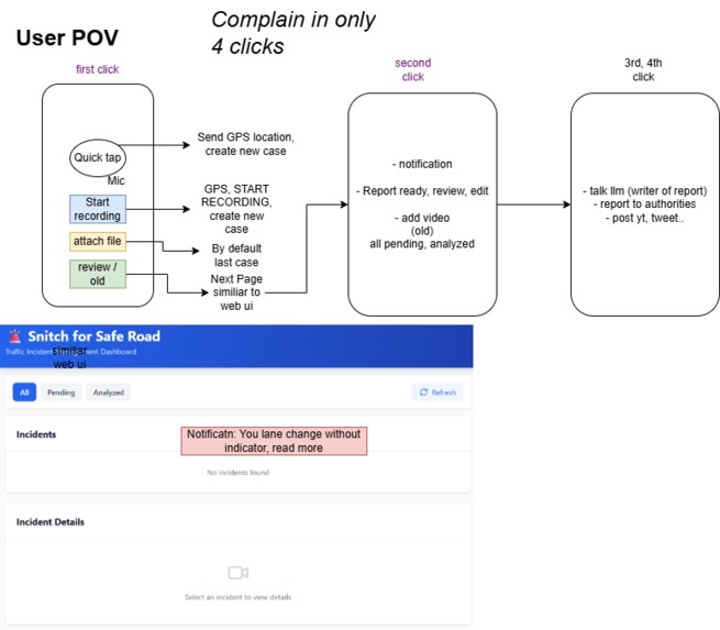
USER POV


Inspiration
Personal experience reporting the sudden appearance of a 4-5 feet deep hole on road side, likely caused by electrical maintenance work. However, this maintenance damaged water pipes, and the water department damaged the LAN line. Throughout this entire ordeal of 3 weeks, the hole remained open, and not a single department took responsibility fill it back. After a week of mail exchange, I used AI agent to deal with the bureaucracy, but the agent soon broke because official emails (provided by the state government) to some officers were deactivated due to inactivity. I ended up posting my entire journey on YouTube, X (Twitter), Instagram, Discord, fb and WhatsApp groups which finally fix it.
During this experience, I also discovered that the RTO (Traffic Police) of every city uses different platforms (apps and websites) for damage reports. If you're not a direct victim, there's no easy way to file a report, use their given platforms.
What it does
Snitch for Safe Road is a citizen-first reporting assistant that enables anyone to quickly report dangerous road issues—Bad Drivers, such as potholes, open trenches, broken traffic signals, waterlogging, and missing manhole covers. It guides users through a flow, collects photos, location information, and a brief description, then automatically formats and routes the complaint to the appropriate authority (RTO/traffic police, municipal corporation, water board, etc.) for that specific city. The tool also tracks the status of submitted reports and aggregates them on a map so that patterns of negligence or recurring problem areas can be highlighted for both citizens and officials.
How we built it
We built Snitch for Safe Road as a lightweight web application with a conversational interface that walks users through the reporting process step by step. The backend processes photos, GPS/location data, and text, then uses simple rules and city-specific configurations to determine which authority (RTO, traffic police, municipal body, water board, etc.) should receive the report. We integrated email and API-based dispatch so the system automatically generates a properly formatted complaint and sends it to the mapped official channels, storing each case with a unique ID for follow-up. The map view and dashboard pull from this stored data to display hotspots, recurring problem regions, and the status of reports (pending vs. resolved).
Challenges we ran into
The primary challenge was navigating the complex reality of Indian civic reporting: every city and department uses different apps, forms, and email addresses, and many "official" contacts are outdated or inactive. Designing a generic data model that could handle different issue types, cities, and authorities without hardcoding every edge case proved difficult. Additionally, we had to balance gathering enough information to create a useful report while keeping the chat flow brief enough that users would complete it on mobile networks and low-end devices.
Accomplishments we're proud of
We successfully converted a frustrating real-life experience—dealing with a dangerous open hole and poor coordination between departments—into a concrete tool that ordinary citizens can use. Creating a single chat-based interface that conceals the complexity of multiple government systems while still generating actionable, well-routed complaints felt like a significant achievement. We are also proud of our early mapping and aggregation features, which demonstrate how individual "small" complaints can reveal systemic road-safety risks when visualized together.
