-
-

Front demo
-

User-frendly Website
-
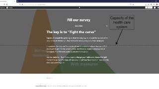
Website pt.2
-

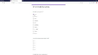
Quick and easy survey
-

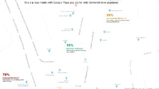
Real-time interactive map (demo)


Idea
My idea was to use GPS data from our smartphone, in order to evaluate the risk of going in a specific place, like the grocery store or to the pharmacy. In fact, avoid huge number of people in the same place at the same time is crucial to prevent the outbreak. The idea was basically a "google maps" that we use to avoid traffic, but this case to avoid crowds.
The idea then opened to a quick and easy survey in order to give the opportunity to citizens a first look at the habits of people in their own city. In fact, this will help them schedule their day in a smart way and selecting the right time to go out.
Inspiration
We have been inspired from the situation and problems in Italy, where we live. In order to enter into the grocery store, or pharmacy, it usually takes 1-2 hours, with a large number of people gathering outside. During a pandemic, this situation can be very risky and should be taken seriously.
What it does
Smart Mobilety is an idea that ideally aims to create a perfect logistic organization for people movements by choosing the ideal moment for every single one to go out. One of the strong points of the project is that people will basically create the schedule on their own, leaving plenty of space for us to work on data and feature implementation.
What is next for Smart Mobilety
Smart Mobilety has a bright future in front of it, it is open to multiple addition and features, it will grow and expand the web of people connected to it making the data and statistics always bigger and more reliable and it opens to a ton of new uses and applications.
What we learned
We had a really good time this week end and we learned that quarantine can be fun
Accomplishments that we're proud of
We are really proud of our idea and the project we have created in these few days. I really hope you can enjoy it and appreciate our work.
Built With
- google-services
- microsoft-services
- photoshop
- premiere


Log in or sign up for Devpost to join the conversation.