-
-
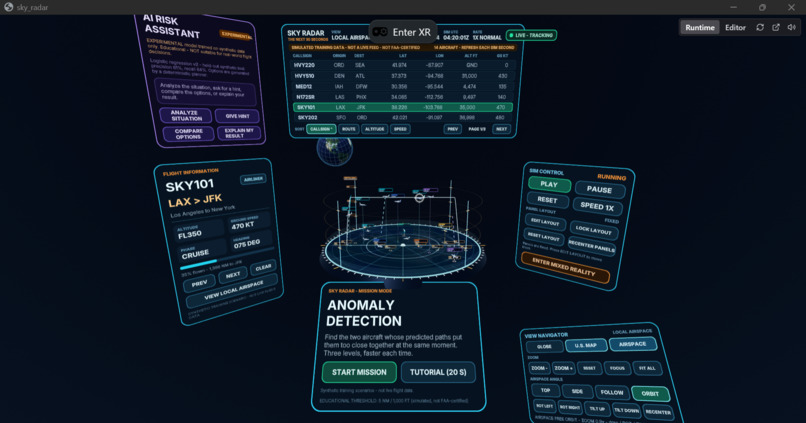
Visualize aircraft at different altitudes, examine projected flight paths, and identify potential conflicts in a 3D airspace.
-
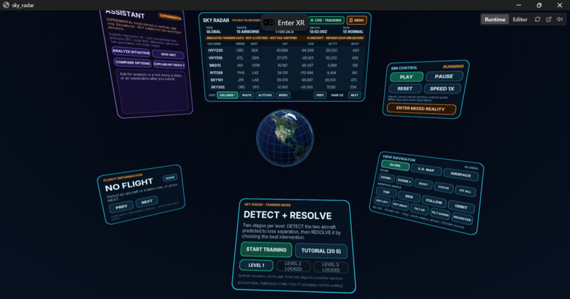
Sky Radar's immersive training environment challenges users to detect potential aircraft conflicts and evaluate safer trajectories.
Inspiration
On November 13, 2026, just days before our hackathon presentation, the FAA issued a nationwide ground stop after technical disruptions affected air-traffic communications and radar systems.
In January 2025, a devastating midair collision near Washington, D.C., claimed 67 lives, highlighting the importance of airspace safety, situational awareness, and risk management.
Although these incidents had very different causes, they reinforced a question that inspired our project:
What if we could make complex aviation data easier to understand, help people recognize potential conflicts earlier, and provide an immersive environment to practice making safer decisions?
That question led us to build Sky Radar: The Next 30 Seconds.
Our vision is to make aviation safety training more interactive, accessible, and data-driven through mixed reality and artificial intelligence.
What it does
Sky Radar is an AI-assisted mixed-reality air-traffic training simulator that challenges users to identify potential aircraft conflicts and evaluate possible interventions.
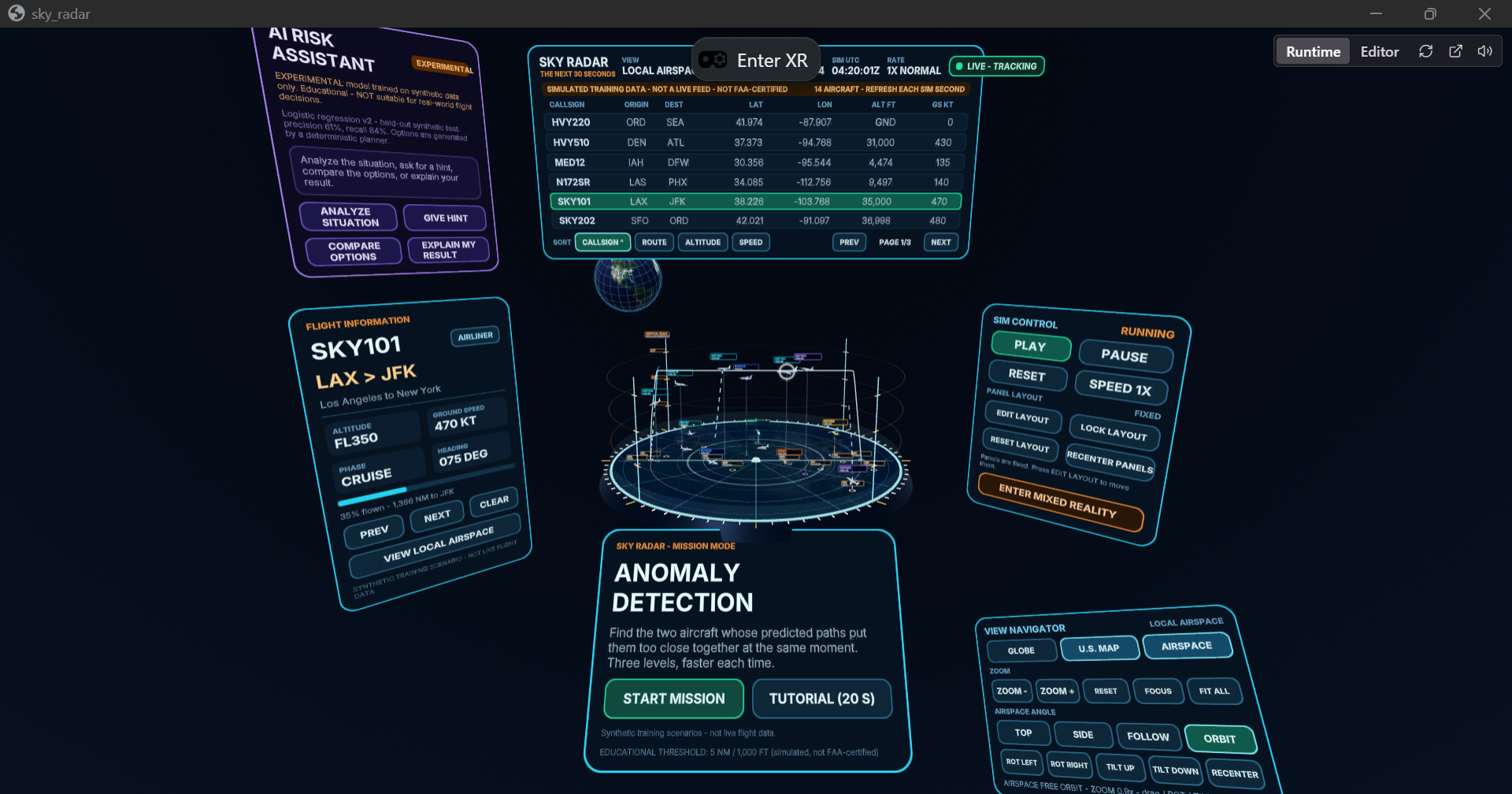
Using the Meta Quest 3S, trainees can explore a simulated U.S. airspace environment through three perspectives:
- Globe View: Explore aircraft routes across a 3D Earth.
- U.S. View: Monitor domestic flights on a geographical map.
- Airspace View: Examine aircraft positions, altitudes, and trajectories in an immersive 3D environment.
Each aircraft is associated with simulated flight information, including its origin, destination, latitude, longitude, altitude, speed, and timestamp.
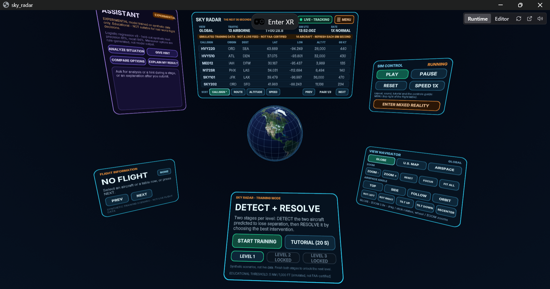
Training consists of two stages:
Stage 1 — Anomaly Detection: Trainees have limited time to analyze the flight data and identify two aircraft approaching a predicted loss of separation.
Stage 2 — Conflict Resolution: Trainees evaluate AI-assisted maneuver suggestions, select an intervention, and observe how the proposed flight trajectories affect the simulated outcome.
As trainees advance through levels, traffic density increases and decision-making becomes more challenging.
Sky Radar combines visualization, data interpretation, and human decision-making into one interactive learning experience.
How we built it
We developed Sky Radar using a combination of immersive technology, 3D visualization tools, artificial intelligence, and modern web development frameworks.
Our technology stack includes:
- Meta Quest 3S: For immersive mixed-reality interaction and spatial exploration.
- Three.js: For rendering interactive aircraft, geographic environments, and animated flight trajectories in the browser.
- Unity: For supplementary 3D visualization, prototyping, and exploring spatial representations of aircraft movements.
- Meta Immersive Web SDK and WebXR: For XR interactions, spatial interfaces, and headset compatibility.
- TypeScript: For simulation logic, interactive controls, aircraft movement, and application state management.
- Artificial Intelligence: An experimental machine-learning risk assistant trained on synthetic aviation scenarios to support anomaly analysis and educational feedback.
- Claude Code and OpenAI Codex: For AI-assisted software development, debugging, and implementation.
- Cloudflare Pages: For deployment and hosting during development and testing.
Our simulation uses synthetic flight scenarios, geographic coordinates, projected trajectories, and separation calculations to create educational conflict-detection challenges.
We designed the application to connect flight data with spatial visualization, allowing trainees to examine aircraft movements and make informed decisions rather than relying solely on automatic alerts.
Challenges we ran into
Building a mixed-reality aviation training application under hackathon time constraints presented several challenges.
XR development and compatibility: We had to develop a browser-based 3D application while learning the development tools and maintaining compatibility with the Quest 3S.
Development environment issues: We encountered Windows IWSDK runtime errors that prevented our local development server from launching. We worked around these issues by validating production builds and deploying through Cloudflare.
Geographic visualization: Transforming aircraft positions between a 3D globe, a flat U.S. map, and a local airspace view required careful handling of coordinates, scaling, and camera positioning.
Flight trajectory realism: We worked to move beyond decorative flight paths by incorporating different altitudes, flight phases, and more realistic-looking trajectories.
User experience: Presenting detailed flight information, AI suggestions, and training controls in an immersive environment without overwhelming the trainee required several rounds of UI refinement.
These challenges pushed us to balance technical complexity with accessibility and practical usability.
Accomplishments that we're proud of
We are especially proud of turning an ambitious idea into an interactive XR training prototype within a limited hackathon timeframe.
Our accomplishments include:
- Building a U.S.-focused, immersive air-traffic visualization.
- Connecting simulated aircraft movements with flight-data displays.
- Creating interactive anomaly-detection challenges with increasing difficulty.
- Developing a two-stage training experience that combines risk identification and decision-making.
- Integrating experimental AI assistance into the training experience.
- Creating multiple spatial perspectives for understanding aircraft movement.
- Developing a browser-based XR application that can be deployed and accessed without a traditional native app installation.
Most importantly, we developed something that goes beyond displaying flight information: an experience where users can actively explore aviation data, identify potential risks, and learn from their decisions.
What we learned
One of our biggest lessons was that visualizing data is not the same as understanding it.
Two aircraft trajectories may appear to intersect when viewed from above, but that doesn't necessarily mean the aircraft will come dangerously close. Their altitudes, positions, and timing all matter.
We also learned that AI is most valuable when it supports human reasoning rather than replacing it.
Our goal became not simply to tell trainees which aircraft might conflict, but to help them understand why a potential conflict exists and how different interventions can change the predicted outcome.
Through this project, we gained experience in mixed-reality development, 3D visualization, simulation design, AI integration, and human-centered interface design.
What's next for Sky Radar: The Next 30 Seconds
We see Sky Radar as an early prototype of a larger immersive aviation education platform.
Future development could include:
- More sophisticated aircraft trajectory and anomaly prediction models.
- Larger and more diverse air-traffic scenarios.
- Additional training scenarios involving weather, altitude deviations, and unexpected route changes.
- Improved explainable AI for evaluating potential interventions.
- Instructor dashboards and trainee performance analytics.
- More realistic aviation data and simulation environments.
- Collaboration with aviation educators and subject-matter experts to evaluate the training experience.
Sky Radar currently uses synthetic data and simplified simulation assumptions. It is not an operational ATC tool or FAA-certified safety system.
Our long-term vision is to explore how immersive technology and AI can help make aviation education more engaging, understandable, and accessible.
"Sky Radar: See the risk. Understand the data. Change the outcome."
Source Code: GitHub repository — https://github.com/AGKidanemariam/sky-radar
The repository will provide the project source code and instructions for setting up and running Sky Radar locally.
Built With
- 3s
- artificial
- claude
- cloudflare
- code
- codex
- github
- immersive
- intelligence
- javascript
- learning
- machine
- meta
- openai
- pages
- quest
- sdk
- three.js
- typescript
- unity
- vite
- web
- webxr
