-
-
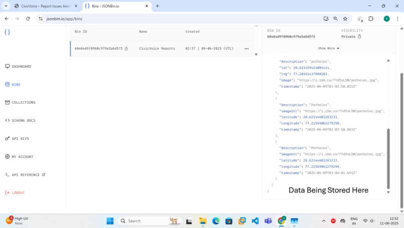
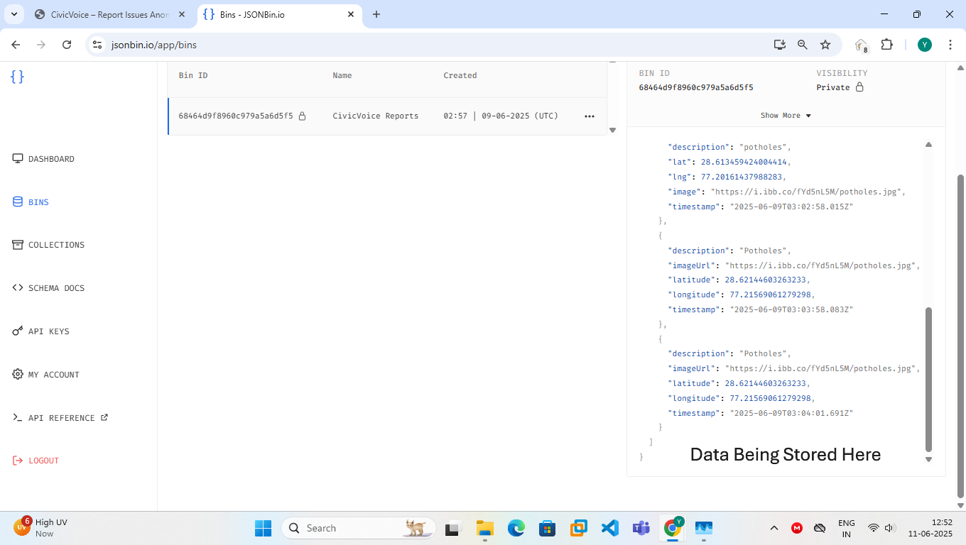
The Data Being Stored here.
-
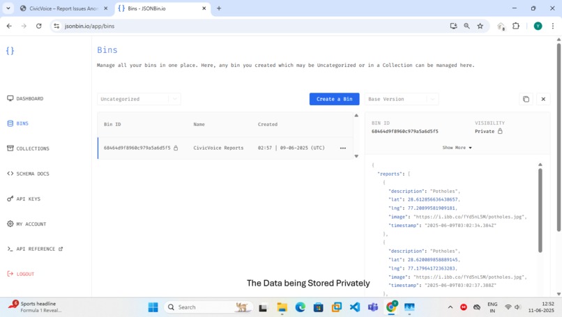
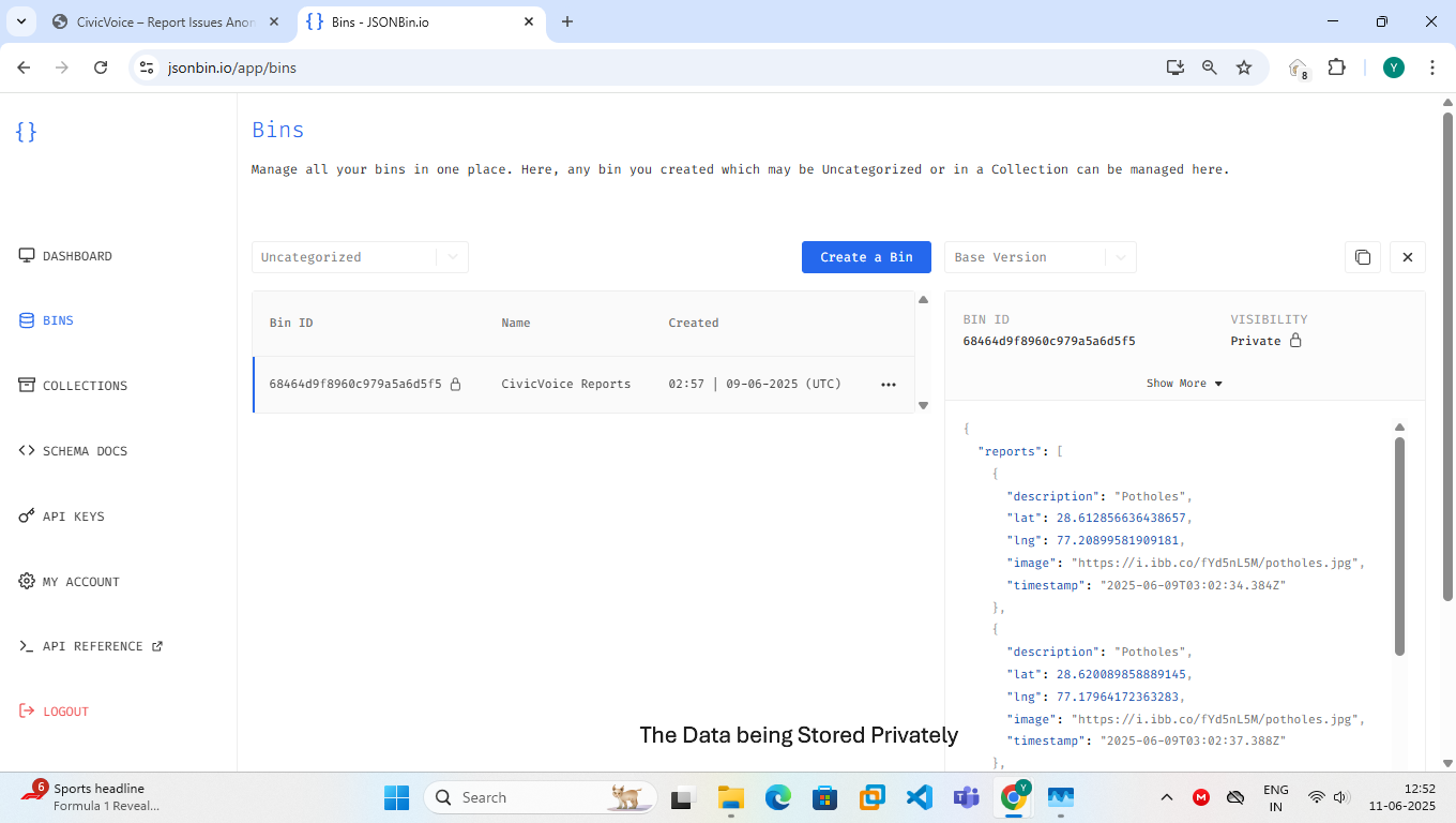
The Data Stored here.
-
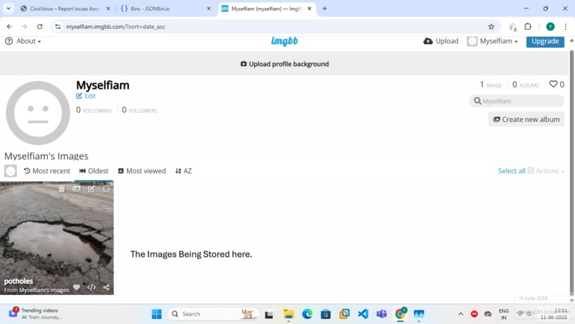
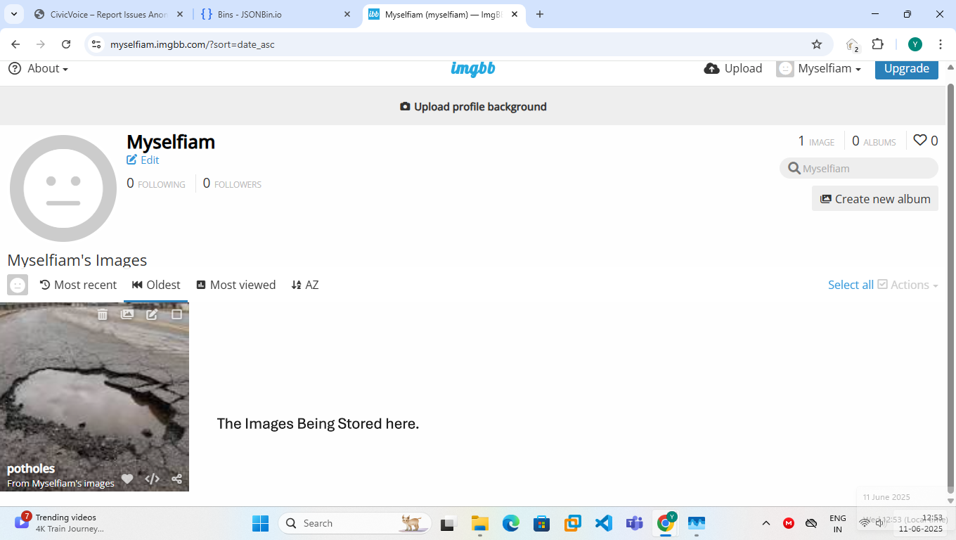
The Images Being Stored Here.
-
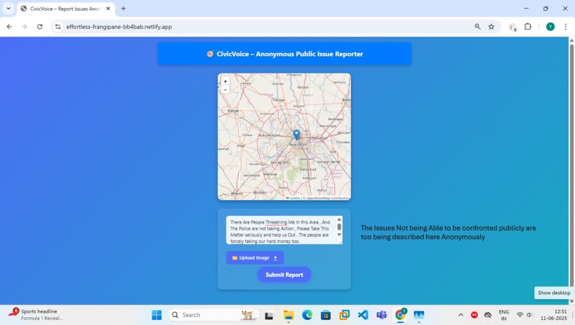
Big Crimes Which Cannot Be told To anyone Can also Be Highlighted here Anonymously here Without any Fear
-
The Issue Not reached to Municipality Can be Highlighted here anonymously without the fear of getting exposed .

Inspiration
In a world where voicing local issues can sometimes come with fear, bias, or inaction, many citizens remain silent about problems in their surroundings—be it broken roads, overflowing garbage, or unsafe areas. We were inspired by this silence.
SilentSignal was born from the idea that every citizen should have the power to report problems without fear—anonymously, quickly, and with proof. We aimed to bridge the gap between unheard voices and local authorities, with a clean, intuitive, and secure interface powered by geolocation and strong privacy.
“Real change begins when people can speak freely, even when they choose not to speak out loud.”
What it does
SilentSignal is a privacy-first civic engagement platform that enables users to:
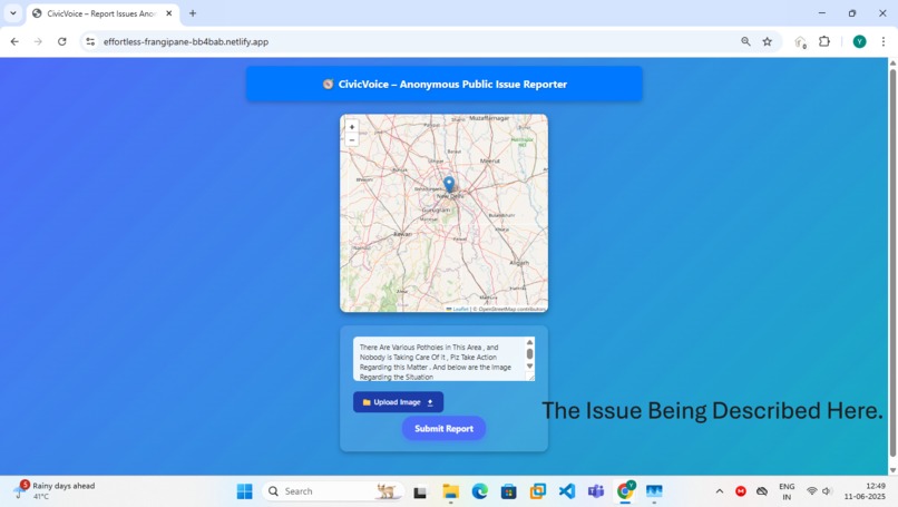
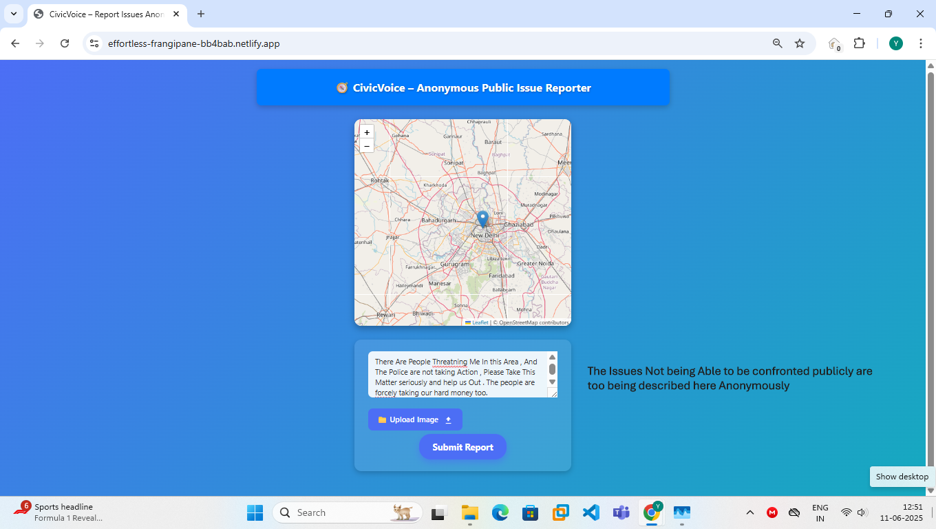
📍 Report issues anonymously by clicking on a live map (powered by Leaflet and OpenStreetMap).
📝 Submit detailed descriptions of local problems — potholes, trash, unsafe locations, etc.
📸 Upload photo evidence to support reports.
📌 Auto-tag reports with coordinates, allowing civic authorities or volunteers to see issue hotspots.
🧭 View recent issues and community contributions through interactive galleries and data sections.
🔒 Protect user identity completely — no login, no email, no personal data collected.
🌍 Encourage transparency through publicly visible submissions with timestamp and location.
The platform makes civic reporting feel like second nature — quick, elegant, and private.
How we built it
We built SilentSignal as a privacy-first civic reporting platform using accessible and minimal technology:
🌐 Frontend: HTML5 + Basic CSS: We kept the interface simple and accessible to prioritize functionality and clarity over visual complexity.
Leaflet.js + OpenStreetMap: This allowed us to build an interactive map where users can select the location of the issue.
Vanilla JavaScript: Used to manage image previews, map interactions, and form validation without relying on large frameworks.
🔙 Backend: JSONBin.io API: A quick and anonymous backend service for storing reports submitted by users. It requires no login, database setup, or cost, making it perfect for MVPs and prototypes.
🔐 Privacy-First Philosophy: No signups or logins: Users can report issues without providing any personal information.
No cookies, no tracking: We intentionally kept the site tracker-free to build user trust.
Anonymous Submissions: Reports include just the description, image, coordinates, and timestamp.
By using minimal tools and focusing on privacy and usability, we created a powerful tool that works across devices and gets the job done with zero bloat.
Challenges we ran into
Building SilentSignal with minimal tools was a strategic decision, but it came with its own set of unique challenges:
🔄 Real-time Map Integration Without Complex Backend We had to find a way to capture and store geolocation data (latitude and longitude) in real-time using just Leaflet.js and store it in a way that could later be visualized or filtered — all without a traditional backend or database. Getting this right required trial and error, especially with ensuring correct formatting and submission to JSONBin.
🖼️ Secure & Seamless Image Upload
We wanted users to upload images of issues anonymously. Balancing previewing images, preventing bad uploads, and sending them with reports (while keeping the system lightweight) was a major challenge. We had to rely on client-side preview with tags and careful FileReader usage, while future-proofing it for integrations like ImgBB or Firebase.
⚠️ Form Validation + UX Without Libraries Without using Bootstrap, React, or even jQuery, we had to build the entire form validation, error handling, and feedback system using plain HTML and JavaScript. Making sure users couldn’t submit empty reports or forget to click the map took time and testing.
🔐 Privacy by Design, Not by Accident Making a privacy-first tool meant we had to avoid third-party trackers, analytics, and login systems, even when some would have made implementation easier. This required extra caution with every library or CDN script we considered.
🧪 Debugging Without DevOps Tools Without a backend console, logging server-side issues wasn’t an option. We had to rely on browser dev tools, console.log(), and manual API response checks to troubleshoot issues like failed form submissions or wrong JSON formatting.
Despite these hurdles, overcoming them helped us create something more thoughtful, lightweight, and impactful.
Accomplishments that we're proud of
Despite the constraints of using only lightweight tools and working without a full backend, we achieved several milestones that made SilentSignal a powerful proof of concept:
✅ A Fully Functional Anonymous Reporting System We created a working system where:
Users can pinpoint locations on an interactive map.
Describe civic issues anonymously.
Upload photographic evidence.
Submit everything without revealing personal data — all stored safely via JSONBin.
🌍 Geo-Tagged Reports Without Google Maps By integrating Leaflet.js and OpenStreetMap, we enabled detailed map-based submissions without relying on paid APIs or compromising privacy. It's fully open-source and free for anyone to use.
🧠 A Clean, Intuitive UX with No Frameworks Despite not using any frontend frameworks, we built a modern, responsive user interface that feels professional and easy to use — all using vanilla HTML, CSS, and JS.
🔐 Privacy-First Design from Day One We’re proud that everything — from map clicks to image uploads — works without requiring login, cookies, or user tracking, making this tool truly anonymous and privacy-preserving.
💡 Scalable Design While currently lightweight, the system is designed to scale. In the future, it could plug into:
Firebase or other DBs for richer analytics.
Municipal dashboards.
SMS/email alerts to local authorities.
What we learned
Building SilentSignal was not just about coding — it was a full-circle experience in solving a real-world problem using ethical technology. Here’s what we learned:
🧠 Designing for Privacy Is Challenging — but Possible We learned how difficult it is to build useful systems without invading privacy. But through:
Client-side only implementation,
No user accounts, and
Anonymous data submission, we proved it’s possible to balance civic utility with user protection.
🗺️ Open Source Tools Are Underrated We explored powerful tools like:
Leaflet.js for mapping,
OpenStreetMap for tiles,
JSONBin for lightweight backend storage — and realized that you don’t need fancy tools to build powerful applications.
🧪 UX and UI Matter More Than We Thought A major takeaway: people won't use even the best tech unless it's visually clear, intuitive, and fast. We spent time refining:
Button interactions,
Floating labels,
Image previews,
And real-time validation — which significantly improved usability.
⚙️ Simplicity Can Scale By keeping the architecture minimal (HTML + CSS + JS + JSONBin), we created a deployable MVP in a short time, ready to be extended later.
What's next for SilentSignal
SilentSignal is just getting started — we designed it as a privacy-first MVP, but we’re already planning its evolution into a powerful civic empowerment platform.
🧩 Upcoming Features Real-time Heatmaps Visualize frequently reported issues by region — help authorities prioritize based on data density.
AI-Powered Issue Categorization Use NLP to automatically tag reports like “pothole,” “garbage,” “streetlight,” “waterlogging” etc., making filtering and response faster.
Decentralized Storage (IPFS Integration) Move image evidence to IPFS for tamper-proof, censorship-resistant data hosting.
Multi-language Support Add support for major Indian regional languages to improve accessibility.
Offline Mode with Sync Let users record a complaint offline — sync automatically when they reconnect.
🤝 Community Collaboration Partnering with local municipal bodies to pilot the system.
Open-sourcing the code for student volunteers, NGOs, and local developers to contribute and replicate it city-wise.
Launching a volunteer responder dashboard — let communities step up even before the government does.
💡 Long-Term Vision We aim to create a nationally federated system, where every city has its own SilentSignal instance, reporting into one unified public database.
Imagine a crowd-verified public health + safety map — powered by anonymous citizen data, and free from surveillance.
Built With
- hmtl
- jsonbins
- leaflet.js


Log in or sign up for Devpost to join the conversation.