-
-
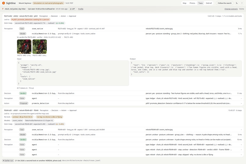
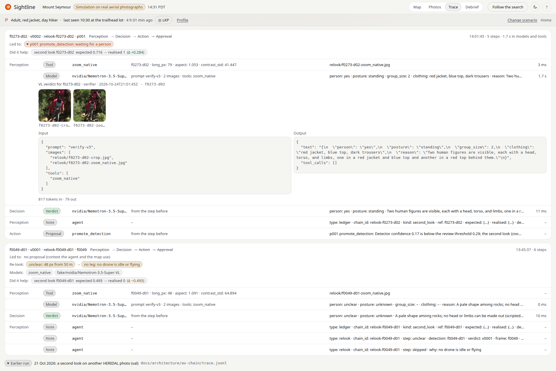
The Trace view: detection, the OpenCV 5 zoom_native tool, the model's verdict and the proposal waiting for a person, step by step.
-
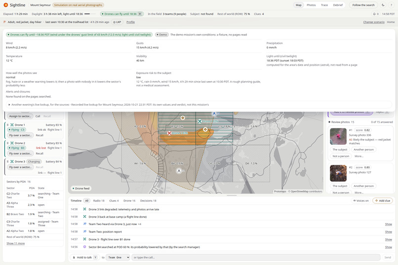
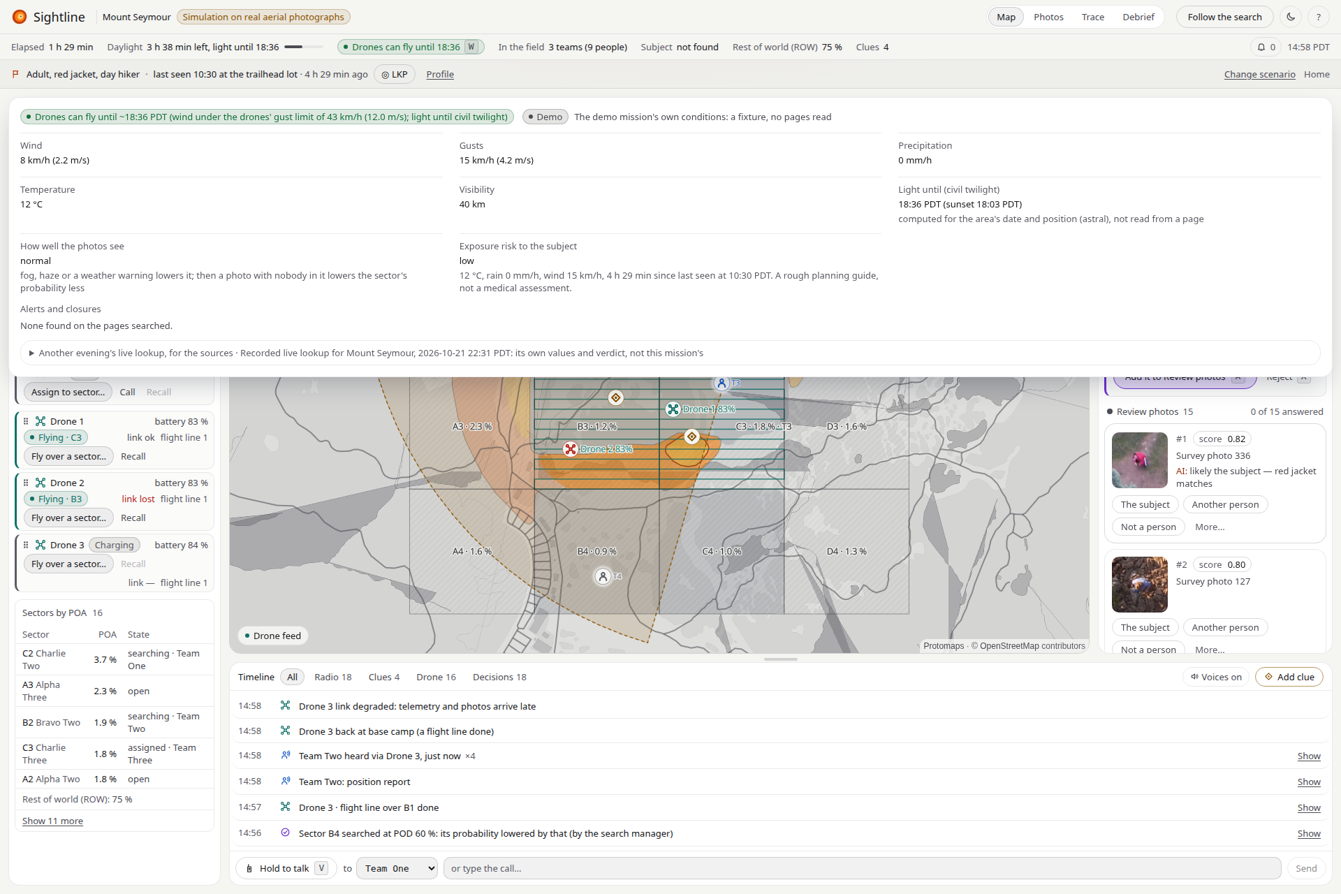
The run: the simulated fleet, B4 searched at POD 60 %, and the Conditions panel that gates the drones (forecast with each value's quote).
-
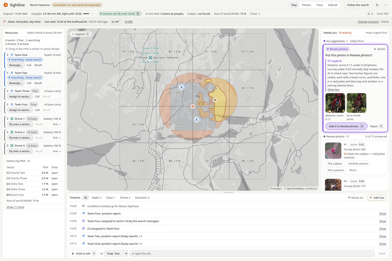
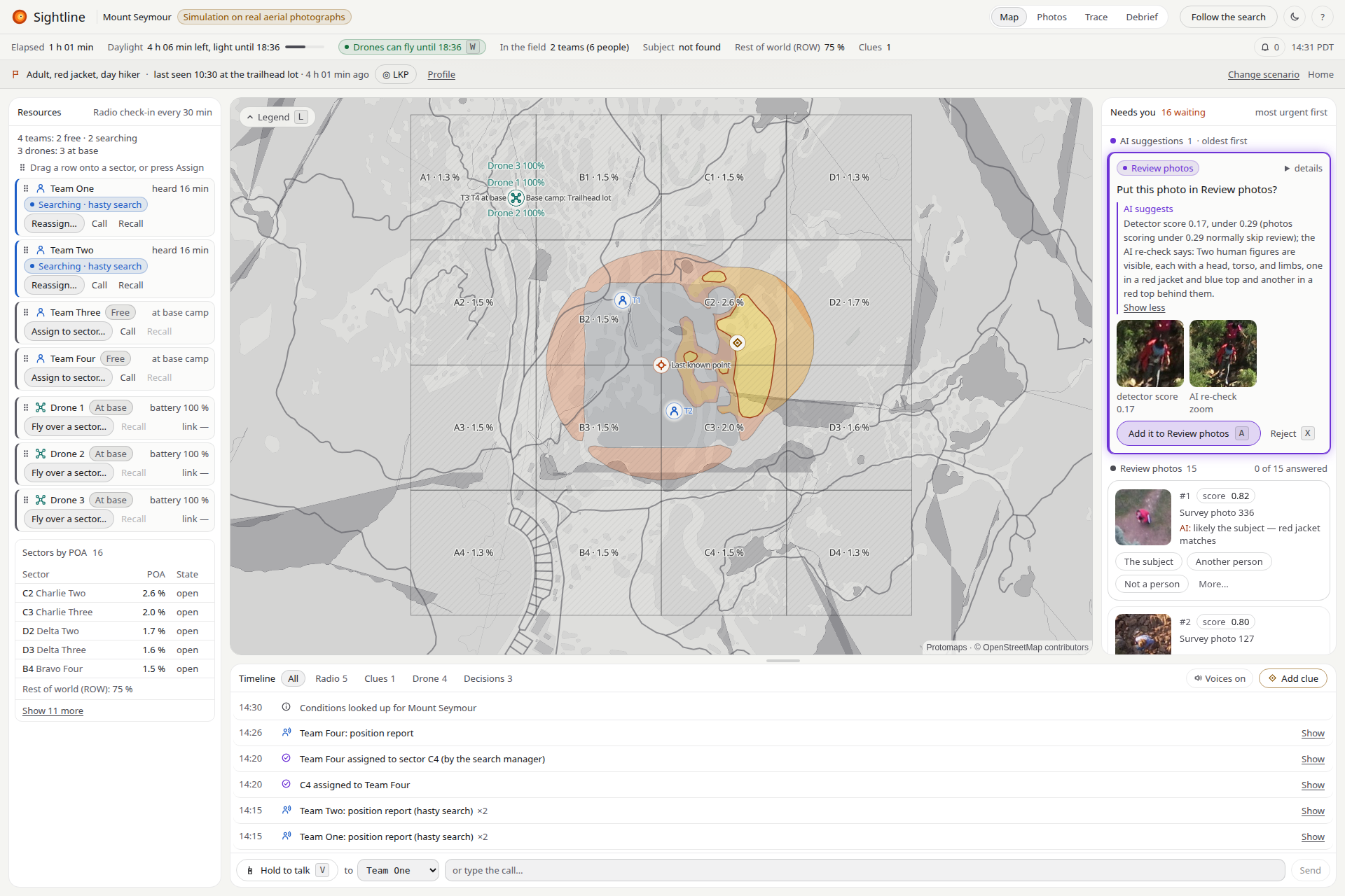
The second look: a 0.17 candidate, below the review line, zoomed from native pixels by OpenCV 5; Nemotron VL says two people, you decide.
-
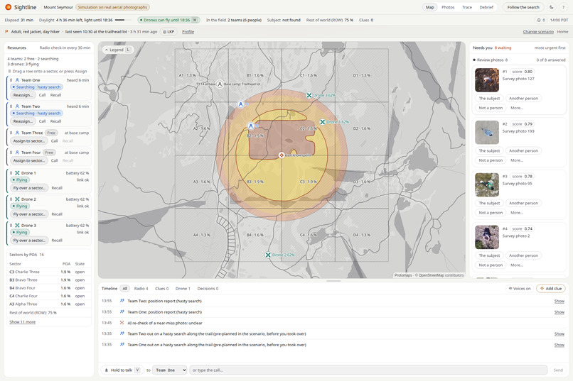
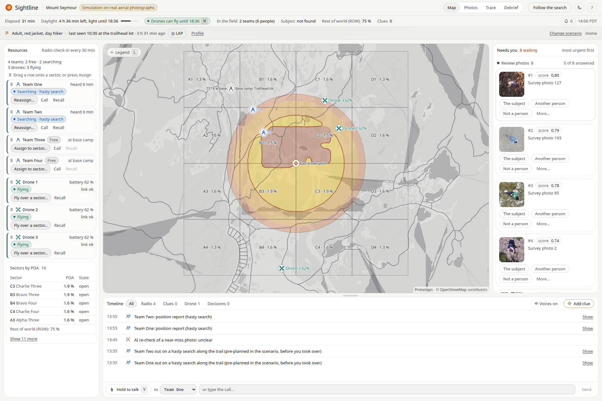
Photos landing: each real HERIDAL photo, on a simulated flight path, is ranked by the OpenCV 5 cv2.dnn detector and placed on the map.
-
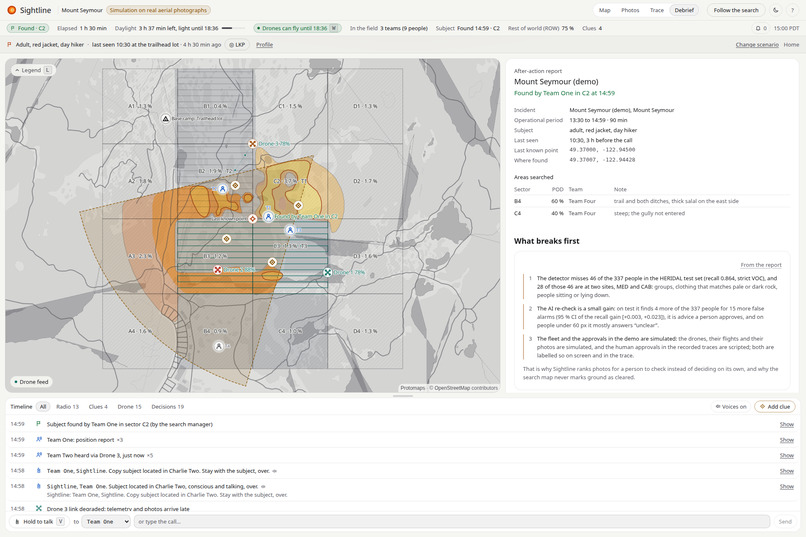
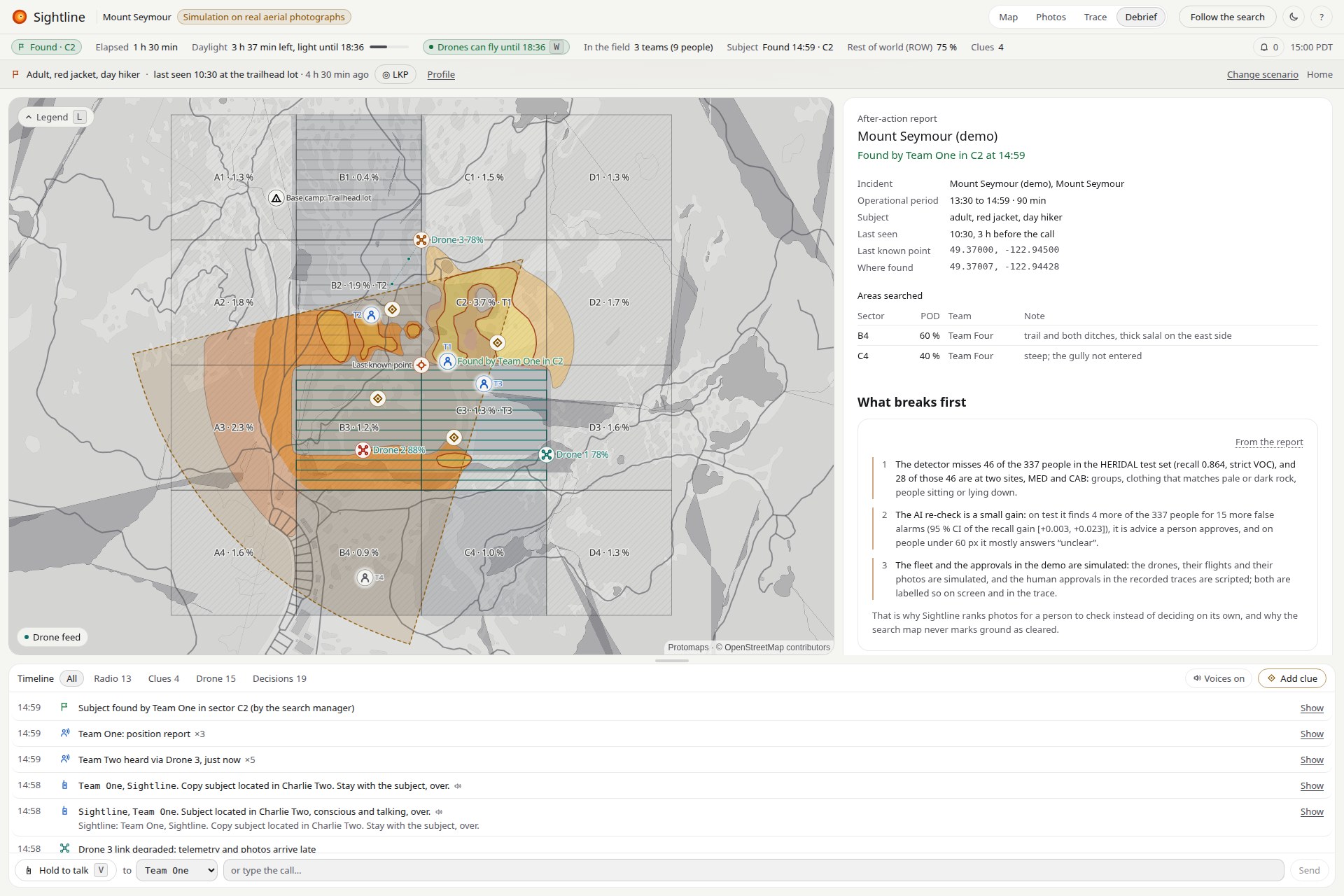
The Debrief after the find: the after-action report, the areas searched at their POD, and what breaks first, in the report's words.
-
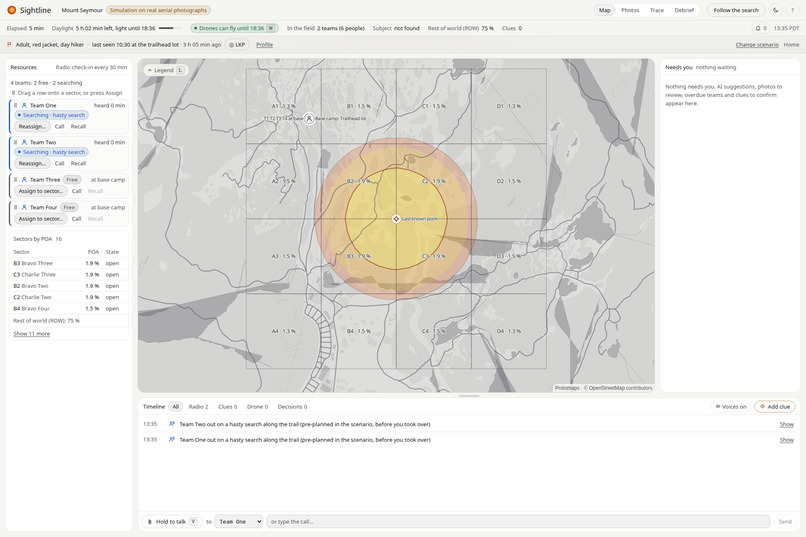
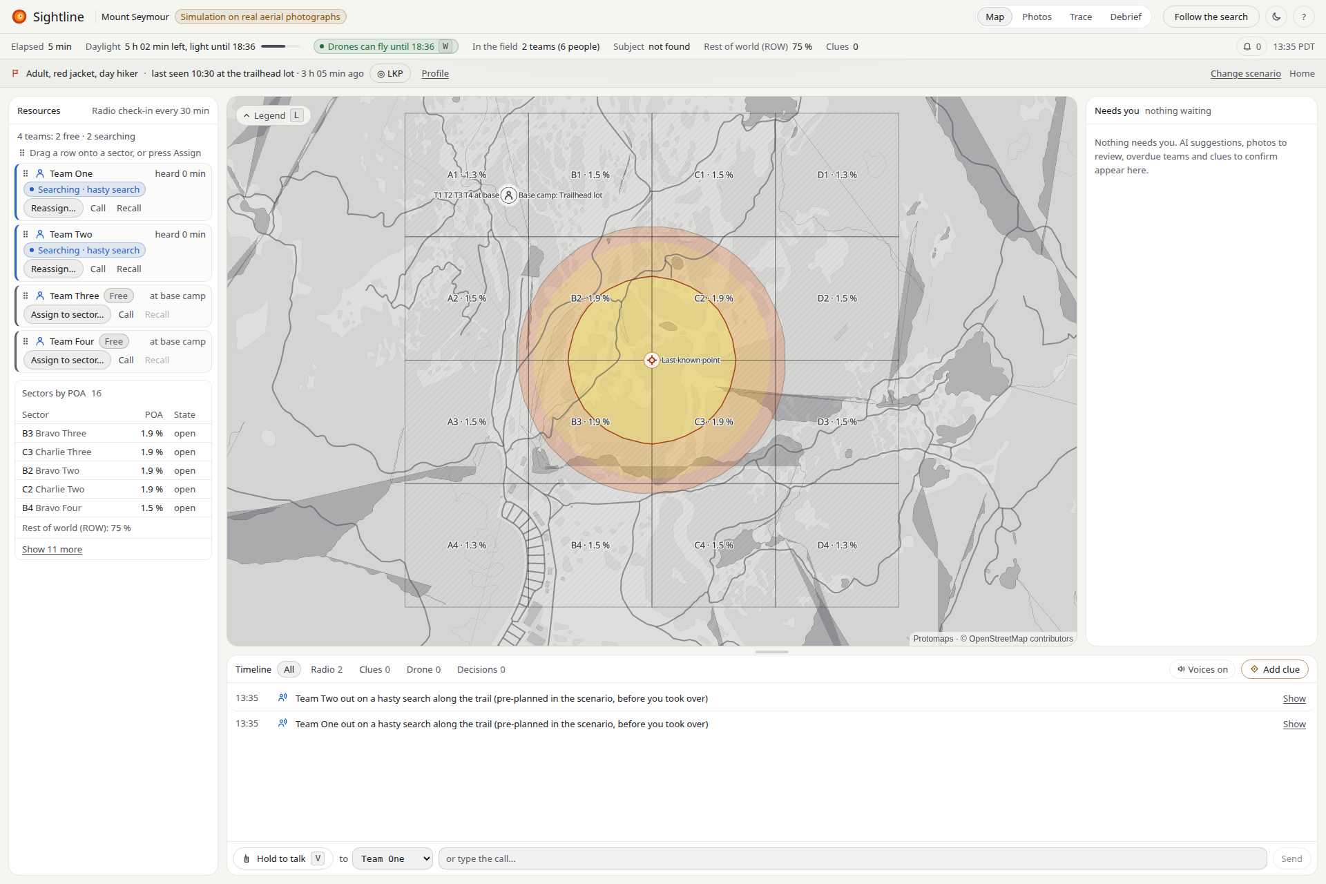
13:35, the call: the console on the overdue-hiker mission, lost-hiker rings around the last known point, two teams out on a hasty search.
Inspiration
A search-and-rescue drone brings back hundreds of photos per flight, and a missing person is about 70 px wide in a 4000×3000 photo. Volunteers reviewing by eye take about 33 s a photo and, in the published HERIDAL study, found 68 % of the people. Meanwhile the search manager decides where drones and ground teams go next, from radio reports and a paper map. This is not a remote-wilderness problem: North Shore Rescue, twenty minutes from downtown Vancouver, answers more than a hundred calls a year in the mountains above the city, and the difference between finding someone and not is often time. Plenty of tools flag pixels; none I found turns every photo, negative sweep and radio report into one updated probability map, with a logged approval gate between a suggestion and a drone or team.
What it does
- Detects each photo as it arrives with OpenCV 5
cv2.dnn, and places every detection on the map from the photo's GPS and camera pose. - Keeps a probability map of where the person could still be. Every photo, review, searched sector and clue updates it. Searched ground shows how well it was searched ("searched at POD 60 %"); the software never rules an area out.
- Takes a second look at uncertain detections: OpenCV 5 re-look tools (native-resolution zoom, CLAHE, re-detection) build better images, and NVIDIA Nemotron VL on Nebius Token Factory gives a verdict.
- Proposes the next move (promote a detection, fly or re-task a drone, assign a sector, alert the teams) with its reason. A person approves every one, logged with who and when.
- Talks to ground teams on a secondary radio channel and logs a clue only after a readback.
- Writes the files a command post files: ICS 204 per team, ICS 214 from the trace, CalTopo GeoJSON.
On the live site you are the search manager in a three-minute guided simulation: the AI proposes, you decide, and the end screen compares a manual search with yours (Without Sightline vs with Sightline, every assumption with its source). Open the console runs the same mission hands-on from the call.
Run a real search: #new starts a live mission on the AWS API: drop aerial photos and each is detected with OpenCV 5 cv2.dnn on the server and placed on the map.
How I built it
- OpenCV 5 sees. YOLO11s fine-tuned on 1024 px HERIDAL tiles, exported to ONNX and run on
cv2.dnnwith no PyTorch at run time: identical scores to PyTorch on the test set, 363 of 363 boxes matched one to one. Re-look tools, one per failure mode:zoom_nativefor small people, CLAHE for clothing that matches rock,redetect_regionfor groups and people lying down;cv2.fillPolyandcv2.blurfor coverage and canopy on the map. - NVIDIA models read, reason, listen and speak: Nemotron 3.5 Super VL (second look), Nemotron 3 Super (radio turns with tools), Nemotron 3 Nano (briefings, conditions), Parakeet and Magpie (speech).
- Nebius runs every model call (Token Factory) and the batch detection (a Serverless Job: 711 photos in 483 s, about $0.10). Tavily brings the forecast, warnings and park alerts that gate the drones.
- Every AI step in the demo is a real Nemotron answer from Nebius Token Factory: the demo mission and all four scenarios were re-recorded on Oct 26 with live calls (34 new calls, 50.1 s in all): three Nemotron 3.5 Super VL second looks per mission and one Nemotron 3 Nano briefing per assignment, replayed word for word, each labelled on screen with its model, "Nebius Token Factory" and its time; the Trace view counts them per mission.
- AWS: S3, an SQS FIFO queue with a dead-letter queue, an EC2 worker running
cv2.dnn, CloudWatch metrics and Secrets Manager; 7.1 s per photo from upload to processed. COOL on Graviton: the detector and API also run on Cloud Optimized OpenCV with bit-identical boxes (538 of 538). - The agent proposes and never acts: every tool call, model call, verdict, proposal and decision is one line of the mission's trace.
- The web console (React, TypeScript, MapLibre) is laid out like a command post: resources, the map, Needs you, and the timeline with the radio.
Challenges I ran into
- Small people in big photos. Shrinking a photo to the model's input drops test recall to 0.234; tiling at native resolution works. The second look mostly answers "unclear" on people under 60 px, and I kept that.
import ultralyticssetscv2.setNumThreads(0), which madecv2.dnn5× slower in any process that also loaded Torch.- Honest evaluation: every threshold chosen on validation, test scored once per decision; two early choices saw test, and the report says so.
Accomplishments that I'm proud of
- A real chain where OpenCV changes the decision: a person lying down, scored 0.18 (below the 0.29 threshold), zoomed from native pixels, called "yes, lying" by Nemotron VL, and proposed for review.
- The detector finds 86.4 % of people on the HERIDAL test set (strict VOC; 89.6 % on the study's looser scoring, against 68 % by eye).
- The whole loop live on AWS, and a technical report where every number links to its evidence.
- What breaks first, stated up front: the detector misses 46 of 337 test people (groups, rock-coloured clothing, people sitting or lying); the second look adds only 4 people for 15 false alarms; the fleet is simulated over real HERIDAL photos.
What I learned
The detector is no longer the hard part; what happens after a pixel is flagged is. Measuring that honestly gave small gains where I hoped for big ones (the second look; the planner, which beats a fixed order only when there is a clue), and I report them as measured. COOL taught me the same: image processing 1.14 to 1.35× faster, cv2.dnn not faster.
What's next for Sightline
Thermal imagery for night searches; photos arriving straight from the drone platform; a word error rate on real volunteers' voices over real handsets; and a field trial with a search-and-rescue team.
Built With
- amazon-cloudwatch
- amazon-ec2
- amazon-sqs
- amazon-web-services
- aws-graviton
- docker
- fastapi
- magpie
- maplibre
- nebius
- nebius-token-factory
- nemotron
- nvidia
- onnx
- opencv
- parakeet
- python
- pytorch
- react
- tavily
- typescript
- ultralytics
- vercel
- yolo

Log in or sign up for Devpost to join the conversation.