Project Description
Sidereal Helix is a high-performance, real-time 3D visualization tool designed to address the growing threat of Orbital Debris (space junk). As we launch mega-constellations like Starlink, Low Earth Orbit (LEO) is becoming dangerously overcrowded. Our project solves the problem of "invisibility" making the abstract math of orbital mechanics visually accessible and undeniable.
We built this application using a modern web stack optimized for physics performance:
- Frontend: React served as the UI framework, while React Three Fiber (R3F) and Three.js handled the WebGL rendering.
- Physics Engine: We utilized satellite.js to implement SGP4 (Simplified General Perturbations-4) propagation, calculating the real-time position and velocity of over 2,000 objects directly in the browser 60 times per second.
- Data & Hosting: The app ingests raw NORAD Two-Line Element (TLE) data from CelesTrak. It is deployed globally using Microsoft Azure Static Web Apps for low-latency delivery of our large datasets.
Purpose
We chose this problem because the Kessler Syndrome a theoretical scenario where a collision between two satellites generates a debris field that triggers a cascading chain reaction is becoming a reality. The collision between Iridium 33 and Cosmos 2251 in 2009 created thousands of pieces of shrapnel that still threaten the ISS today.
This project matters because space is critical infrastructure. We rely on it for GPS, climate monitoring, and global communication. If we pollute orbit, we trap ourselves on Earth.
- Motivation: We wanted to build a "Social Good" tool that raises awareness about orbital conservation.
- Impact: If developed further, Sidereal Helix could evolve from an educational visualization into a real-time situational awareness dashboard for satellite operators, allowing them to visualize conjunction assessments (collision risks) and plan delta-v maneuvers to avoid impact.
How it Works
Sidereal Helix turns your browser into a military-grade orbital command center.
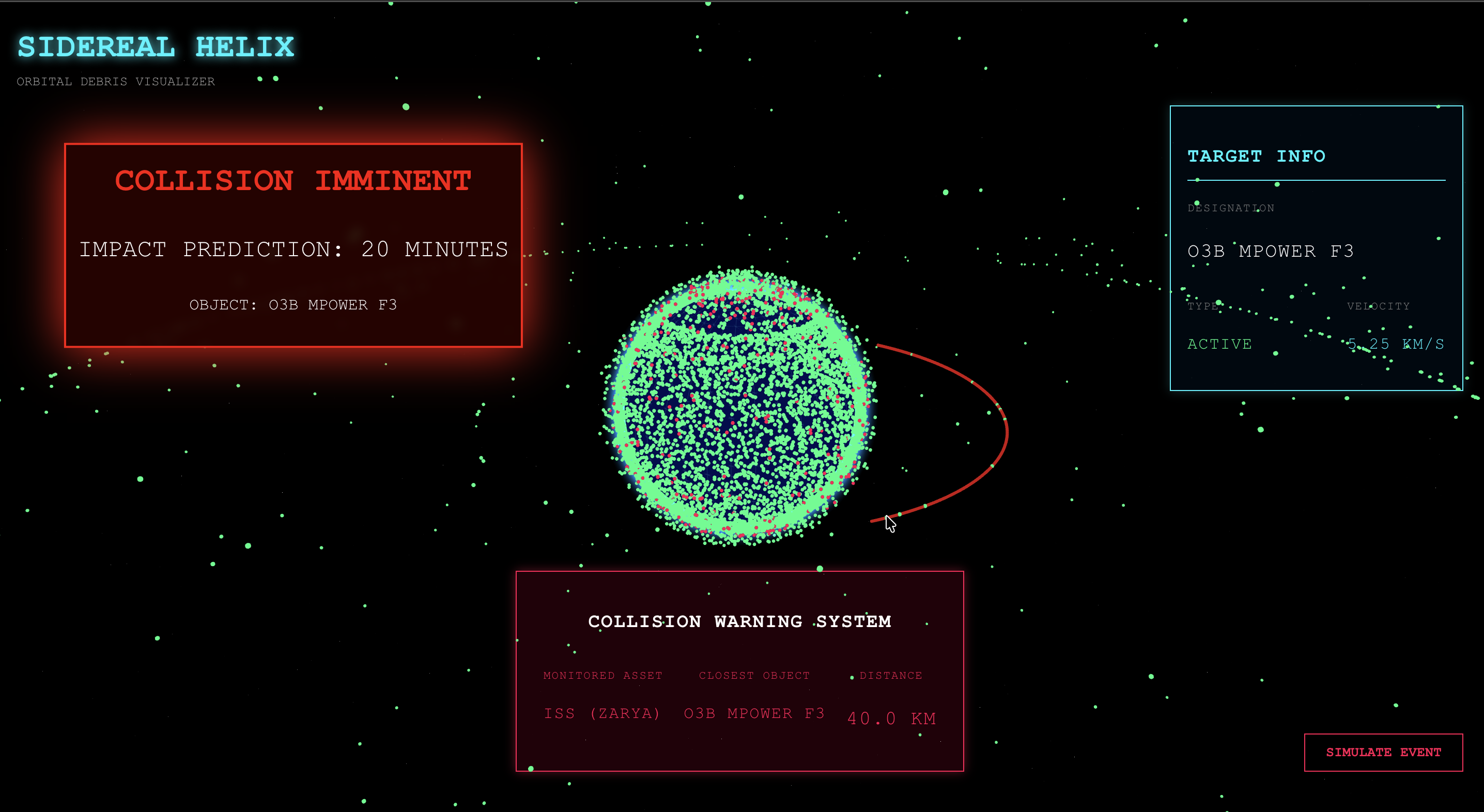
- Interactive 3D Tracking: Users enter a fully interactive 3D environment where they can rotate the Earth and zoom into specific orbital planes. Every green dot represents an active satellite, and every red dot represents tracked debris.
- Live Telemetry HUD: By hovering over any object, users get a Heads-Up Display (HUD) readout showing the satellite's name, type (PAYLOAD vs. DEBRIS), and real-time velocity in km/s.
- Collision Simulation: The core feature is the "Simulate Event" system. When users trigger this mode, the app:
- Identifies a real piece of debris (e.g., from the Cosmos 2251 cloud) currently in the dataset.
- Calculates a trajectory intercept path using orbital math.
- Visualizes a "Red Alert" scenario, drawing the collision course line and estimating "Time to Impact" to demonstrate how little time operators have to react.
- Resilient Architecture: We used a hybrid data approach. The app fetches live data from CelesTrak but includes a fail-safe local dataset of 25,000+ objects, ensuring the simulation works even in offline or low-bandwidth environments.

Log in or sign up for Devpost to join the conversation.