Inspiration
Disasters do not become catastrophic only because of their intensity. They become catastrophic when warnings arrive late, information is fragmented, reports remain unverified, and emergency resources fail to reach the people who need them.
We were inspired by the challenges faced by disaster-prone communities, particularly during urban flooding in India. Emergency departments often work with disconnected information systems, citizens struggle to report incidents, and responders lack a unified picture of rapidly changing ground conditions.
We asked ourselves: What if an intelligent system could identify risks before a disaster escalates, verify incidents as they happen, coordinate responders automatically, and help communities recover afterward?
That question led us to build Sentinel AI – Predictive Disaster Intelligence & Coordinated Response System.
What it does
Sentinel AI is an AI-powered disaster intelligence platform designed to manage the complete disaster lifecycle: BEFORE, DURING, and AFTER a hazard.
1. BEFORE – Predict and Prepare
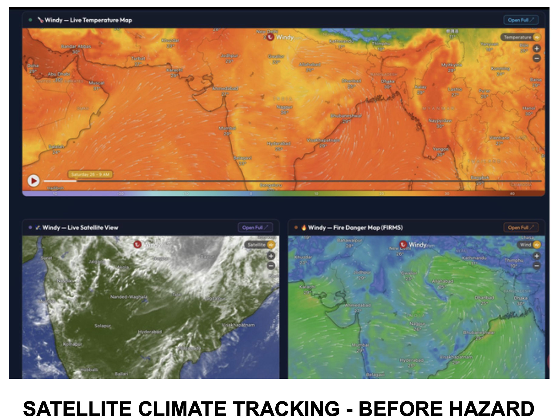
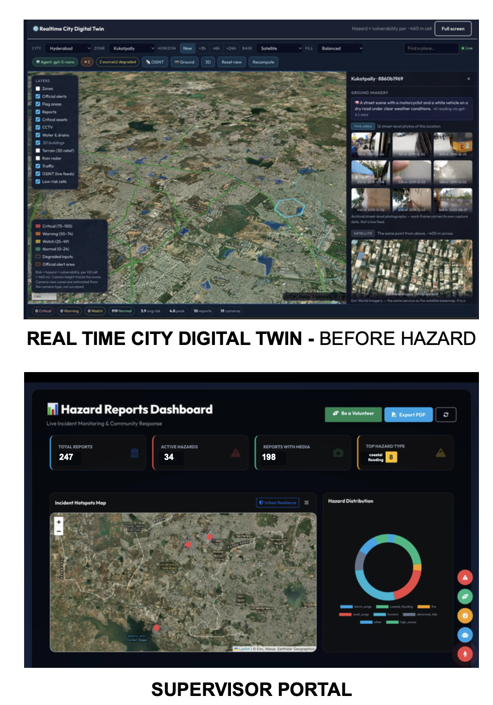
- Digital Twin combines weather, satellite, terrain, river, and infrastructure information into a geospatial risk model.
- An H3-based risk grid calculates localized hazard and vulnerability scores.
- The Prediction Agent identifies potential danger zones and generates hazard windows showing when a threat is expected to start, peak, and ease.
- Automated monitoring rescans risk conditions every five minutes.
2. DURING – Detect, Verify and Respond
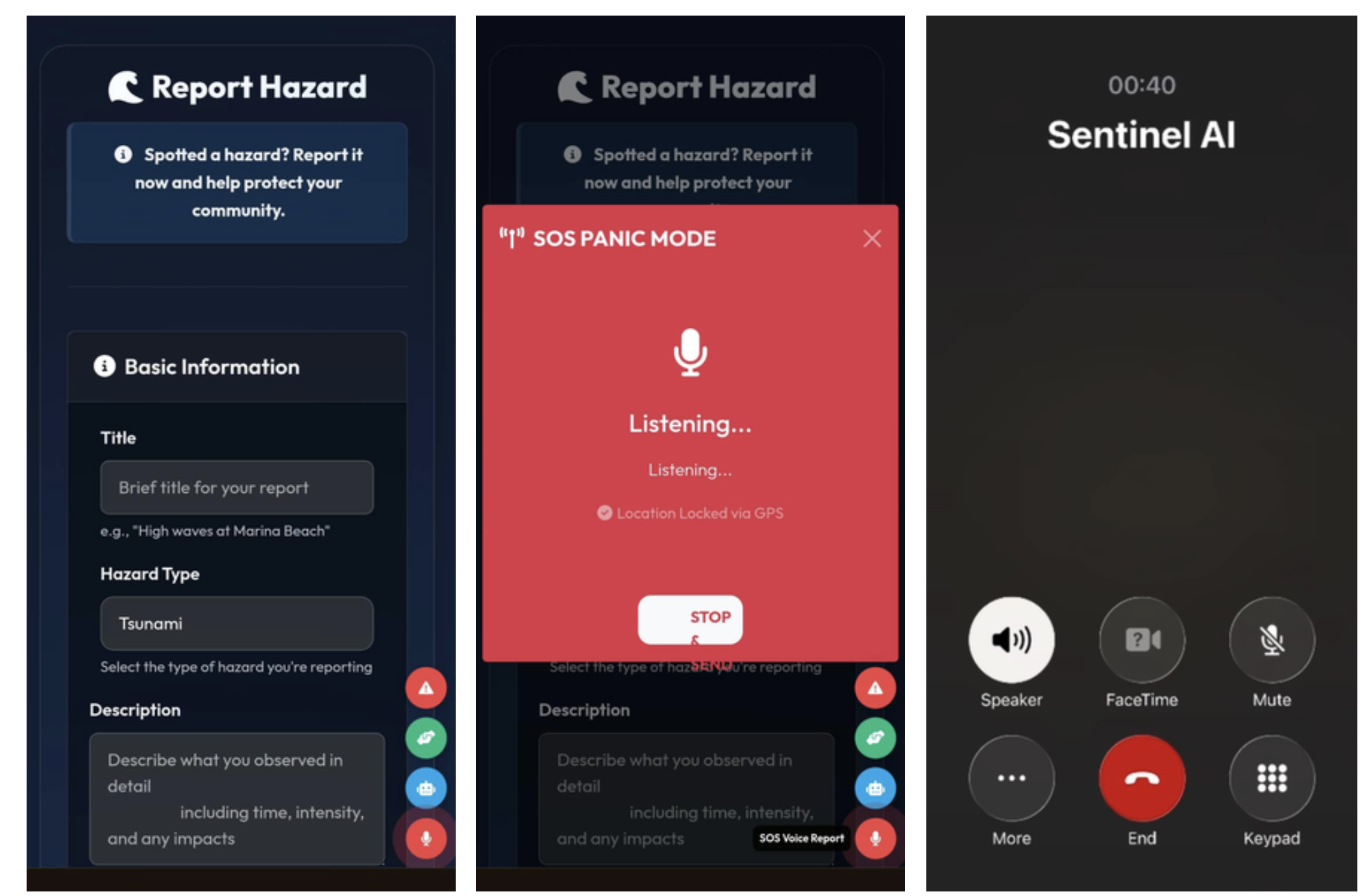
Citizens can report emergencies through three channels:
- Online reporting through the Progressive Web App.
- Voice-based reporting through an AI Calling Agent.
- One-tap SOS with geolocation.
The verification engine evaluates four signals: image authenticity, geographical risk, user quality, and climate alignment.
Reports receive a confidence score:
- 85% and above: Priority dispatch.
- 50–84%: Standard review.
- Below 50%: Held for further corroboration.
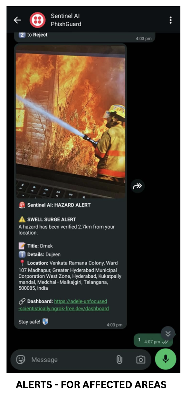
The system identifies duplicate incidents, prioritizes emergencies, and notifies nearby volunteers through WhatsApp and other communication channels.
It also supports six languages: English, Hindi, Telugu, Tamil, Malayalam, and Kannada.
3. AFTER – Recover and Reconnect
Sentinel AI extends beyond emergency response through LifeLine, a peer-to-peer resource-matching system.
Survivors can publish essential needs, while donors and volunteers can list available supplies. The platform matches needs with resources to support faster community recovery.
GPS and photographic evidence help establish accountability before an incident is marked as resolved.
How we built it
We developed Sentinel AI using a modular architecture combining geospatial intelligence, multi-agent AI, real-time data processing, and communication services.
AI and Multi-Agent Architecture
- OpenAI models for intelligent report verification and reasoning.
- NVIDIA Nemotron as a fallback for verification continuity.
- LangGraph for orchestrating prediction and agent workflows.
- Qwen3 for additional language and AI capabilities.
- NLP-based processing for multilingual incident information.
Backend and Infrastructure
- Python and Flask for backend services.
- PostgreSQL and PostGIS for geospatial data management.
- SQLite for lightweight storage.
- Docker for containerization.
- APScheduler for automated monitoring and background jobs.
- REST APIs for communication between modules.
Geospatial Intelligence and Data Sources
- Uber H3 for spatial indexing and localized risk scoring.
- Open-Meteo for weather information.
- RainViewer for precipitation radar.
- NASA GIBS for satellite imagery.
- OpenStreetMap and MapLibre for mapping.
- CWC, TGDPS, and other available weather and government data sources.
Frontend and Communication
- HTML, CSS, JavaScript, and Bootstrap 5.
- Leaflet.js and MapLibre GL for interactive maps.
- Progressive Web App with offline-first capabilities.
- Twilio for voice calls, messaging, and WhatsApp communication.
- Chart.js and Matplotlib for analytics and visualization.
The platform brings these components together through a unified operational pipeline, from risk prediction to incident verification, dispatch, and recovery.
Challenges we ran into
Building a disaster intelligence system introduced several engineering challenges.
1. Data fragmentation
Weather, satellite, river, and infrastructure information comes from different sources and formats. We had to normalize these inputs into a common geospatial representation.
2. False reports and duplicate incidents
Emergency systems cannot rely entirely on unverified citizen submissions. We implemented multi-signal confidence scoring, duplicate detection, image checks, and geographical corroboration.
3. Connectivity during disasters
Network failures can prevent citizens from accessing conventional applications. We introduced offline PWA reporting with synchronization when connectivity returns, alongside voice and SMS-based alternatives.
4. Multilingual accessibility
Communities communicate in different languages. Supporting six languages across reporting and communication workflows required additional processing and integration.
5. Reliable predictions
Missing or delayed external data can create misleading forecasts. We designed fallback handling so that elevated risk is not incorrectly interpreted as an all-clear when forecast data becomes unavailable.
6. Coordinating multiple agents and services
Integrating prediction, verification, prioritization, messaging, and volunteer dispatch into one workflow required careful orchestration and consistent data handling.
Accomplishments that we're proud of
We are proud to have transformed a disaster-management concept into a working prototype with interconnected intelligence and response workflows.
Some of our key accomplishments include:
- Built a geospatial Digital Twin with H3-based localized risk intelligence.
- Implemented multi-agent AI workflows for prediction and verification.
- Developed a four-signal report verification and prioritization engine.
- Integrated three citizen reporting channels: PWA, AI calling, and SOS.
- Enabled multilingual workflows across six languages.
- Implemented duplicate incident detection and corroboration.
- Developed automated volunteer notification and dispatch workflows.
- Built LifeLine for peer-to-peer disaster recovery.
- Created command dashboards for incident monitoring, resource coordination, and audit trails.
- Implemented offline-first reporting and synchronization.
Most importantly, Sentinel AI connects prediction, detection, response, and recovery instead of treating them as separate applications.
What we learned
Throughout development, we learned that building meaningful AI systems requires much more than integrating an LLM.
We gained practical experience in multi-agent orchestration, geospatial intelligence, risk modeling, API integration, asynchronous processing, image verification, multilingual workflows, and resilient system design.
We also learned the importance of human oversight in high-impact applications. AI should accelerate decisions and prioritize information, but critical emergency decisions must remain accountable and subject to appropriate human and official oversight.
Our biggest takeaway was that the real value of AI is not just predicting what might happen, but helping people take meaningful action at the right time.
What's next for Sentinel AI
We envision Sentinel AI evolving into a scalable disaster intelligence infrastructure.
Next development priorities:
- Advanced PostGIS spatial indexing for city-scale queries.
- WebSocket-based real-time notifications.
- Improved scheduling and background processing.
- More accurate and frequently recomputed hazard windows.
- Expanded Digital Twin coverage and prediction capabilities.
Long-term vision:
- Live IoT river-gauge and drainage-sensor integration.
- Satellite SAR-based flood mapping and post-disaster damage assessment.
- Native mobile applications with background geofencing.
- Self-hosted AI processing and India-region data residency.
- Integration pathways with NDMA, SDMA, emergency operation centres, and SACHET-compatible systems.
Our initial deployment roadmap focuses on Hyderabad urban flooding, followed by expansion to Bengaluru and coastal districts for cyclone and storm-surge preparedness.
Sentinel AI – Maximum Intelligence. Maximum Impact.
We believe disasters cannot always be prevented, but their impact can be reduced through timely intelligence, coordinated action, and empowered communities.
Predict before it happens. Verify before responding. Coordinate when every second matters. Recover together.
Built With
- ai
- artificial
- bootstrap
- css
- flask
- generative
- geospatial
- h3
- html
- intelligence
- javascript
- langgraph
- leaflet.js
- learning
- machine
- maplibre
- multi-agent
- nemotron
- nvidia
- openai
- postgis
- postgresql
- python
- twilio
- uber
