Inspiration
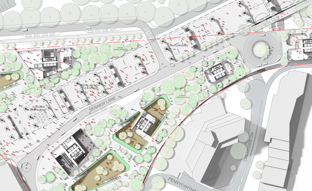
The Senakw Project is on a relatively small parcel of Squamish reserve land at the foot of the Burrard Bridge, across from downtown Vancouver. The Squamish Nation and Westbank are building 6000 rental apartments (80% market rentals cross-subsidizing 20% non-market rentals), in the form of high-rises up to 60 storeys. The height and density of the project reflects the extreme shortage of housing in Vancouver, and thus sky-high market rents. Because it's Squamish reserve land, the city of Vancouver's extremely restrictive zoning laws don't apply.
Many Vancouver residents are unhappy with the Senakw development due to its unprecedented density and scale. The project plans to build 11 high-rise towers - some reaching up to 59 storeys - on just over 10 acres of reserve land near Kitsilano, resulting in a population density that would exceed 235,000 people per square kilometre, far surpassing even Manhattan. The sheer height and volume of the towers have sparked concerns about shadowing, traffic congestion, and a dramatic loss of mountain and water views for nearby residents.
I live near the new Senakw project in Kitsilano and I was curious to see if my views of the city and North Shore mountains would change, so I built a visualization tool https://senakw.afi.dev/ that overlays the development's building envelope on a 3D Google Map.
What it does
Senakw Vancouver lets you enter any Vancouver address to visualize how the Senakw development will appear from that location, allowing you to see firsthand if it will impact your view of the city skyline.
How we built it
We used Google Photorealistic 3D Tiles for the three dimensional base map and added the building envelopes manually, using publicly available data from the City of Vancouver Senakw Development website and various online publications.
Challenges we ran into
The Photorealistic 3D Tiles API doesn’t include a built-in method to view one location from the perspective of another, so we used basic trigonometry to calculate the correct viewing angle manually.
Calculate the haversine distance from the address to the Senakw Development (49.273605, -123.142647). This is how far away your are, also known as range.
Compute the heading (measured in degrees clockwise, from North) between the selected address and Senakw. This is your viewing angle.
Once we get the heading and range, we use the
flyCameraTo()function to plant our camera at the correct spot range meters away from Senakw, facing heading degrees due North.
My blog post Senakw Vancouver will it block your view? explains these steps in greater detail.
Accomplishments that we're proud of
A big reason why local residents are unhappy with the Senakw Project was the lack of transparency around what is being planned for the area. Web-based 3D building models are a powerful tool for sharing project details and gathering community feedback before approval. In the future, I believe major real estate developments will be required to publish interactive 3D models online as part of the planning and rezoning process.
What we learned
3D mapping was once limited to expensive enterprise software, accessible only to universities, large corporations, and government agencies. But APIs like Google’s Photorealistic 3D Tiles have made 3D mapping far more accessible. As a result, I expect personal and community-led 3D mapping projects to become increasingly common in the future.
What's next for Senakw Vancouver - Will it Block your View?
Afi Labs recently signed a contract with a major real estate developer in Vancouver to create 3D visualizations for a new project on the city’s west side. As web-based 3D mapping becomes a widely accepted alternative to physical scale models, I anticipate growing commercial interest in this technology.
Built With
- photorealistic-3d-tiles
- places-api
- react

Log in or sign up for Devpost to join the conversation.