Inspiration
Satellite imagery plays a critical role in modern decision-making, but the tools required to analyze it often remain specialized and difficult to access. SATERYS was designed to make Earth-observation analysis more accessible by allowing users to build visual workflows that transform raw imagery into actionable information for faster, more informed decisions.
SATERYS began as an open-source geospatial toolkit—a community project for building Earth observation pipelines—but has since evolved into a far more ambitious system. This version represents the evolution of that original vision: a reimagined AI-native remote sensing platform where Amazon Nova’s reasoning capabilities and specialized AI agents sit at the center of workflow creation and analysis.
With more than six years of professional and academic experience in geospatial science, I built SATERYS to embed domain knowledge directly into the platform so results remain reliable, explainable, and usable in operational contexts. At the same time, the platform aims to democratize access to geospatial analysis by enabling professionals who do not have access to GIS or remote sensing experts to generate meaningful insights from satellite imagery.
What it does
SATERYS enables users to build and run Earth-observation workflows through a visual interface that converts satellite imagery into operational insights. By enabling repeatable analysis pipelines, the platform allows teams to move from imagery to decisions without requiring extensive GIS engineering expertise.
The platform targets operational needs across sectors such as energy, agriculture, government, disaster response, finance, insurance, mining, and logistics. Users can generate, run, and refine workflows that produce consistent results across datasets and geographic regions.
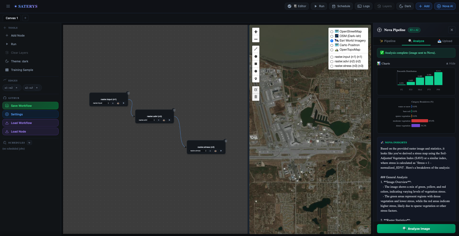
Through Amazon Nova integration, users can describe an analysis objective in plain language and have the system—through AI agents—generate a runnable geospatial pipeline that appears directly on the visual canvas.
How we built it
SATERYS combines a Python-based geospatial processing engine with a modern web interface designed for visual workflow creation. The backend executes modular analysis nodes and plugins, enabling workflows to remain extensible and reusable, while the frontend provides a node-based canvas with integrated map previews so users can iteratively build and validate analyses.
Each node defines standardized inputs, parameters, and outputs, ensuring workflows can be reused across datasets and geographic regions. Notebook-style exploration is also supported so experimental analysis can evolve into reusable workflow components.
Amazon Nova is integrated directly into the system to accelerate workflow creation. Users can describe an analysis objective in natural language and have Nova, together with AI agents responsible for pipeline generation and interpretation, generate a runnable pipeline compatible with the platform’s node architecture. The generated workflow can immediately be executed, previewed, and refined within the visual canvas.
Challenges we ran into
One of the main challenges was designing a node system that remains consistent and reusable across datasets and scenarios. This required defining standardized node interfaces and ensuring those definitions could be translated into clear, validated UI controls while preserving advanced geospatial functionality.
Another challenge involved ensuring that AI-generated pipelines could be reliably executed within the platform. Considerable work went into structuring prompts and responses for Amazon Nova so that generated code and workflow definitions match SATERYS’ internal pipeline format, making outputs directly executable and reproducible.
Accomplishments that we're proud of
A key accomplishment in SATERYS is the ability to generate complete, runnable geospatial workflows using AI and AI agents rather than simply providing suggestions. Through Amazon Nova integration, users can provide a plain-language objective and an imagery source—such as satellite data stored in S3—and the system generates a structured pipeline that appears directly on the visual canvas.
Users can immediately run the pipeline, preview results, and refine the workflow while maintaining reproducibility and transparency. This significantly reduces the effort required to build repeatable geospatial analyses.
What we learned
Building SATERYS demonstrated that speed and automation only matter if results remain explainable and reproducible. Standardizing node interfaces and workflow structures proved essential for ensuring analyses remain stable across different datasets and regions.
We also learned that AI is most effective when it produces structured artifacts—such as executable pipelines—rather than general suggestions. Constraining Amazon Nova’s outputs to match the platform’s architecture allows AI responses to become immediately operational components of the system.
What's next for SATERYS
Future development will expand SATERYS toward more advanced Earth-observation capabilities. Planned features include land-cover and change-detection workflows using time-series algorithms such as CCDC and LandTrendr.
The platform will also introduce geofencing-based reporting to generate automated summaries and alerts for defined areas of interest, supporting faster situational awareness in disaster response and field operations.
SATERYS will further extend its pipeline system to drone imagery, enabling near real-time analysis using AWS Rekognition and integrating satellite, aerial, and drone data within the same reproducible workflow environment.
Built With
- amazon-web-services
- apprunner
- bedrock
- docker
- javascript
- jupyter
- nova
- python
- s3
- svelte
- typescript

Log in or sign up for Devpost to join the conversation.