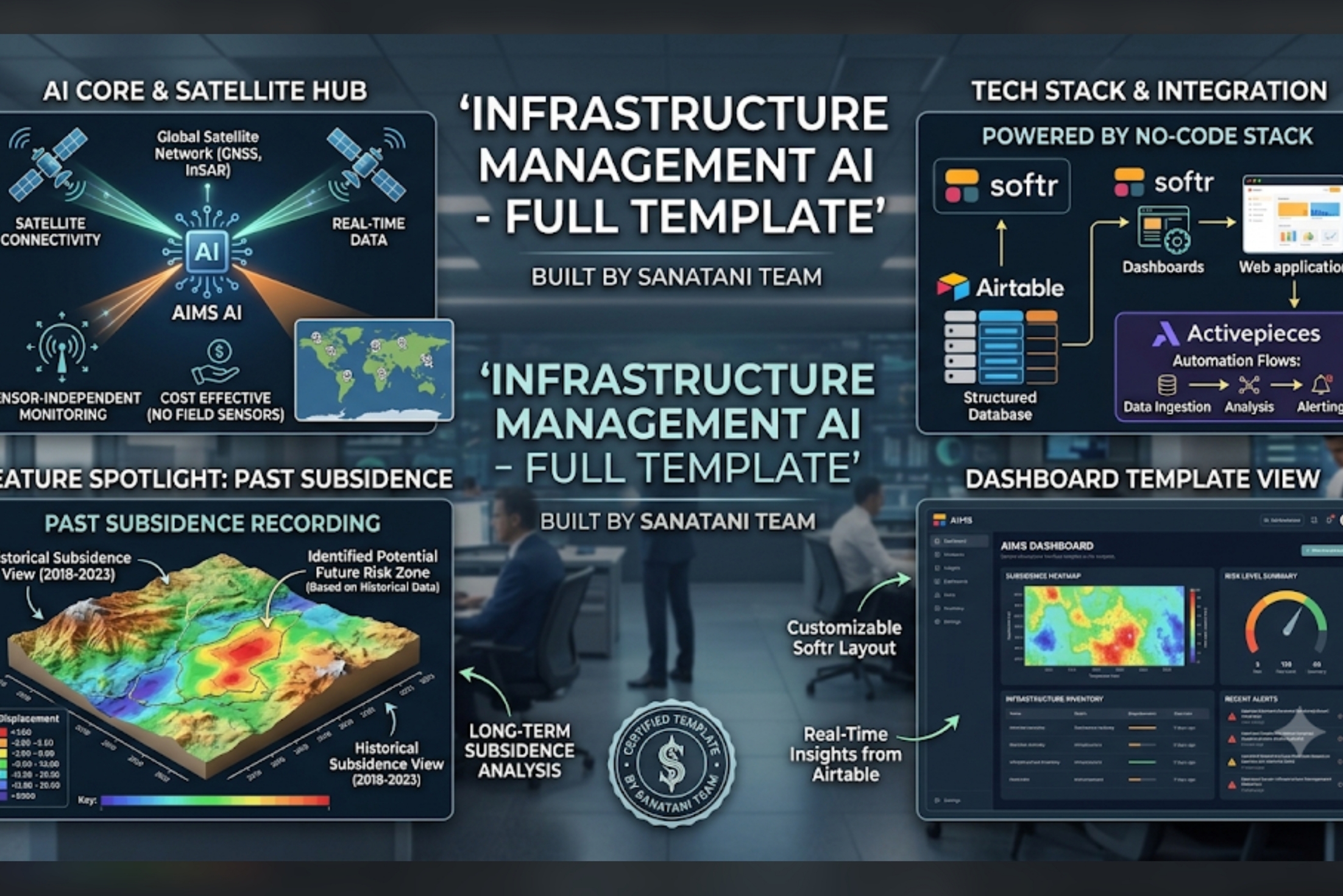
Our Journey: Infrastructure Management AI What Inspired Us The inspiration behind our project, Infrastructure Management AI, dates back to a major incident involving a busy overpass near our hometown. From the outside, everything looked perfectly normal. However, underlying ground movement (Past Subsidence) was silently compromising the bridge's foundation. One day, a massive crack appeared, forcing an immediate, months-long shutdown. It disrupted thousands of daily commuters and cost the local economy millions. The core issue? Traditional structural monitoring relies on incredibly expensive, high-maintenance on-field sensors, which most municipalities cannot afford. This realization deeply moved our group, Team Sanatani. We asked ourselves: What if we could protect public infrastructure without needing a single physical sensor on the ground? What if we could use space-public eyes to watch over our cities? That question inspired us to build a cost-effective, satellite-driven solution. How We Built It Driven by our vision, we built a Sensor-Independent and Cost-Effective infrastructure tracking template. Since we wanted to deploy a functional, agile prototype rapidly, we chose a powerful No-Code/Low-Code tech stack: Softr: To design a clean, highly accessible, and customizable front-end dashboard for city administrators. Airtable: Serving as our structured, real-time database to house historical subsidence metrics and risk levels. Activepieces: Managing our backend automation flows—handling data ingestion, identifying risk markers, and instantly routing emergency alerts. The system analyzes long-term satellite connectivity and historical data to flag potential future risk zones well before visible damage occurs. Challenges We Faced Building a sophisticated AI monitoring hub without traditional coding presented unique hurdles: Data Simplification: Translating complex global satellite network metrics (like InSAR and GNSS data) into a simplified, readable heatmap on a no-code dashboard was a massive puzzle. We had to rethink how data was structured inside Airtable. Logic Constraints: Creating multi-layered alerting automation flows within Activepieces required a lot of trial and error to ensure that critical risk reports triggered instantly without lagging. Visualizing the Past: Building a "Past Subsidence Recording" feature that dynamically reflects shifting terrain from 2018–2023 pushed the layout boundaries of Softr, forcing us to get creative with embedded visual modules. What We Learned This hackathon has been an invaluable learning experience for Team Sanatani. We learned that No-Code does not mean Low-Power. Tools like Softr, Airtable, and Activepieces allowed us to engineer a complex, data-driven prototype in days—a task that traditionally takes months of hard coding. More importantly, we learned how to approach civic problems with empathy, discovering that satellite technology combined with modern automation can make infrastructure safety accessible to every town, regardless of their budget.
Built With
- activepeices
- airtable
- softr

Log in or sign up for Devpost to join the conversation.