Inspiration
SAMUDRANETRA AI was inspired by a simple problem in maritime monitoring: AIS can tell us where cooperating vessels are, but AIS signals can also be missing, incorrect, interrupted, or deliberately switched off. A vessel may disappear digitally, but it cannot disappear physically. That led us to explore whether satellite imagery, AIS data, and geospatial intelligence could be combined to identify vessels that ordinary tracking systems may miss.
What it does
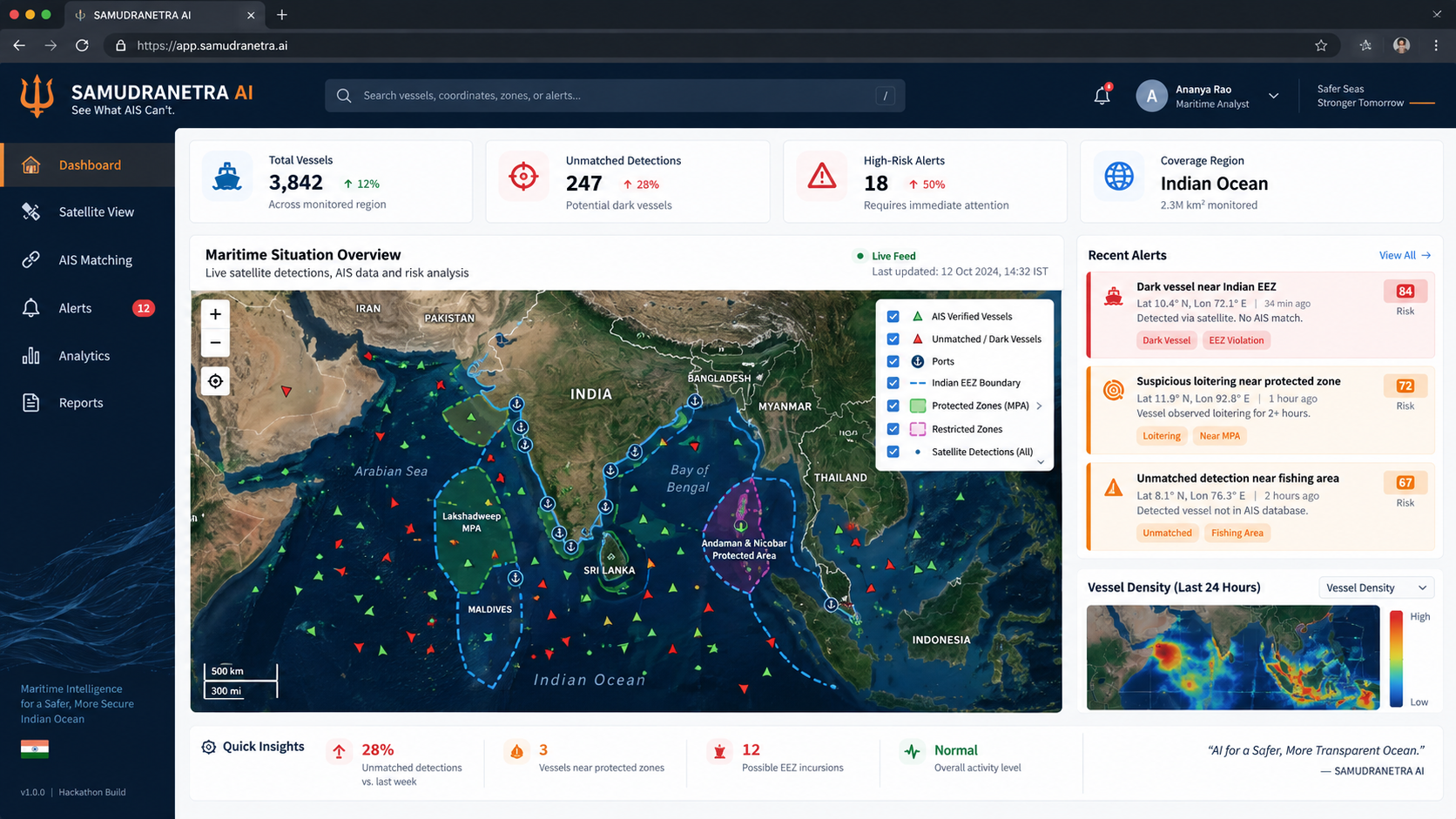
SAMUDRANETRA AI is an AI-powered maritime intelligence platform designed to detect and prioritize potentially suspicious vessels.
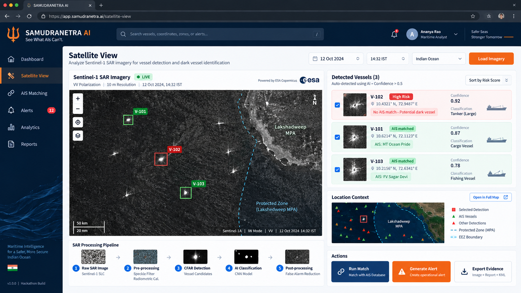
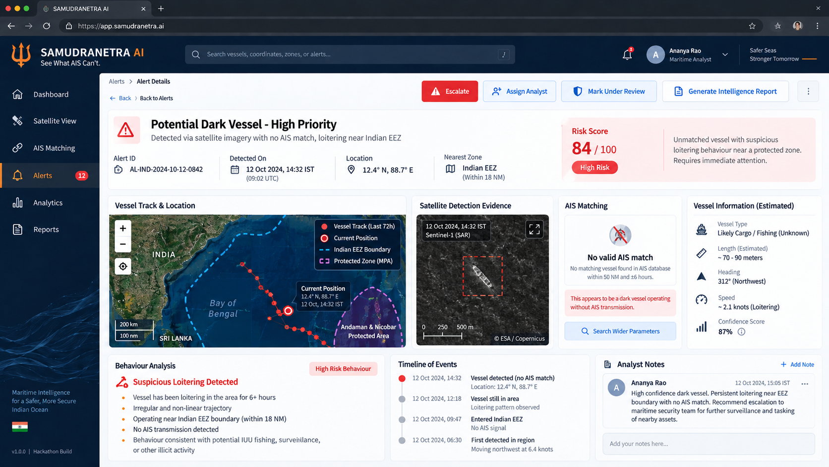
The system uses Sentinel-1 SAR satellite imagery to detect vessels, then compares those detections with AIS vessel data. If a detected vessel has a valid AIS match, it can be treated as a verified vessel. If no match is found, the system flags it as a potential dark vessel and analyzes additional factors such as trajectory, behaviour, nearby fishing areas, ports, protected zones, restricted areas, and the Indian EEZ. The result is a contextual risk score and alert priority for analyst review.
The goal is not to automatically accuse a vessel of illegal activity, but to help maritime authorities focus their attention on the detections that deserve investigation first.
How we built it
We designed SAMUDRANETRA AI as a three-layer system.
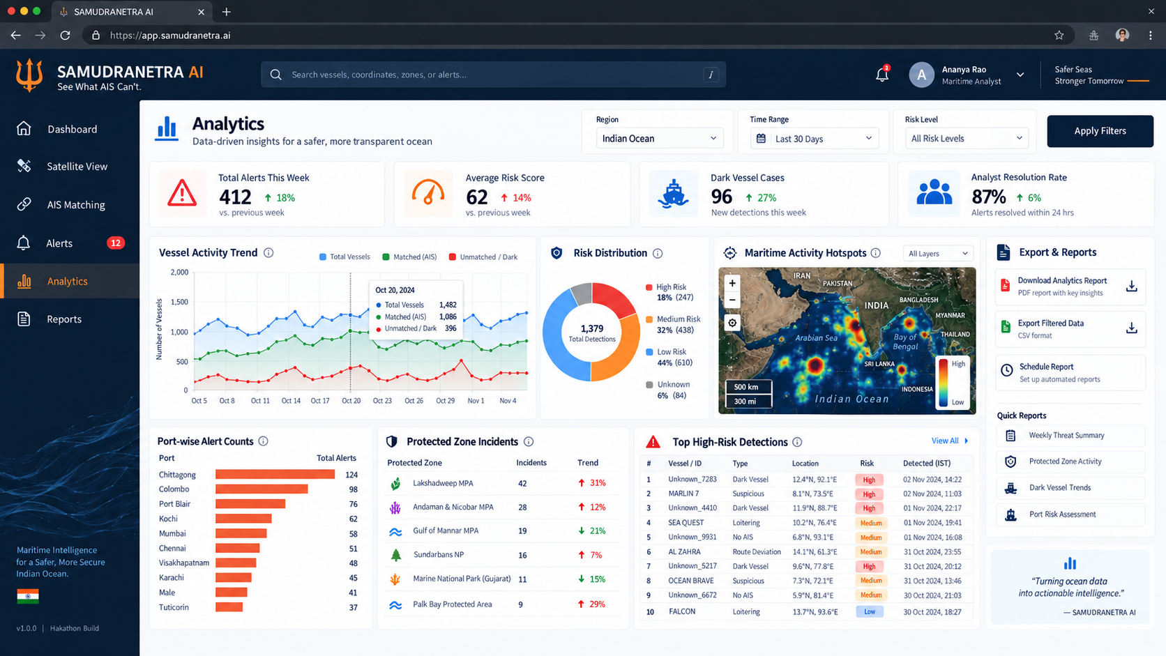
The data layer combines Sentinel-1 SAR imagery, AIS feeds, EEZ and coastal boundaries, ports, protected areas, historical vessel tracks, and a geospatial detection store. The intelligence layer performs SAR preprocessing, AI-based vessel detection, AIS matching, trajectory anomaly analysis, geospatial rule evaluation, risk scoring, and alert generation. The presentation layer provides a maritime GIS dashboard, satellite viewer, vessel-risk map, incident cards, analyst console, and intelligence reports.
Our proposed technology stack includes Python, PyTorch, YOLO, OpenCV, NumPy and Pandas for AI and computer vision; Sentinel-1, Copernicus Data Space, Rasterio, GDAL, GeoPandas and QGIS for Earth observation and geospatial processing; and FastAPI, PostgreSQL, PostGIS, React, TypeScript and Leaflet/MapLibre for the application and visualization layers.
Challenges we ran into
One of the biggest challenges was designing a system around imperfect maritime data. A missing AIS signal does not automatically mean a vessel is suspicious, so simply detecting an unmatched ship is not enough. SAMUDRANETRA therefore has to combine satellite evidence with behaviour, trajectory, geographic context, and human review before assigning priority.
Another challenge was keeping the solution practical and affordable. Continuous wide-area maritime monitoring can be expensive, so we focused on an open-data-first and software-first approach, using Sentinel-1 and open geospatial technologies instead of requiring custom hardware for the initial pilot.
We also had to think carefully about scalability, data availability, latency, and validation because real-world satellite and AIS coverage is not always perfect.
Accomplishments that we're proud of
We are proud that SAMUDRANETRA AI evolved beyond a simple vessel-tracking concept into a complete maritime intelligence architecture.
The project combines Earth observation, computer vision, AIS intelligence, geospatial analysis, anomaly detection, risk scoring, and human-in-the-loop decision support in one system.
We also designed a clear path from detection to action:
Satellite Detection → AIS Matching → Anomaly Detection → Contextual Risk → Analyst Review → Alert / Investigation Priority.
Another accomplishment is keeping the platform highly scalable. The same detection pipeline can grow from a pilot coastal region to state-level monitoring, east/west coast coverage, the Indian EEZ, and eventually broader regional maritime intelligence.
What we learned
Building SAMUDRANETRA AI taught us that powerful AI systems are not only about creating predictions. In safety-critical applications, context, explainability, evidence, and human review are just as important as the model itself.
We also learned how different technologies can complement each other. SAR imagery shows the physical presence of vessels, AIS describes cooperating vessel movement, geospatial information gives the detection context, and AI helps prioritize which cases deserve attention.
Most importantly, the project reinforced the idea that the best AI systems should assist human decision-makers rather than blindly replace them.
What's next for SAMUDRANETRA AI
The next step is to move SAMUDRANETRA AI from system design toward a working end-to-end prototype.
We plan to strengthen the SAR vessel-detection pipeline, implement real AIS spatio-temporal matching, improve trajectory and loitering anomaly detection, and build the interactive maritime GIS dashboard.
We also want to test the system on realistic coastal scenarios, validate risk scoring using historical vessel activity, and measure detection accuracy, false-positive rates, and operational usefulness.
After validation, SAMUDRANETRA AI could expand from a coastal pilot toward Indian EEZ monitoring, fisheries protection, port intelligence, protected-zone surveillance, and institutional maritime decision support.
SAMUDRANETRA AI: See What AIS Can't.
Built With
- copernicus-data-space
- fastapi
- gdal
- geopandas
- leaflet/maplibre
- numpy
- opencv
- pandas
- postgis
- postgresql
- python
- pytorch
- qgis
- rasterio
- react
- sentinel-1
- typescript
- yolo


Log in or sign up for Devpost to join the conversation.