SafeSteps: Smarter Walking, Safer Journeys 🚶♂️📍 Inspiration
Walking is one of the most accessible and sustainable ways to get around, yet pedestrians often face hazards that traditional navigation tools overlook—icy sidewalks, construction zones, blocked pathways, and unsafe crossings. While most mapping platforms prioritize drivers, pedestrian-specific safety information is rarely surfaced in real time.
SafeSteps was created to address this gap by providing pedestrians with hazard-aware navigation and a way to contribute to community safety through shared, real-world reporting.
What It Does
- SafeSteps is a pedestrian-first navigation system that helps users make safer walking decisions by surfacing hazards along their route and dynamically suggesting alternative paths.
Key Features
Real-Time Hazard Awareness: Displays reported hazards along a user’s walking route.
Intelligent Rerouting: Suggests safer alternative paths when hazards are detected.
Community Hazard Reporting: Allows users to quickly report hazards such as icy sidewalks, debris, or blocked paths.
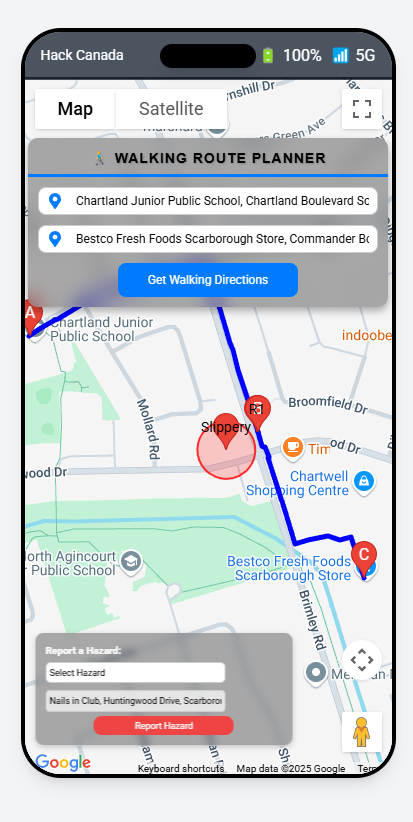
Map-Based Navigation: Integrates with Google Maps to provide a familiar and seamless walking experience.
Whether commuting to class, heading to work, or walking at night, SafeSteps helps users stay informed and avoid unexpected dangers.
How We Built It
SafeSteps was designed with a modular, scalable architecture:
Frontend: Built with React and Tailwind CSS for a clean, responsive user interface.
Navigation & Routing: Integrated the Google Maps API for pedestrian routing and dynamic rerouting.
Backend & Data Storage: Used MongoDB to store and retrieve user-reported hazard data.
Workflow Orchestration: Leveraged Orkes Conductor to manage hazard detection, validation, and rerouting logic in real time.
How It Works
Route Selection: Users enter a starting point and destination for walking navigation.
Hazard Matching: The system checks reported hazards along the route.
Rerouting Decision: If a hazard is detected, users can reroute or proceed with awareness.
Hazard Reporting: Users submit new hazards via a simple form, updating the system for others.
This community-driven feedback loop continuously improves route safety for all users.
Challenges We Faced
Hazard Reliability: Ensuring reported hazards are relevant, accurate, and useful.
API Integration: Coordinating real-time Google Maps routing with hazard-aware workflows.
Dynamic Rerouting: Handling route updates smoothly as new hazard data is introduced.
Overcoming these challenges required careful system design and iterative testing.
Accomplishments
Built a working pedestrian navigation system with real-time hazard awareness.
Successfully implemented hazard-based rerouting logic.
Delivered a clean, intuitive user experience suitable for everyday use.
What’s Next
SafeSteps has strong potential for expansion:
AI-Powered Hazard Prediction: Use historical data to predict high-risk areas.
Advanced Hazard Classification: Incorporate weather data and severity scoring.
City Integration: Connect with municipal infrastructure and open data sources for automated updates.
Why SafeSteps?
- SafeSteps empowers pedestrians with information that traditional navigation tools ignore. By combining real-time data, community reporting, and intelligent routing, it makes walking safer, smarter, and more reliable.
“Step confidently. Walk smarter. Stay safe.”

Log in or sign up for Devpost to join the conversation.