-
-
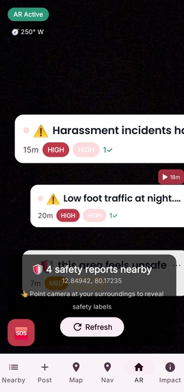
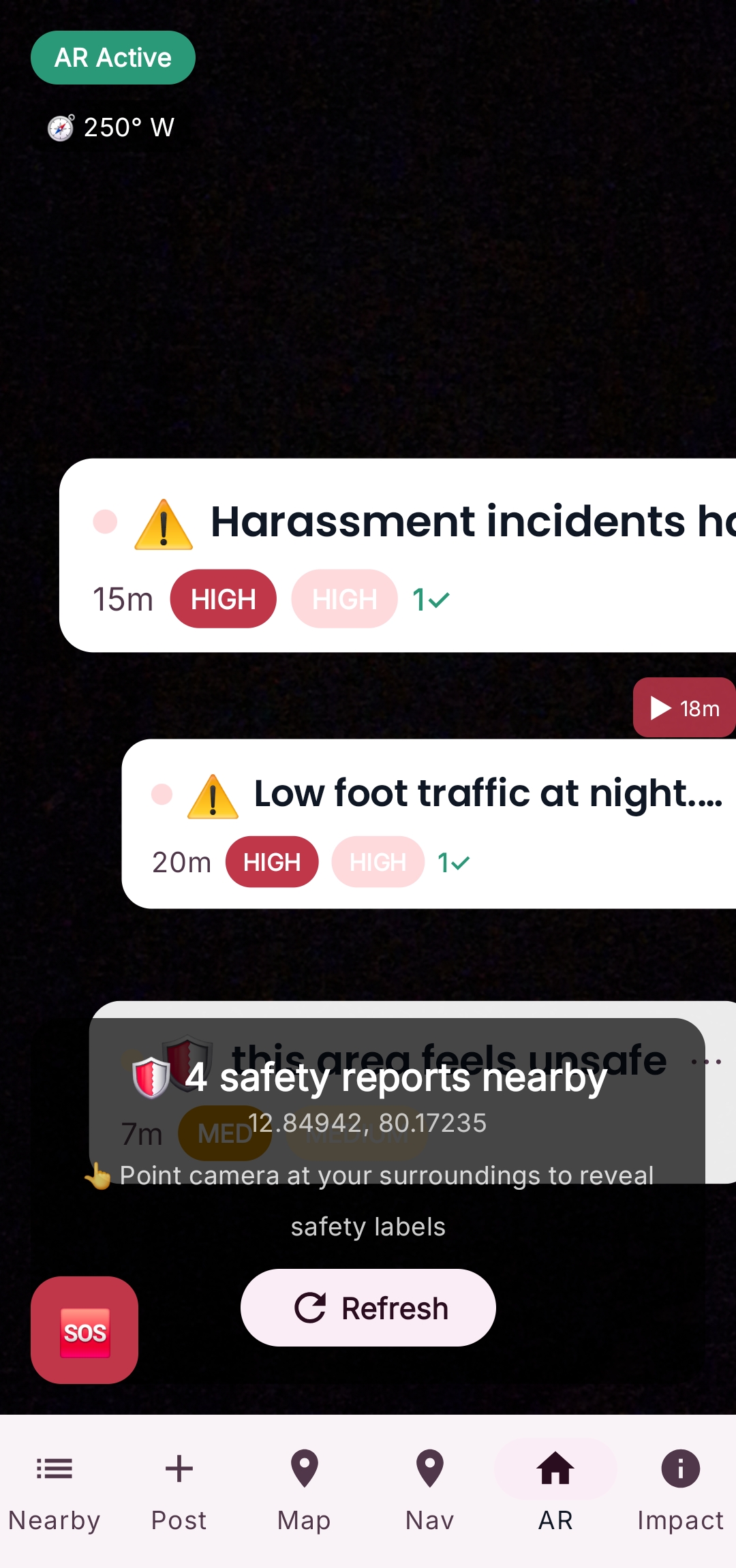
ARCore overlays nearby safety reports directly onto the real world, helping users instantly see potential risks around them.
-
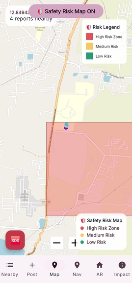
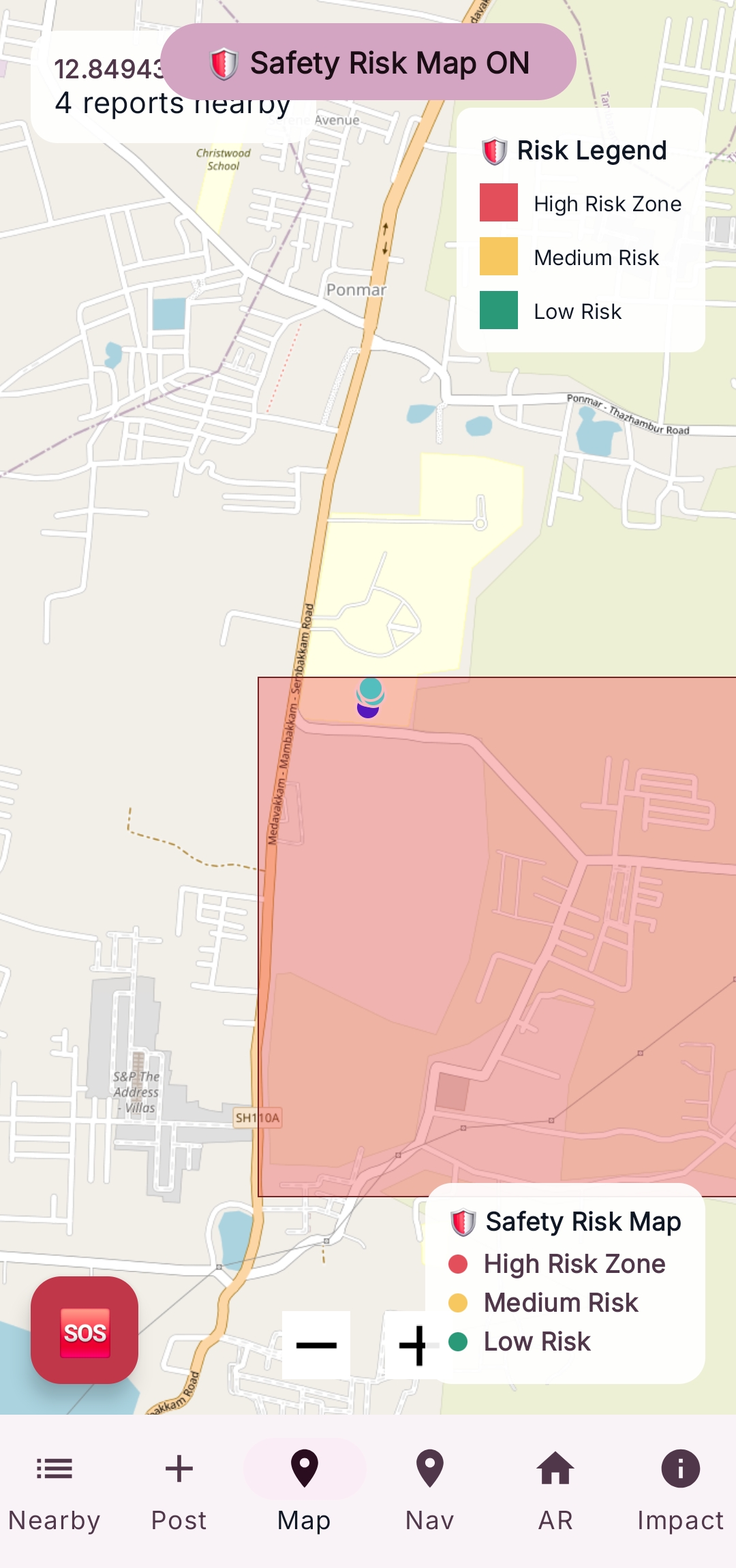
Map heat zones visualizing community-reported safety risks.
-
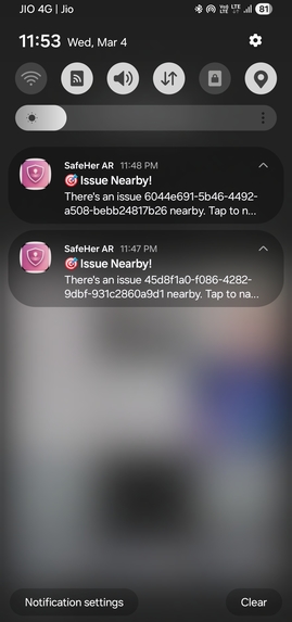
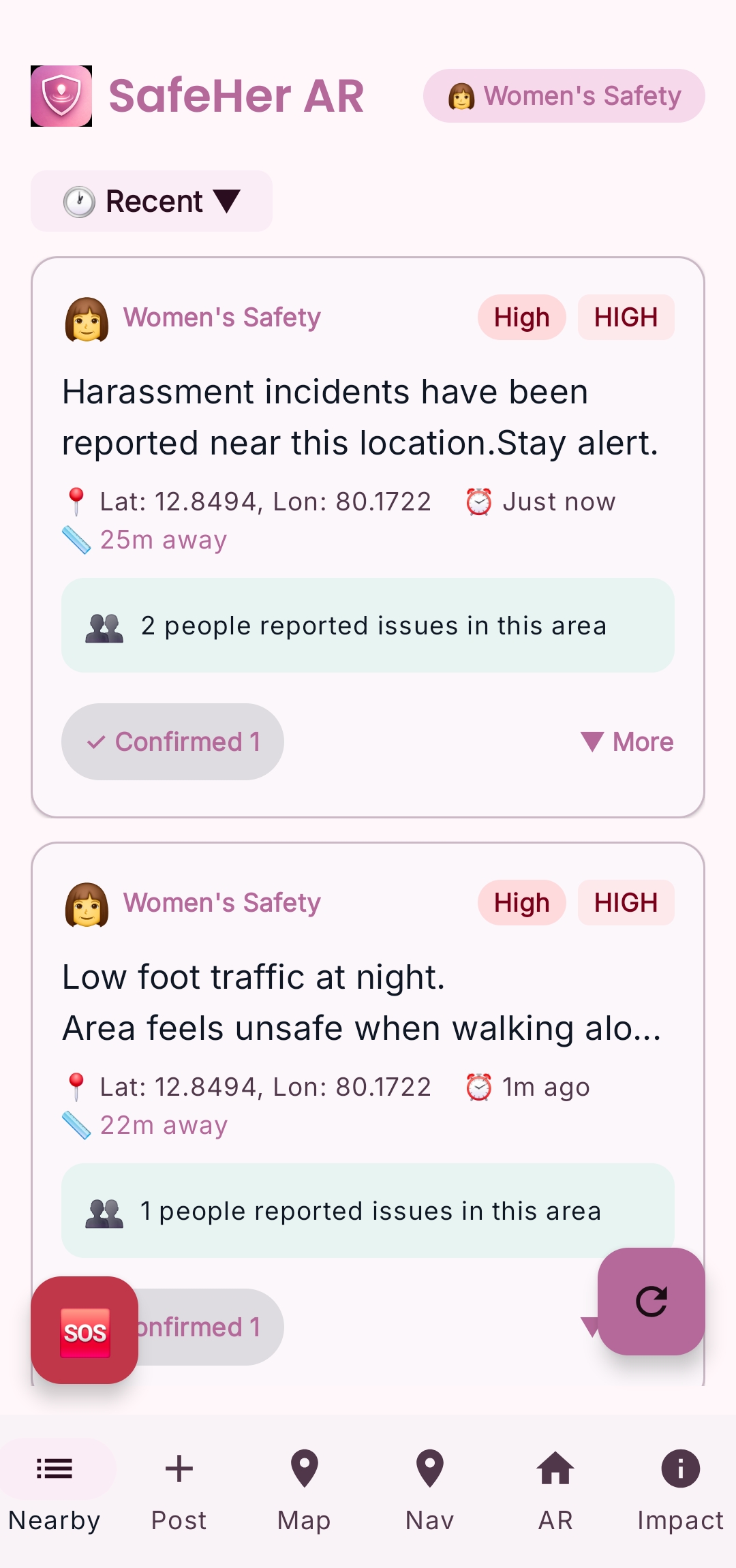
Real-time alerts notify users when they approach a reported safety risk.
-
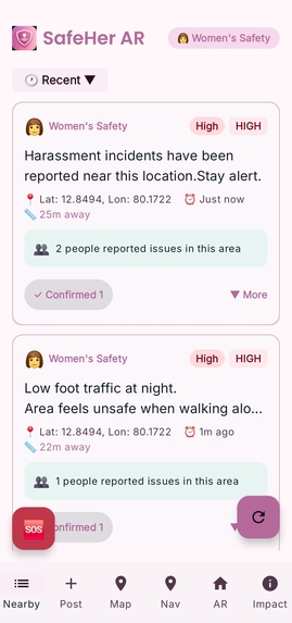
Nearby safety reports with severity levels and distance indicators for quick awareness.
-
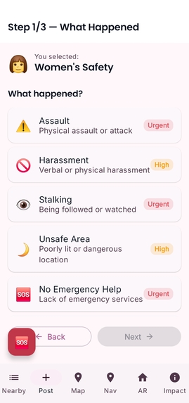
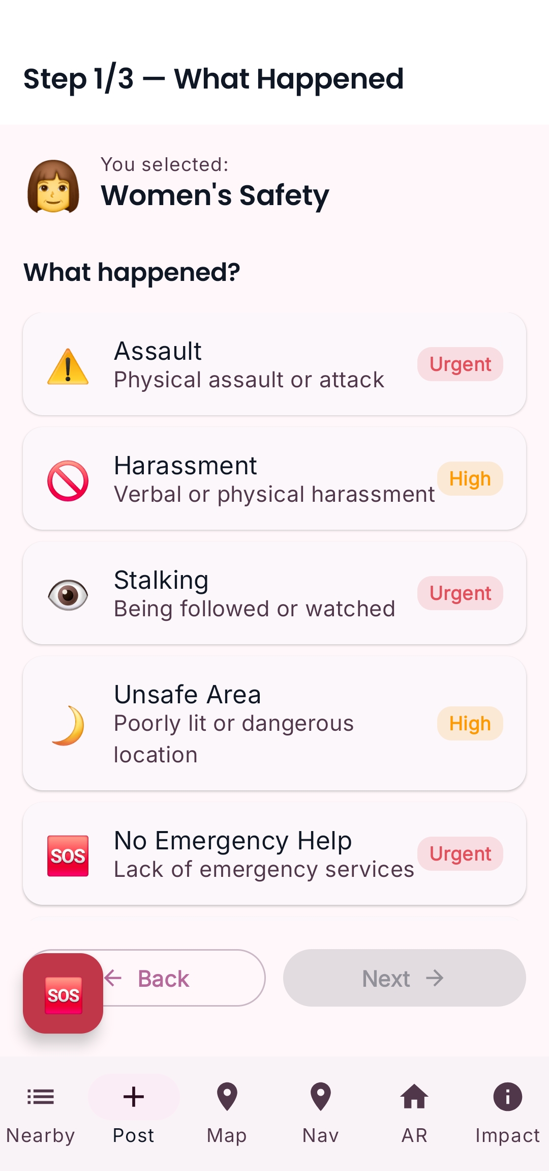
Simple interface to report incidents like harassment, stalking, or unsafe areas.
-
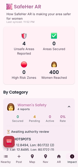
Dashboard showing community safety reports and the real-world impact of crowdsourced alerts.


SafeHer AR
Real-world safety visibility for women using Augmented Reality
The Problem
Women navigating cities — especially at night or alone — often experience reduced situational awareness while using traditional navigation apps.
Most navigation tools require users to constantly look down at a 2D map, dividing attention between the device and the physical environment. This creates a dangerous cognitive gap: the user may know the route but not the risks immediately surrounding them.
At the same time, hyper-local safety information such as harassment reports, poorly lit streets, or isolated areas is rarely available in real time.
As a result, women often lack the spatial awareness needed to make informed safety decisions while moving through unfamiliar environments.
Our Solution
SafeHer AR transforms safety information from a static map into a spatial augmented reality experience.
Instead of reading hazards on a map, users can see safety risks directly overlaid onto the real world through their phone camera.
Using Google ARCore’s Geospatial API and spatial anchors, the system locks safety markers to real-world coordinates so hazards appear exactly where they exist in the environment.
This approach preserves situational awareness while still delivering contextual safety intelligence.
Users can instantly understand:
- where risks are located
- how far they are
- how severe they are
without leaving the real-world view.
Key Features
AR Safety Overlay
Using ARCore spatial anchoring, safety reports are projected directly onto the real-world environment.
Markers remain stable relative to physical locations, enabling intuitive spatial awareness.
Community Safety Reporting
Users can anonymously report incidents such as harassment, stalking, unsafe areas, or lack of emergency services.
Reports are stored in Firebase Firestore and retrieved using geospatial queries so nearby hazards appear instantly.
Hands-Free Safety Alerts
When approaching high-risk zones, the system automatically triggers Text-to-Speech alerts and vibration feedback, allowing users to stay aware without looking at their phone.
Safety Risk Map
A dynamic map view aggregates community reports into color-coded risk zones, helping users quickly identify safer routes.
Impact Dashboard
An integrated dashboard shows how community participation improves collective safety awareness.
How We Built It
SafeHer AR combines several technologies to deliver a real-time spatial safety system.
Core Architecture
Frontend
- Jetpack Compose (Material 3)
AR System
- Google ARCore Geospatial API
- CameraX live camera pipeline
- SensorManager for device orientation
Backend
- Firebase Firestore for safety reports
- Firebase Authentication for anonymous validation
Location
- Google Play Services Location API
Accessibility
- Android Text-to-Speech for hands-free alerts
This architecture enables real-time spatial awareness with minimal friction for users.
The app loads nearby hazards through geospatial queries and anchors them into the environment using ARCore’s Earth-based coordinate system.
Engineering Challenges
Several technical challenges were encountered during development.
AR Marker Overlap
In dense hazard zones, markers could overlap and obscure each other.
To solve this, a custom radial collision algorithm was implemented to dynamically fan out overlapping markers while maintaining spatial relevance.
Performance Optimization
Initial versions experienced UI frame drops because anchor loading occurred on the main thread.
Heavy operations were moved to background IO threads and request debouncing was introduced to prevent redundant location queries.
Privacy Protection
Safety reporting systems risk exposing sensitive user data.
SafeHer AR was intentionally designed to be fully anonymous, storing only hazard data and timestamps without any personally identifiable information.
Evidence and Research
The design approach was informed by research in urban safety and human-computer interaction.
Research from UN Women’s Safe Cities initiative highlights the widespread safety challenges women face in public spaces.
Studies on situational awareness also show that constant downward attention toward mobile screens reduces environmental awareness.
Augmented reality overlays improve contextual understanding by integrating digital information directly into the user’s physical environment.
These insights informed the spatial AR design used in SafeHer AR.
Impact
SafeHer AR aims to improve safety awareness through community-driven intelligence and spatial computing.
By enabling users to report and visualize safety hazards in real time, the platform builds a shared layer of safety information across public environments.
The long-term vision is a world where anyone can instantly see the safety context of their surroundings and make informed decisions while navigating cities.
UN Sustainable Development Goals Alignment
The project aligns with the United Nations Sustainable Development Goals:
SDG 5 — Gender Equality
Empowering women with tools that improve safety, mobility, and confidence in public spaces.
SDG 11 — Sustainable Cities and Communities
Using community-driven data and spatial technology to help build safer, more inclusive urban environments.
What We Learned
This project reinforced the importance of combining technology with human-centered design.
Augmented reality is most powerful not as a visual novelty, but as a tool that improves how people understand and interact with their real environment.
By integrating AR with community reporting and accessibility features like hands-free alerts, SafeHer AR demonstrates how spatial computing can address real-world safety challenges.
Built for the #75HER Challenge
SafeHer AR was developed as part of the CreateHER Fest #75HER Challenge, focusing on solutions that empower women through technology.
The project emphasizes clarity, responsible engineering, accessibility, and meaningful real-world impact.
Built With
- arcore
- camerax
- firebase
- firestore
- google-play
- jetpackcompose
- kotlin
- sensormanager
- texttospeech


Log in or sign up for Devpost to join the conversation.