Inspiration
Our inspiration primarily comes from the catastrophic flooding in Ashville, NC caused by hurricane Helene. We wanted to learn more about how we could leverage data to identify and prevent future catastrophies and loss of life by analyizng disaster readiness of certain counties.
What it does
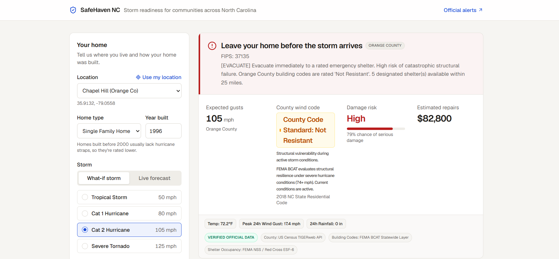
SafeHaven NC is a real-time natural disaster resilience and emergency shelter navigation platform built for North Carolina residents. It evaluates whether a user's home can withstand an incoming storm and, if not, automatically routes them to the nearest survivable emergency shelter.
How we built it
SafeHaven NC is a resilient, full-stack geospatial routing and structural risk assessment platform that remains operational during both blue-sky planning and severe disaster states. It features a multi-tier adaptive ingestion pipeline—cascading between live FEMA feeds, NC OneMap GIS, and offline statewide snapshots—to ensure continuous data access. The platform integrates FEMA's HAZUS methodology to model structural vulnerability and financial loss based on building codes and wind degradation, utilizes an adaptive concentric-ring routing algorithm with real-time weather integration to direct users to safe shelters, and is built using a modern Python/FastAPI backend and Next.js/Leaflet frontend.
Challenges we ran into
We thought that sourcing and analyzing dataset columns was our biggest challenge. For the problem we were trying to answer we spent a lot of time trying to analyze and find meaningful connections between dataset values. We found cleaning and converting dataaset values especially challenging.
Accomplishments that we're proud of
We are most proud of the tool and data cleaning/prepping we have done.
What we learned
Building SafeHaven NC taught us that real-world emergency management architectures must be designed around public sector operational realities rather than standard API conventions. We discovered that federal emergency layers like FEMA’s National Shelter System are strictly active incident feeds that stay completely empty outside declared disasters, requiring us to design an adaptive, multi-tier fallback pipeline that seamlessly bridges federal live feeds with NC OneMap’s 2,400+ designated state facility records. We also learned that public ArcGIS REST servers are prone to traffic spikes, rate limits, and 503 timeouts, demonstrating why life-safety applications must decouple boot sequences from external dependencies through offline-resilient local caching across all 100 North Carolina counties. Furthermore, implementing FEMA HAZUS-based damage curves revealed that physical disaster vulnerability is fundamentally non-linear, reinforcing how structural framing, home age, and county-level building code enforcement directly dictate whether an envelope withstands aerodynamic uplift. Finally, bridging these models into a modern Next.js and Leaflet interface underscored the necessity of defensive frontend event handling, particularly around sanitizing external navigation links and containing map event bubbling to avoid critical runtime crashes during high-stress user interactions.
What's next for SafeHaven
Looking ahead, our primary goal is to expand SafeHaven NC from a wind-and-shelter router into a comprehensive, multi-hazard evacuation suite. Our immediate technical milestone is integrating the FEMA National Flood Hazard Layer (NFHL) and NOAA storm surge models, enabling the risk engine to evaluate compounded structural threats from both high-velocity wind and coastal or riverine inundation. To address the severe network disruptions typical of hurricane landfalls, we plan to convert the frontend into an offline-first Progressive Web App (PWA) with service-worker caching, allowing residents to calculate vulnerability and navigate toward designated shelters using raw device GPS even when cell towers fail. Additionally, because the shortest straight-line path is useless if transit corridors are washed out, we aim to integrate live NC DOT (DriveNC) road closure and bridge hazard data to provide real-time, obstruction-aware routing. Over the long term, we envision rolling out dedicated dashboards for local Emergency Management Directors, empowering municipal officials to update facility intake capacities, medical supplies, and generator statuses in real time.
Built With
- and
- css3
- fastapi
- fema-bcat-api
- fema-national-shelter-system-api
- github-codespaces
- google-maps-directions-api
- html5
- httpx
- in-memory-ttl-caching
- json-flat-file-storage
- leaflet.js
- lucide-react
- nc-onemap-arcgis-mapserver
- next.js
- open-meteo-api
- pydantic
- python
- react
- react-leaflet
- render
- tailwind-css
- typescript
- us-census-tigerweb-api
- vercel


Log in or sign up for Devpost to join the conversation.