
Inspiration
The traffic has increased significantly over the past few decades which has led to an ever increasing rise in the number of road incidents. Reporting these incidents in real - time has become a necessity now more than ever. In 2010, the stats presented in the World Health Report (WHR) documented road traffic injuries as the ninth most common reason for the disability of people. According to the report by the World Health Organization (WHO), about 1.24 million casualties and 50 million injuries were reported globally. Out of these many incidents, only a few of them were reported as soon as they happened to the emergency contacts of the affected ones. This led to many deaths only because there was a delay in reporting, which could have been potentially avoided. So this led us to think of real-time reporting of incidents to the emergency contacts of the affected ones by using the INRIX incidents and routing APIs.
What it does
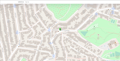
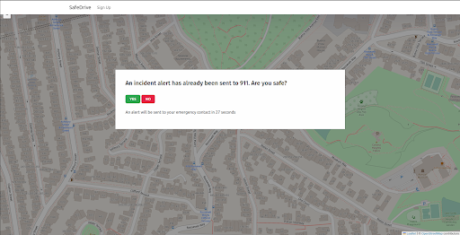
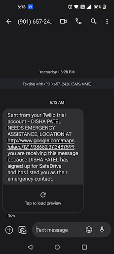
Given a user’s live location, our application continuously polls the location information. Now if there is a traffic incident which lies in the same radius then it is detected and a safety alert is raised to the user and their emergency contacts. If in case there is some unusual incident which might probably put our user in danger then the user is notified by an alert on the screen to which it is expected out of the user to respond. If the user responds that he is ‘Not Safe’ OR if the user doesn’t respond within the stipulated time then the emergency contacts fed in by the users are also alerted with the user's location and a message saying that the user might be in potential danger. Along with the above use case, our application also sends out the notification to 911 when the first time the incident is reported through the user. Furthermore, if there are any healthcare workers registered in our application then they are also notified about the incident by asking them if they can assist in any way possible.
How we built it
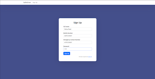
INRIX Incident and the Routing Apis are the core of our application. We divided ourselves into 2 teams to work on the front end and back end. For the front end we built an application using React for the user to register themselves with their and their emergency contact information. The map with user location is rendered using Leaflet. The website design is done using Bootstrap.The back end server long polls the user’s coordinates from the client app. Inrix’s Incident API provides near real-time traffic incident data, we used that information to detect accidents near the user coordinates. We use the computed severity of the incident and Inrix’s routing API to gauge when and whether to alert emergency contacts. If the user was detected to be in extremely close proximity to or was in the accident, the client application alerts the user asking if he is safe or not. We used Twilio API to send the SMS messages with the user’s location which are sent to the emergency contact.
Challenges we ran into
Initially, we faced difficulty in accessing the data from INRIX APIs because of its restricted access and changing authentication tokens. But we eventually found a way to refresh our tokens dynamically. Later on, during the development phase of our project, we ran into another issue while integrating the leaflet maps into our project. However, with the help of the hackathon mentor, we were able to resolve it in minutes.
Accomplishments that we're proud of
We are proud of the purpose that we have solved using technology. We were also excited to get hands-on experience of using API data, learning how to incorporate libraries of maps like Leaflet and messaging mechanisms like Twilio. Along with gaining technological experience, we also learnt how to improve collaboration while working as a team in this project.
What we learned
This hackathon helped us push the boundaries of our knowledge and skills in this field.. It gave us an opportunity to network with people and helped us enhance our soft skills. We also explored different APIs and were able to build ideas on real world applications which was an incredible learning experience.
What's next for SafeDrive
SafeDrive can be integrated as an add-on feature with google / apple maps. There is also a scope to forecast or guess the probability of an accident before it occurs using the historical data and analyzing the trends in the area having frequent incidents. Furthermore, keeping in mind the privacy and user consent, users can also provide some emergency medical information that can help in providing first aid to them.


Log in or sign up for Devpost to join the conversation.