Inspiration A map can draw a line from the library to the lecture hall. It still cannot tell you whether that line works this afternoon. The elevator has been out since Tuesday. Construction closed the sidewalk this morning. The door marked accessible locks at 6 pm. For a wheelchair user, and for anyone who would rather not walk into a dead end, “the path exists” is the wrong question. The question is whether you can actually get through it right now.
RouteWise is that missing layer. Every route carries a live belief, built from official closures, weather, what people report, and whether anyone has walked it lately, and the app says how sure it is.
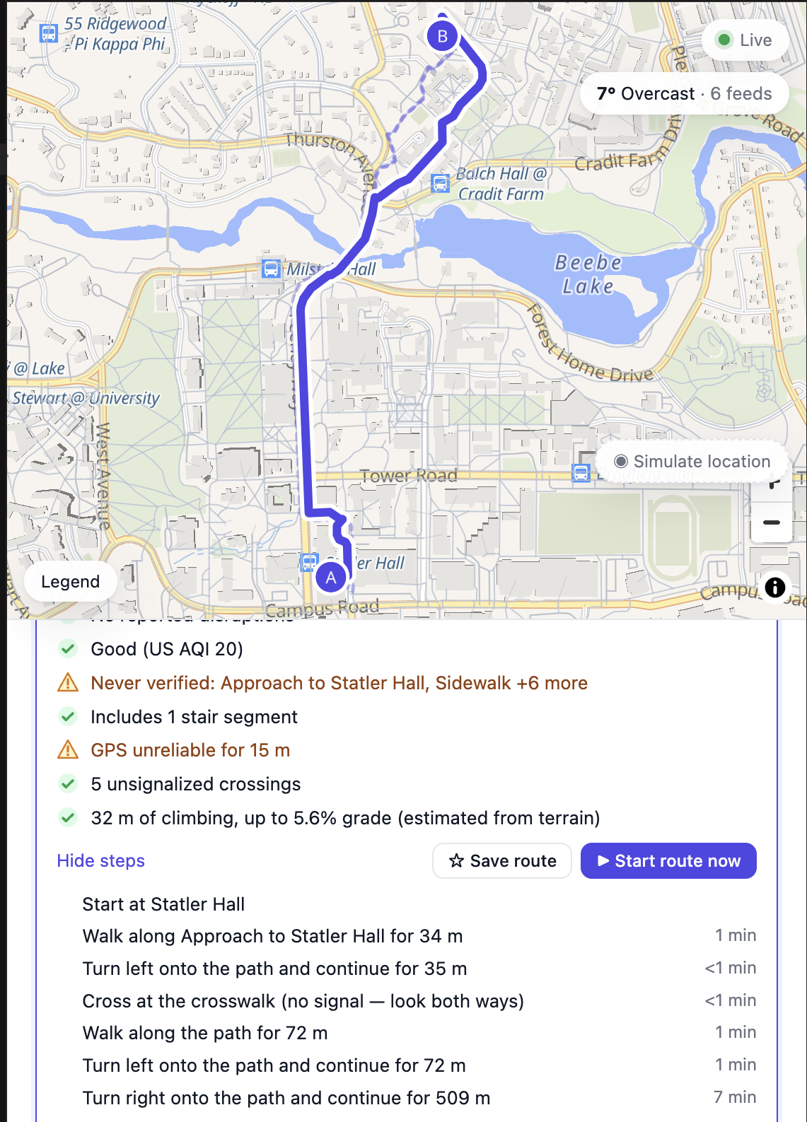
What it does RouteWise scores every route from 0 to 100% and shows the math. Confidence is passability × freshness × positioning, and Why 46%? lists the segments pulling each factor down.
You say who is travelling: fastest, most reliable, wheelchair, low vision, older adult, or cyclist. Hard constraints come first — no stairs, a running elevator, curb cuts, a slope limit — and only then does the router optimize time. Preferences cover cutting across lawns, cutting through public buildings while they are open, avoiding stairs, preferring lit paths after dark, and staying dry in the rain.
It runs on real places. About 65 universities are built in, any other place is a search away, and Near me loads the campus you are standing on. The walking network comes from OpenStreetMap. Live evidence comes from Open-Meteo (ice, snow, heavy rain, darkness), NYC street closures, MTA elevator outages, and WZDx work zones. A path nobody has observed stays unknown and fades back toward unknown if nobody reconfirms it.
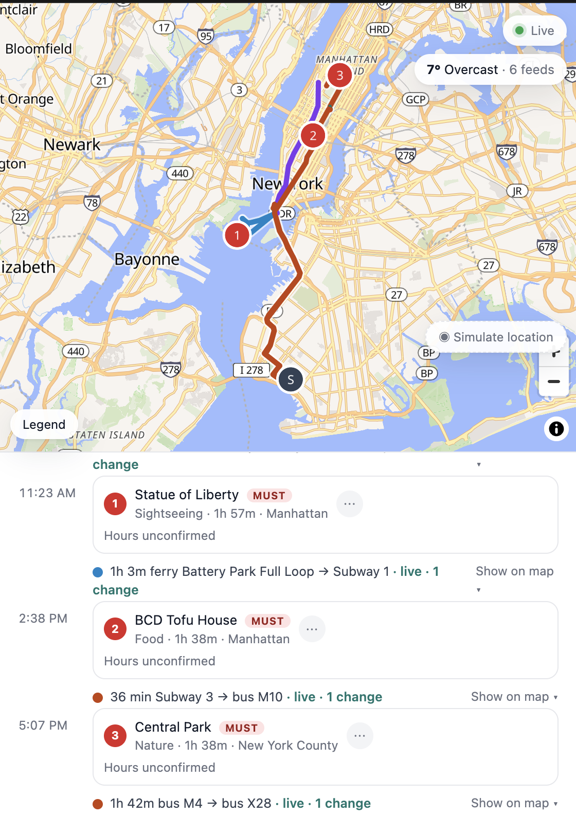
You can follow the route with spoken guidance, see an illustration of the turns and a short first-person walk-through, save a route and get alerted when its confidence or warnings change, and switch into Vacay mode to turn a messy list or a public Google Maps list into a multi-day itinerary whose walking legs use the same confidence engine.
How we built it Three TypeScript packages. core has no runtime dependencies: the graph, the evidence engine, the router, the OpenStreetMap importer, and the trip planner. server is a Fastify API with one world per campus, live feeds, and server-sent events that push only the segments whose state changed. web is React, Vite, and MapLibre.
Evidence is the center of it. Reports decay on a half-life that matches the problem: crowding fades in about 20 minutes, a closure in hours, construction in about a day. Independent reports combine with noisy-OR, so several weak reports add up and one person cannot close a path by tapping twice. A clearance counts only when it is newer than the newest blockage. Phones map-match GPS on the device and upload anonymous segment events — passed through, turned back, stopped, lost GPS — and never a trajectory. Three turnarounds in a short window, outnumbering successful passes since the trouble started, raise an anomaly and the map asks someone to confirm.
Trips that leave the mapped area go to Valhalla and are map-matched back, so the part inside the area still carries live confidence. Grades OpenStreetMap never tagged come from the Copernicus elevation model and become speed with Tobler’s hiking function.
Challenges we ran into The hardest design choice was staying honest when we had no observations. A freshly imported campus opens around 55–65% and says Never verified. That number looks worse than a normal map, and it is the true one.
Combining evidence so it could not cancel itself took the longest. People walking through a path before a closure say nothing about whether it is open now. Official feeds publish a street centerline and an end date, so a closure is attached only when a segment runs along it, roughly parallel, and on the same named street. Those feed items keep full weight until they lapse, and they never count as someone having observed the path.
OpenStreetMap is uneven. Wheelchair tags, kerbs, lighting, and inclines are missing on most ways, and a 90-meter elevation model is too coarse to enforce a slope limit without slack. The free elevation API counts every coordinate against a shared daily quota, so terrain is sampled on roughly 45-meter cells and nearby areas share one weather reading.
Importing a campus from Overpass, caching the raw response, and still rebuilding the graph when the importer changes — without re-downloading the city — was its own problem, as was treating two addresses in different neighborhoods as one continuous trip.
Accomplishments that we're proud of The confidence number is a formula you can read. Passability, freshness, and positioning each have a bar, a one-line reason, and a link to the segment responsible.
The same engine runs a scripted demo, where simulated travelers turn around at a silent blockage and the map asks “Is this path blocked?”, and real campuses from Binghamton to Tokyo. A wheelchair route will leave a broken elevator, take the step-free way, including a bridge nobody has verified, and say so on the card.
Privacy sits in the data model. The phone keeps the GPS trace and shares only what happened on a segment.
Vacay mode, spoken turn-by-turn guidance, and the illustrated walk-through all use that same route, so a weekend itinerary and a walk across campus are one system.
What we learned A route people will trust has to show its work. “46%” means something when the app can point at the unverified skybridge or the elevator that is out.
Unknown is its own state. Treating missing data as “open” is how an accessible route fails in the real world.
Official data and lived experience answer different questions, and time is the tie-breaker. A city feed knows a block is shut until Friday. A turnaround knows someone could not get through. Neither one, alone, is the route.
Pedestrian data is still thin. The walking graph is there. The tags that say step-free, lit, or “this door locks at night” usually are not, which is why a confidence layer has work to do beyond drawing the shortest path.
What's next for RouteWise Evidence still lives in JSON files and is recomputed on a timer. Next is a spatial database and incremental state, so a city-scale map can push a change without re-scoring every segment.
Indoor maps, so a route can end at a room. University facilities feeds that today exist only as a web page. The “is this path blocked?” prompt should reach someone who is actually nearby. Reporters should carry reputation when reports disagree. Paths should learn the time of day: doors that lock at night, routes that exist only in summer.
Built With
- api
- claude
- cursor
- typescript
