-
-
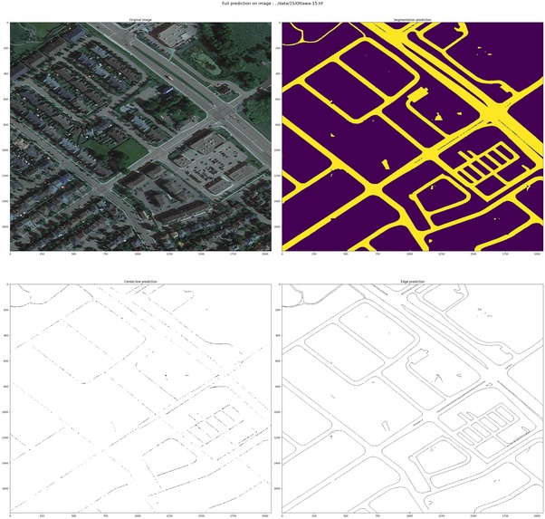
RoadNet segmentation applied on google earth image

Inspiration
In recent years, researches on road segmentation has been increasingly noticed in academia because of its applicability in the real world. For example, with a well-trained automated road segmentation model, an Automated Driving System (ADS) can automatically sort out the surrounding traffic and drivable regions, or it can be applied on remote sensing images to supervise the road system of an area to help with construction planning, traffic management,... and the list go on. Traditional camera-based road segmentation method employed the predefined features such as edges and corners to perform segmentation. These features, however is not robust enough and performs poorly in new scenarios. Therefore, in this project, I will develop a simple platform that perform segmentation on images from Bing Map images using Deep Learning models.
What it does
The platform provides users with a simple map interface (developed using React and Open Layers map library). The user can freely choose a region on the map and with a simple click, the map image will be forwarded to the API and the API will forward the image to a computing cloud to perform segmentation and return the segmented road areas to the user.
How we built it
Phase 1 : Training the RoadNet model: In this phase, we will focus on building the architecture of our CNN model that will be responsible for extracting road segmentation from remote sensing images. The deep learning framework that we will use is Tensorflow 2.3.1.
Phase 2 : Building the API: The API will be responsible for handling user's request from the interface to the computing server. The API will be developed using Python FLask framework.
Phase 3 : Building the user interface: The user interface will mainly include of the Bing Map interface (imported using Open Layer library in NodeJS). The interface will include functionalities like : Finding location be coordinates, countries and automatically displaying current coordinates as the user navigates.
Overall project structure

Challenges we ran into
- Since a deep learning model requires a huge amount of time to train and consists of data collection and cleaning, we will barely have time for phase 2 and phase 3 of the project in just one day of development.
- The dataset and the map data that we use for actual demo differs in lighting situations, therefore the output of the CNN model is highly distorted.
- All team members are not familiar with some of the technical details (like flask and open layer)
Accomplishments that we're proud of
- We are proud that we have made it here, that's all T-T
What we learned
- Building a CNN model with Tensorflow 2.x and building custom loss function for training neural network.
- Building a simple user interface with Open Layer and ReactJS.
- System engineering.
What's next for Road Segmentation using remote sensing images
The Road Segmentation using CNN model is definitely not a state of the art model for this problem. Therefore, the next thing that we can do to improve this project is to try it out with other models that we can find on arxiv.


Log in or sign up for Devpost to join the conversation.