-
-

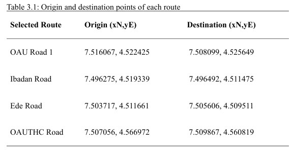
Origin and Destination Points of Selected Roadways
-
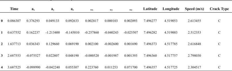
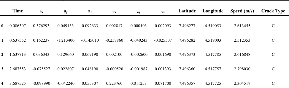
Roadway Dataset
Development of a Road Condition Classification Model Using Mobile Phone Sensors
What inspired me? Every bump on the road tells a story of missed opportunities, costly delays, and sometimes, tragic accidents. While commuting through the aged roads of Ile-Ife, I saw firsthand how under-maintained infrastructure chips away at economic potential and public safety. Nigeria reportedly loses over $6.2 billion annually to poor roads. The idea that stuck with me was this: What if your phone could help fix your roads?
That became my mission—to build a system that empowers everyday road users to become contributors to smarter infrastructure.
How I built this Armed with just a Samsung Galaxy A51 smartphone, a Toyota Camry, and a vision, I developed a machine learning model capable of identifying road defects like potholes, longitudinal cracks, and crocodile cracks. The project followed this journey:
📥 Data Collection: I used the Physics Toolbox Accelerometer to gather high-frequency sensor data (200Hz) while driving across 4 roads in Ile-Ife. GPS coordinates were logged every meter for validation.
🧹 Preprocessing: Resampled the data to align with ground-truth labels, handled overlapping defect zones, and addressed class imbalance, especially with underrepresented potholes.
🧠 Modeling: I trained a Random Forest Classifier using six core features; linear acceleration (ax, ay, az) and angular velocity (wx, wy, wz) achieving 77% accuracy.
🔍 Key Insights: Features like ax, az, wx, wz, and vehicle speed were strong predictors. Surprisingly, ay and wy had low impact—an orientation insight I hadn’t anticipated.
Challenges I faced
Vehicle bias: Using just one car meant the suspension system could skew results. Generalizing this required careful control and is a future enhancement area.
Class imbalance: Potholes were underrepresented, which hurt model recall. Gathering more diverse samples is on the roadmap.
GPS accuracy: Some crack types occur in small, localized areas, standard GPS couldn’t always pinpoint them precisely. A higher-resolution GPS module is vital for future work.
Multimodal limitations: Realizing that “feel” alone isn’t enough, I plan to integrate image-based recognition to give the model visual perception.
What I learned
Innovation doesn’t always require expensive hardware; it's about how creatively you use what's already in your pocket.
Real-world deployment forces you to think beyond models: data quality, device variation, GPS errors, and user experience all matter just as much.
Civic tech can empower communities. I envision a mobile app where road users earn “Road Credits” for collecting data, enabling a crowdsourced infrastructure revolution.
What’s next?
📲 Launching a public-facing mobile app
🧠 Adding image-based deep learning for multimodal detection
🤝 Partnering with transport authorities for real-world scaling
🌍 Expanding the dataset to cover more road types across Nigeria
This project is more than a classifier; it's a blueprint for how mobile technology can democratize public infrastructure monitoring.


Log in or sign up for Devpost to join the conversation.