-
-
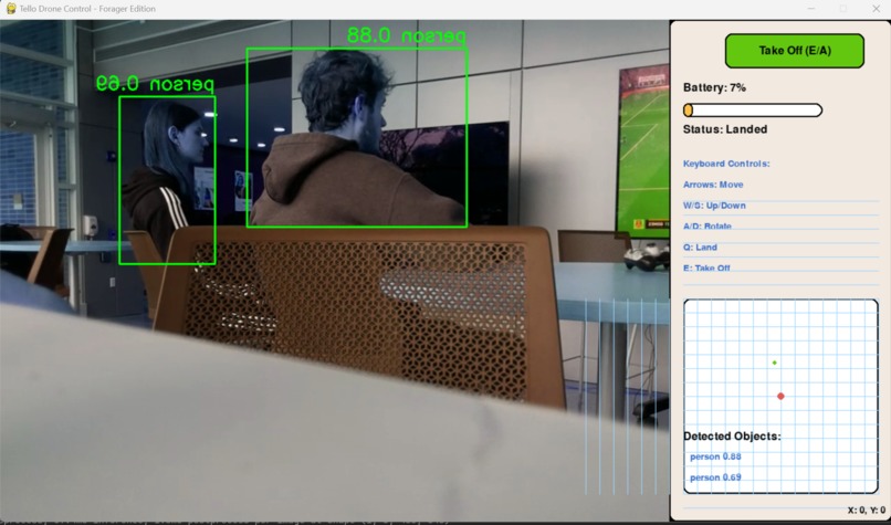
Generative AI locates individuals who could potentially be in a threatening scenario
-
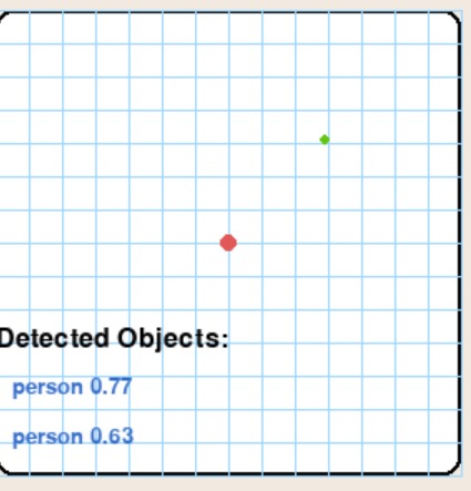
Custom mapping GUI allows us to know the location of the drone and at-risk people without GPS technology
-
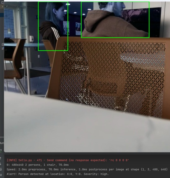
Live coordinates for at-risk people. Allows for emergency responders to know exactly where to go during the aftermath of a disaster.


Inspiration
The recent tragic events of Hurricane Helene and Hurricane Miltion left thousands of people in danger in the areas affected by these natural disasters. People were trapped in their homes, some on rooftops, awaiting rescue as rising waters engulfed neighborhoods. In rural areas, landslides blocked access routes, preventing emergency services from reaching those in need. In the aftermath, there was an urgent need to locate and rescue people in remote or heavily affected areas, making the deployment of advanced technologies like drones and AI critical to the relief efforts. This dangerous, chaotic environment inspired the development of the app, aimed at using drone imagery and AI chatbots to identify and respond to people in need faster and more efficiently. Therefore, we wanted to leverage innovative technologies to fight these more damaging storms.
What it does
RescueVision revolutionizes hurricane response efforts by deploying drones to scan affected areas. Using AI and image recognition, the app swiftly identifies individuals in distress, assessing their risk levels and creating real-time maps of survivor locations. It prioritizes rescue missions based on urgency and provides emergency teams with optimal routes to reach those in need. The app continuously monitors changing conditions, updating rescue priorities accordingly. RescueVision seamlessly integrates with existing emergency response systems, offering a user-friendly interface for rescue coordinators to manage operations efficiently. After each mission, it generates comprehensive reports, enabling continuous improvement of rescue strategies and data for future model training.
How we built it
We leveraged the power of the Real-Time Object Detection library YOLO in conjunction with the impressive capabilities of Ryze Tello drones. The entire tech stack is programmed in Python from backend functionality to UI elements.
Challenges we ran into
For many of us, it was the first time working with external hardware for a programming project. Therefore, many challenges came up to us in the middle of the process that we were not expecting.
One challenge we faced was that the drones were capturing various objects, not just people, so we had to focus on refining the system to recognize only humans.
We initially decided to implement automated flight capabilities for the drones to enhance their efficiency. However, this approach led to system crashes and ultimately resulted in the destruction of one of our drones. Consequently, we made the decision to forgo this feature in our project to ensure stability and reliability in our operations.
Another problem was that for the program to send SMS alerts to rescue teams, it needed to accurately pinpoint the location of people in distress. However, we did not have a GPS to make this work. Therefore, we had to build a mapping system that recognizes where the drone is and pinpoint the exact location of the recognized people.
Furthermore, the drones used for testing our project were not ideal for our needs. Although they operated efficiently, the cameras were not positioned for downward-facing views. To overcome this limitation, we were going to us a 3D printed custom model with a strategically placed mirror, enabling the cameras to capture images of people on the ground. However, the 3D Printing was taking too long to complete the printing, not allowing us to align the drones more closely with our project’s objectives despite the initial hardware constraints.
Accomplishments that we're proud of
We are proud of our team's accomplishments, including the successful development of an innovative drone system that enhances disaster response capabilities. Our collaborative efforts allowed us to leverage diverse skills and perspectives, fostering a cohesive environment that contributed to our success. We gained valuable hands-on experience in drone technology, AI algorithms, and image recognition systems, significantly improving our technical proficiency. Additionally, our project aims to make a real-world impact by contributing to the safety and well-being of our community and presenting positions for future recognition and opportunities within the tech community.
What we learned
We achieved several important milestones as a team. We enhanced our skills in AI-driven image recognition and real-time data processing, while also improving our collective problem-solving and project management abilities. Together, we developed an innovative tool that can make a significant difference in disaster response, contributing to saving lives by refining how drones detect people in emergencies. As a team, we navigated the ethical and legal challenges to ensure the responsible use of AI, while collaborating across disciplines to broaden our professional network. Ultimately, this project not only sharpened our technical expertise but also allowed us to make a meaningful impact on society, helping us grow both as a team and as individuals.
What's next for RescueVision
The next steps for RescueVision are incredibly exciting. Our team is committed to enhancing the efficiency of this project, continually refining our approach to maximize its impact. We also aim to implement GPS vision and swarm coding to improve coordination among drones during operations. We plan to present our initiative at this year's Nittany AI Challenge, where we hope to showcase the potential of our solution and demonstrate the difference we can make in our community. This opportunity will not only allow us to gain valuable feedback but also to connect with other innovators dedicated to leveraging technology for social good.

Log in or sign up for Devpost to join the conversation.