

Tracks
- Type 1: Purpose | Protecting and Restoring the Environment
- Type 2: Technology | Best use of an ArcGIS Maps SDK
Inspiration
The ongoing energy crisis and rising global temperature levels require climate action. Some of us acknowledge the issue at hand, and some do something about it, resulting in a growing number of engaged players and greater funding to support climate action. Still, finding initiatives that match your interests remains challenging.
A lack of centralized spaces for climate initiatives, unclear and at times, disorganized communications from climate organizations, and limited visual representation of progress are just some of the barriers people face when looking for climate initiatives they could support.
About (what it is)
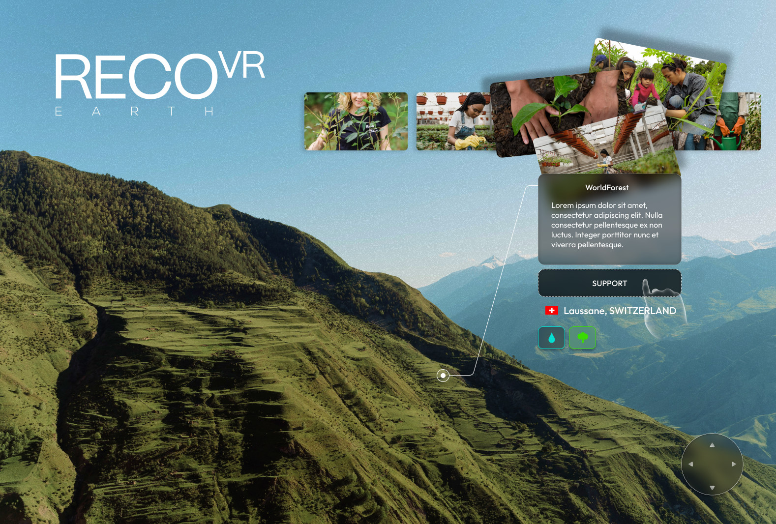
recoVR is an immersive data visualization project for localized climate action efforts that present data in an informative and engaging way. We are on a mission to help individuals and organizations discover climate efforts they could support, collect and highlight data discrepancies between affected areas and support efforts, and increase climate change awareness through VR.
Watch as the data come to life and find organizations and communities you can engage with in an immersive and gamified way. Let’s recoVR the earth together!
Who is it for
- For VR users, recoVR is a tool that helps understand localized climate issues, as well as learn and support organizations working to resolve them
- For climate action communities and startups, recoVR will be a Marketing Vehicle as well as a market research tool to quickly find other organizations interested in solving the same climate problems.
- For climate action funds, advocates and policymakers, recoVR is a reference resource that helps identify areas with excess or minimal support and investment. It also helps them understand and evaluate progress initiatives they invest in, make or fail to make.
How it works
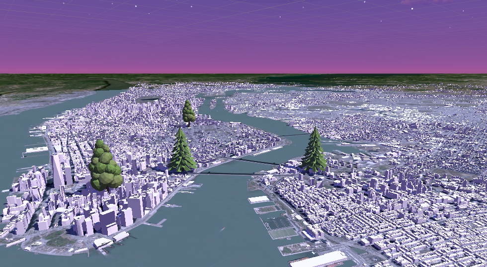
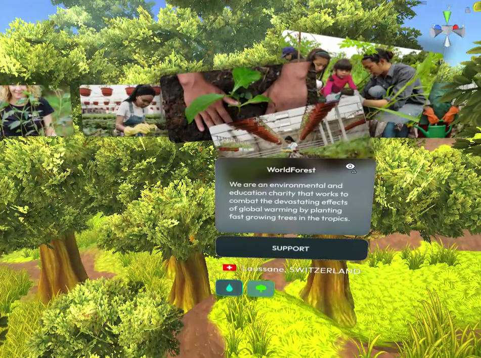
No login is required, any user can move around the map, see distinct climate-related layers, and zoom into the earth to find localized efforts in problem areas. They can then learn about the organizations working on those issues and follow the link to support them.
Demo v.2 would be deforestation and reforestation, drought and irrigation, trash piles, and cleanup efforts. Users see a map that features real-world data relevant to each specific use case.
Challenges
- ArchGIS comes with a Unity SDK that is majorly centered on VR. However because of the size optimization of the geo data, the motion of the camera is restricted to a certain behavior that conflicts with our experience design. We found a way to let these two systems coexist with some customized solutions that enable and disable components of ArchGIS and the OVR rig strategically.
- We had some issues in the android adaptation of the package. For example, the android manifest required some extra package enforcement.
- A member of the team had some issues because the SDK didn’t support Apple Silicon M1 Chip and the respective unity version.
- We also adapted a newer version of ArchGIS to an older Augmented Reality device (Magic Leap One).
- However, the deployment was only visible via the simulator (Zero Iteration) and not via Lumin Deployment. ArchGIS does not support layers.
- Data! Finding up-to-date, accurate and robust data sets similar parameters and getting it on the map. We used a large data set and cut specific locations and parameters out of it for demo purposes. Part of the future development would entail data collection through manual entry and affiliate marketing with activist organizations, UGC, and partner research organizations.
- Last but not least, we have pivoted three times from full-scale ideas. While always remaining in CleanTech and wanting to implement ArchGIS, this idea came to us on the morning of day two, and the core development streak started at 7 pm. Our team almost gave up on the idea as a whole due to technological difficulties, but thankfully we have recoVRed!
Our team
Jingyuan Li — developer. Sihan Zhang — developer. Adam Sauer — lead developer. Anna Gayete — user experience, user interface, branding. Dana M — strategy, idea validation, PM, copy.
Future Developments
- Core Tech Dev: Custom input/output ArcGIS APIs, Scanning 3D environment meshes for problem areas (e.g. deforestation/drought, etc), building users server
- Features: adding layers of the climate-related date such as deforestation maps, carbon pollution heat maps, drought maps etc., adding climate cause preferences, search bar for locations or climate action types, interactive 3D version/create XR or cross-platform experience, adding a comment or community component to promote engagement with users in VR, AR or web. Adding an ability to allow UGC — anyone could upload a 2D photo of a climate issue near them and its progress, this upload could be done on the web but also seen in VR with exact photo coordinates reflected accordingly on the VR map.
- User Testing: conduct in-depth user research and usability studies e.g Interview, survey and A/B test VR users (regardless of interest in climate action) - for POC, UI and UX input, interview climate action organizations sign up flow, sign up parameters etc.
- Develop a user case study to analyze challenges, pros/cons, benefits, disadvantages/advantages for integrating into the current markets, ie, overcome adoption issues, education training, costs/pricing, etc
- Business Dev: Finalize business plan, incorporate, build an advisory board, pitch to investors or look into acquisition possibilities.
- Since the deployment on AOSP is "limited" by the manual inclusion of binary files, so building OpenSSL from source, we had some challenges in building .apks. It would be helpful deep dive into the deployment of apps on android devices prevalent across the ecosystem that allows XR visualization.
Let's recoVR the earth together!


Log in or sign up for Devpost to join the conversation.