-
-
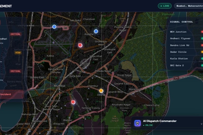
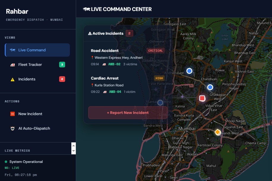
The Rahbar Command Center: A live, real-time dashboard tracking city emergencies and the active ambulance fleet.
-

Rahbar Dashboard: Tracking active emergencies and fleet positioning in real-time across the Mumbai metropolitan zone.
-

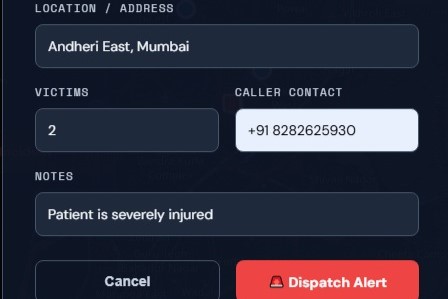
Rapid Incident Reporting: A fully interactive interface allowing operators to instantly log and categorize new city emergencies.
-
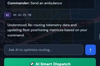
Smart AI Assistant: Dispatchers can manage the entire fleet and optimize routing using simple text commands.


Inspiration
Every minute an ambulance is delayed in traffic, the patient's chance of survival drops by up to 10%. While consumer GPS apps are great for finding the shortest route for a commute, they are completely inadequate for emergency responders because they are passive; they guide cars into traffic rather than moving traffic out of the way. We were inspired to bridge the gap between urban infrastructure and emergency logistics. We wanted to shift from passive monitoring to active management by giving ambulances a "digital escort" through the city.
What it does
Rahbar is a Smart City IoT Command Center designed to actively reduce emergency response times. It provides a high-fidelity geospatial dashboard that tracks active emergency fleets and live traffic incidents. When an emergency is declared, Rahbar utilizes a dynamic pathfinding algorithm. Instead of just finding the shortest distance, it calculates the "Time-to-Life" route by treating the city as a weighted graph where traffic density equals cost. The system then simulates a "Green Wave", the concept of pre-clearing traffic lights and rerouting civilian traffic ahead of the ambulance, instantly visualizing the optimized route on a real-world map and calculating the critical minutes saved.
How we built it
We engineered Rahbar as a full-stack, server-client application to ensure maximum performance and scalability: Backend: We built a high-performance RESTful API using Python and FastAPI. This backend acts as the city's central nervous system, holding geospatial data, simulating IoT telemetry, and executing the dynamic routing logic.
Frontend: We bypassed heavy frameworks and used pure Vanilla JavaScript, HTML5, and CSS3 to ensure zero latency. We implemented a stunning, dark-mode glassmorphism UI to mimic an enterprise-grade command center.
Geospatial Mapping: We integrated Leaflet.js and OpenStreetMap to render interactive, real-world coordinates, allowing us to draw dynamic polylines and markers without relying on expensive, rate-limited mapping APIs.
Challenges we ran into
Building a full-stack geospatial app under tight hackathon time constraints pushed us to our limits.
Environment Configuration: We faced significant hurdles getting the Python backend, Uvicorn server, and Windows environment variables to play nicely together while dealing with CORS (Cross-Origin Resource Sharing) policies blocking our frontend.
Mapping Real Data: Translating conceptual routing logic into actual latitude and longitude coordinates that render correctly on a Leaflet map required deep dives into geospatial documentation.
UI/UX Balance: Designing an interface that displays complex data (fleet status, traffic density, and system metrics) without overwhelming the user was a tough design challenge. We had to iterate quickly to achieve the clean "Command Center" aesthetic.
Accomplishments that we're proud of
A True Full-Stack Prototype: We didn't just build a visual mockup; we successfully connected a dynamic frontend to a functioning Python backend server.
The UI/UX: The dashboard looks incredibly professional. The sleek design, interactive map, and real-time metric updates make for a flawless live demo.
Solving a Real Problem: We built something that actually matters. Applying graph theory and pathfinding algorithms to a real-world, life-or-death problem is something we are deeply proud of.
What we learned
This hackathon was a massive learning experience. We leveled up our backend engineering skills by deploying FastAPI. On the frontend, we mastered Leaflet.js for interactive mapping and learned how to manage asynchronous JavaScript [fetch] calls to keep the UI perfectly synced with the server. Most importantly, we learned that sometimes the best solution isn't adding more complex AI but using existing algorithms (like pathfinding) in a highly creative, impactful way.
What's next for Rahbar
This prototype proves the concept, but the vision for Rahbar is massive. Next, we plan to:
Ingest Real-Time City Data: Integrate with live municipal APIs (like Google Maps Traffic or city-owned IoT sensors) to replace our simulated data with real-world congestion metrics.
Machine Learning Integration: Train a model to predict traffic bottlenecks before they happen based on time of day, weather, and local events.
Driver Companion App: Build a lightweight mobile app for the ambulance drivers that syncs with the Command Center, giving them turn-by-turn "Green Wave" navigation.

Log in or sign up for Devpost to join the conversation.