-
-
Dashboard v1

Inspiration
When a disaster or geopolitical shock hits, the immediate physical damage is only half the story. The true humanitarian crisis often unfolds days or weeks later, when global supply chains shatter and vulnerable communities run out of Macro-Lifelines—LPG, diesel, medicine, and wheat.
We noticed a massive gap in the AI landscape: predictive logistics are almost exclusively built for corporate profit optimization or defense, not civic infrastructure. Furthermore, traditional systems are reactive; they report shortages when shelves are already empty.
We built PulseNet to change this. We wanted to create a predictive decision-support system that shrinks the window between a physical shock and a logistical response, protecting the communities that have the least slack to absorb a disruption.
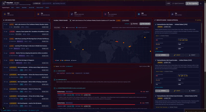
What it does
PulseNet predicts where the next critical resource shortage will hit before it happens, and hands an emergency administrator a transparent, one-click way to mitigate it.
It operates via a three-layer architecture:
Live Ingestion: Pulls real-time data from global APIs and local news feeds, using AI to extract the structural severity of a crisis.
Graph Reasoning & Ripple Evaluation: Maps the disaster against global trade dependencies to find downstream vulnerabilities.
The Reroute Queue (HITL): Suggests mathematically optimized alternative supply routes for human approval.
How we built it
We engineered PulseNet to strictly separate AI reasoning from hard mathematics:
Unstructured Extraction (The AI): We used the Gemini API to process chaotic, unstructured live feeds from USGS, GDACS, ACLED, and RSS feeds across 20 countries. The LLM extracts the event type, location, severity, and impacted commodities.
Deterministic Math (The Engine): We actively prevented the AI from "guessing" the logistical impact. Instead, we pipe the extracted data into a custom Ripple Evaluator. This engine uses a SQLite database (via Prisma) containing trade graphs to calculate exposure. We run Monte Carlo simulations to output the median triage window and the 95th-percentile worst-case scenario.
Responsible AI & Equity: We built a
monitoringDensityschema parameter. If an event occurs in a developing, under-monitored region, the system mathematically penalizes its own confidence score to ensure human reviewers are explicitly warned about potential blind spots.
The systemic confidence \( C \) of any downstream shortage (Node \( n \)) is calculated recursively, penalized by our equity metric:
$$ C_n = \left( \prod_{i=1}^{n} P(\text{Node}i \mid \text{Node}{i-1}) \right) \times \text{monitoringDensity} $$
Challenges we ran into
The "No Data = No Risk" Fallacy: Standard AI models assume that if a region lacks digital reporting infrastructure, there is no crisis. We overcame this by building the aforementioned
monitoringDensitymetric into the core schema, forcing the UI to flag under-monitored regions rather than ignoring them.AI Hallucinations in High-Stakes Environments: Early iterations of the LLM exaggerated global conflicts or suggested unrealistic reroutes. We solved this by implementing a Maximum-Friction Mandate. We restricted the LLM to only parsing input text, offloading all probability routing and supply-chain logic to deterministic Python/TypeScript mathematical functions.
Strict Human-in-the-Loop Integration: We had to ensure the AI could never act autonomously. We built a strict architectural boundary where the AI outputs to a "Reroute Queue" and stops. A human must manually authorize it, which then writes an immutable record to the Systemic Audit Ledger.
What we learned
We learned that in civic tech and disaster response, AI should extract, math should predict, and humans must decide. We discovered that framing AI limitations (like worst-case bias) as intentional architectural constraints (stress-testing) fundamentally shifts the system from a fragile automated bot into a robust, realistic decision-support tool for government officials.
What's next for PulseNet
We plan to expand our SQLite trade graph to include hyper-local municipal data, integrate real-time satellite imagery APIs for physical infrastructure verification, and deploy the dashboard as a Progressive Web App (PWA) so on-the-ground administrators can access cached supply chain data even when local internet infrastructure fails.

Log in or sign up for Devpost to join the conversation.