- Tracking GPS location of every citizen with a smartphone.
- Will require data subsidies for low income individuals.
- Store this data under doctor patient confidentiality for privacy concerns.
- Does not require devices to be online continuously, but be on with GPS continuously.
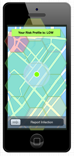
- Allow users to report their infection status.
- Additionally allow early (un-tested) reporting of self-diagnosed symptoms.
- Allow hospitals to report any citizens' infection status.
- Obtain degrees of separation using social media friends list or mobile phone contacts.
- With the aforementioned data sets we can do a number of things:
- Calculate probabilities of infection based on degrees of proximity to individuals who have been reported as having Corona, or even potentially having Corona.
- Provide a risk profile of active users.
- Back propagate the path of infection using historical GPS location data.
- This allows the system to generate a real time risk profile per individual.
- With this risk profile process such as the following can be implemented:
- Restriction to public spaces.
- Restriction of travel.
- Early testing and treatment of individuals who were in degrees of proximity.
- Identify non-compliant members of the public to deploy additional enforcement.
- Additionally this risk profile is available between private individuals and their contacts, which will enable users to use their discretion when meeting with others.
Built With
- google-maps
- graphql
- https://github.com/uber/h3
- material
- react-native


Log in or sign up for Devpost to join the conversation.