1. Project Title
PathAble: The Living Accessibility Map
Tagline: Because the shortest route is not always a possible route.
- PathAble is a community-driven accessibility intelligence platform designed to make urban navigation genuinely usable for wheelchair users and people with mobility-related accessibility needs.
- It combines personalized navigation, geospatial computing, accessibility data, community intelligence, machine learning, and urban analytics to determine not simply where a person can travel, but whether a journey is realistically possible for them.
- The platform is designed to support both individuals who need reliable accessibility information before travelling and institutions that need to understand and address accessibility gaps across their environments.
2. Theme
Primary Theme: Social Impact & Community Innovation
- PathAble addresses a fundamental problem of inclusion: the ability to move independently through the world should not depend on whether a person can physically overcome the barriers placed in their path.
- For many wheelchair users, planning a simple journey can involve uncertainty that other people rarely have to consider. A destination may be accessible, but the route to it may not be. A building may have an accessible entrance, but that entrance may be on the opposite side of the building. A ramp may exist, but it may be blocked. An elevator may be essential to the journey, but unavailable when the person arrives.
- These experiences can turn ordinary activities such as attending a class, reaching a workplace, visiting a hospital, meeting friends, or using public transport into journeys requiring extensive planning, assistance, and risk.
- PathAble aims to reduce this uncertainty by making accessibility a first-class component of navigation, rather than an afterthought added to conventional maps.
- While rooted in Social Impact & Community Innovation, PathAble creates an interdisciplinary bridge to Architecture & Urban Innovation by translating citizen barrier data directly into municipal capital improvement projects, and to Healthcare & Wellbeing by removing the systemic travel anxiety and physical hazards that lead to social isolation.
- PathAble is intentionally conceived as a service and community framework, not merely as a software product. Its value comes from connecting people who experience accessibility barriers, communities that can contribute local knowledge, and institutions responsible for maintaining public infrastructure.
- The proposed service can establish a continuous relationship between citizen experience, community verification, institutional response, and measurable urban improvement, ensuring that accessibility becomes an ongoing civic responsibility rather than a one-time infrastructure assessment.
3. Problem Statement
- Conventional navigation systems generally optimize for distance, travel time, traffic, and road connectivity. They answer the question, “How quickly can I get there?” but often fail to answer the more important question for a wheelchair user: “Can I actually get there using this route?”
- Consider a journey that appears to be only ten minutes away. A wheelchair user may reach a staircase and have no alternative route. They may encounter a pavement that is too damaged to cross safely. A dropped kerb may be missing at the road crossing. A supposedly accessible entrance may be blocked by parked vehicles. An elevator may be out of service, leaving an otherwise accessible building unreachable.
- What appears to be a small infrastructure problem to one person can completely terminate the journey for another. A staircase is not a minor inconvenience when stairs are physically impossible to use. An inaccessible crossing is not a small detour when it forces a person into moving traffic. A broken elevator is not merely a maintenance issue when it is the only connection between two floors.
- This creates a form of uncertainty that affects everyday independence. Users may have to call venues in advance, ask strangers for assistance, depend on caregivers, arrive significantly earlier to account for possible obstacles, or abandon a destination altogether.
- The problem becomes even more serious when accessibility information is static, incomplete, outdated, or distributed across different sources. A map may say that a location is accessible because an accessible facility exists there, while providing no indication that the facility is currently unusable.
- Accessibility is also not universal. A route that works for one wheelchair user may not work for another because of differences in wheelchair type, acceptable slope, pathway width, strength, balance, or dependence on elevators and ramps.
- As a result, there is a significant gap between mapped connectivity and real-world accessibility. People need a navigation system that understands accessibility as a dynamic, personalized property of the environment rather than a simple “accessible/not accessible” label.
4. Proposed Solution
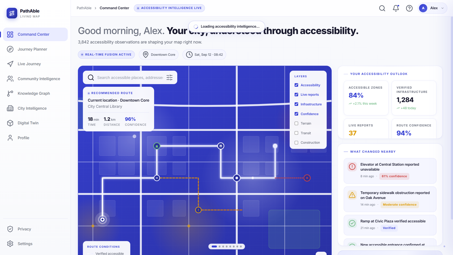
- PathAble creates an accessibility-aware navigation layer over existing urban maps. Instead of treating accessibility as an optional filter, the system incorporates it directly into route computation.
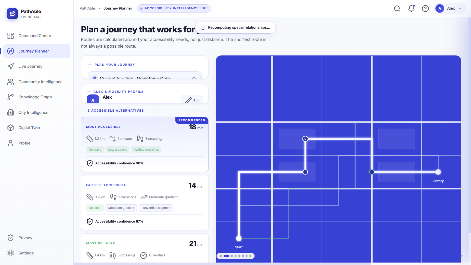
- Each user can create an Accessibility Profile containing relevant preferences such as wheelchair type, maximum acceptable gradient, minimum pathway width, tolerance for uneven surfaces, elevator dependence, preferred crossing types, and other mobility requirements.
- The platform maintains an Accessibility Knowledge Graph representing relationships between users, roads, sidewalks, buildings, entrances, ramps, elevators, crossings, obstacles, accessibility facilities, and reported conditions.
- Accessibility information is modelled as spatiotemporal data, allowing PathAble to understand both where a condition exists and when it is likely to be valid. A functioning elevator and a broken elevator should not produce the same route simply because both are located in the same building.
- PathAble uses multi-source data fusion to combine structured map information, municipal datasets, terrain and slope information, infrastructure data, building information, and community observations.
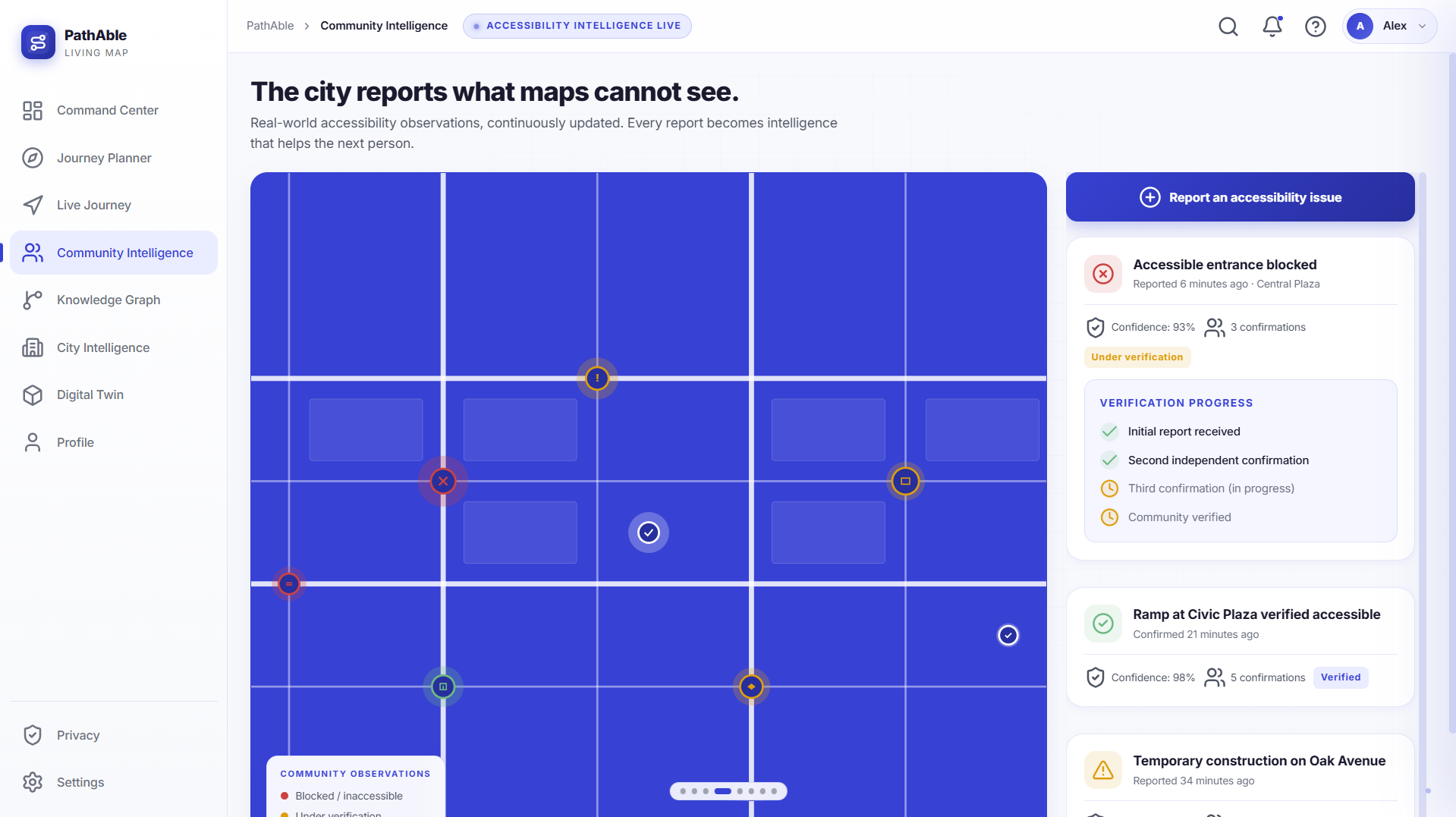
- A confidence-scoring model evaluates how trustworthy each accessibility observation is using factors such as source reliability, recency, frequency of reports, and agreement between independent observations.
- The routing engine uses multi-objective route optimization, balancing accessibility, safety, distance, gradient, surface condition, number of crossings, elevator dependency, reliability, and estimated travel time according to the user's individual requirements.
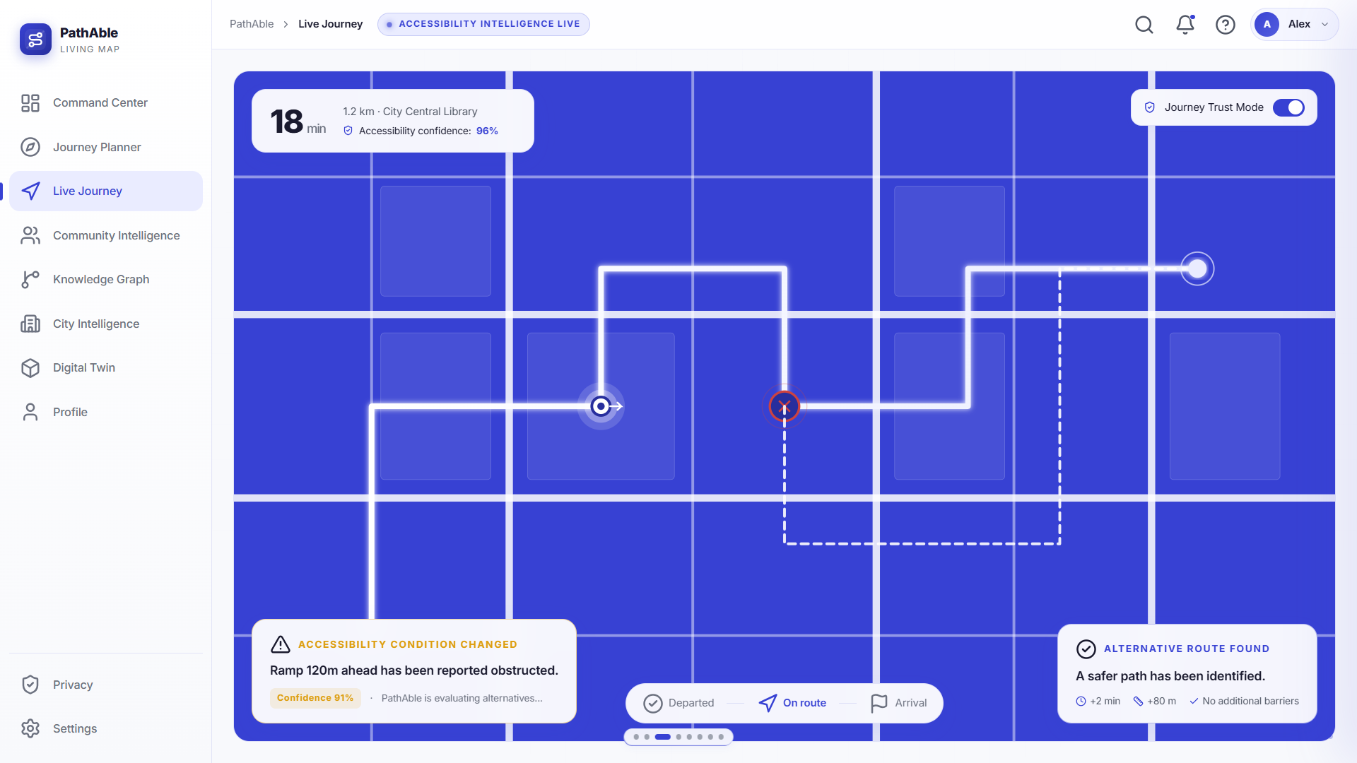
- The platform continuously performs anomaly detection to identify contradictions and rapidly changing conditions. If a location is officially marked accessible but multiple recent users report a blocked entrance, PathAble can detect the discrepancy and lower its confidence until the situation is verified.
- Users can submit structured real-world observations such as “ramp blocked,” “elevator unavailable,” “sidewalk damaged,” “accessible entrance changed,” or “construction obstructing pathway.” Reports can include timestamps and supporting evidence, allowing the accessibility map to evolve with the physical environment.
- PathAble follows a human-in-the-loop architecture. AI can detect patterns, estimate conditions, prioritize uncertain reports, and identify potential accessibility failures, while users and authorized organizations remain involved in verification.
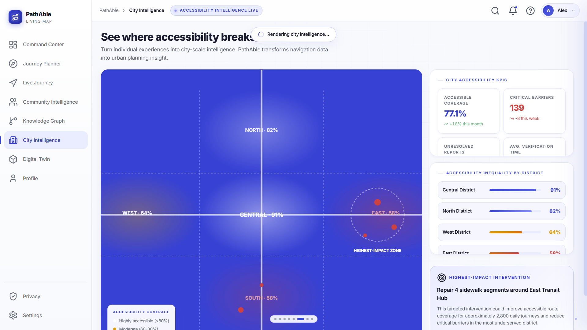
- For governments, universities, hospitals, transport authorities, and property managers, the platform provides an Accessibility Intelligence Dashboard that identifies recurring barriers, inaccessible zones, infrastructure failures, and locations where accessibility improvements could have the greatest effect.
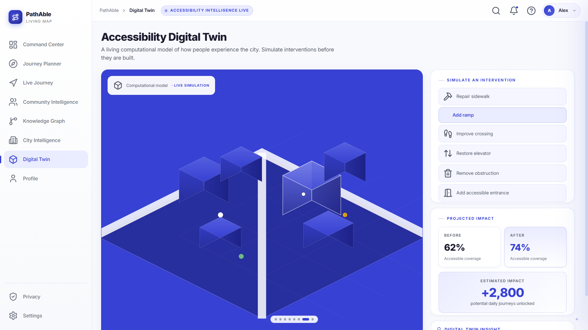
- An Accessibility Digital Twin can provide a computational representation of accessibility across an area, allowing institutions to understand how changes such as repairing a pavement, installing a ramp, modifying a crossing, or restoring an elevator could improve accessibility.
- The entire system follows privacy-by-design principles, minimizing unnecessary collection of personal information while still providing meaningful personalization and community intelligence.
- At the service-design level, PathAble establishes a structured civic feedback loop: citizens can report lived accessibility problems, communities can validate observations, responsible institutions can receive prioritized information, and resolved interventions can be reflected back into the shared accessibility system.
- The platform can therefore be adopted as a civic accessibility service even before sophisticated technology is available everywhere. A city, university, hospital, or transport authority could begin with accessibility audits, community reporting, verification procedures, and institutional response workflows, while progressively introducing the more advanced AI and geospatial capabilities.
- This makes the proposal intentionally broader than a software implementation. The technology provides the intelligence layer, while the underlying innovation is the creation of a repeatable framework for how accessibility problems are discovered, communicated, prioritized, resolved, and monitored over time.
5. Innovation & Uniqueness
- Dynamic accessibility: PathAble recognizes that accessibility changes with construction, maintenance, temporary obstructions, infrastructure failures, and other real-world conditions. Accessibility therefore becomes continuously updated information rather than a permanent database label.
- Deep personalization: The platform does not assume that every wheelchair user has identical requirements. Route suitability is calculated against the individual's actual accessibility profile.
- Confidence-aware navigation: Rather than presenting uncertain information with false certainty, PathAble can incorporate the reliability of accessibility data into route selection and communicate uncertainty to the user.
- Community intelligence: People who experience accessibility barriers firsthand can contribute observations that improve the shared accessibility knowledge base for future users.
- AI-assisted verification: Machine learning and anomaly detection help identify suspicious, outdated, or conflicting information while human verification provides an additional layer of trust.
- Accessibility Digital Twin: The system extends beyond navigation by creating a computational view of urban accessibility that can help institutions identify patterns and prioritize interventions.
- Individual and institutional impact: The same underlying data can help an individual make a safer journey today while helping an institution identify and fix the infrastructure problem that caused the difficulty in the first place.
- The fundamental innovation is a change in perspective: PathAble does not simply map where roads and buildings exist. It attempts to map whether those spaces are genuinely usable by the people who depend on accessible infrastructure.
- Its innovation is therefore not dependent on the existence of a particular algorithm or technology. The core innovation is the service model that turns fragmented individual experiences into trusted community knowledge and then into actionable institutional and urban intelligence.
- PathAble also introduces a potential governance framework for accessibility. Rather than treating accessibility as something assessed only during construction or inspection, cities and organizations can continuously monitor how infrastructure performs in actual use and prioritize interventions according to evidence and community need.
6. Supporting Materials
Absolutely. Based on the PathAble concept, I’d structure these as presentation-ready content rather than overly technical business analysis. The key is to show that PathAble is not just a navigation app—it can become a sustainable accessibility service and civic intelligence platform.
a. Sustainability Assessment
Environmental Sustainability
- Promotes efficient mobility: Personalized accessible routes can reduce unnecessary detours and failed journeys.
- Supports better infrastructure planning: Accessibility data can help cities prioritize repairs and upgrades instead of making infrastructure investments blindly.
- Encourages sustainable transport: By making accessible walking routes and public-transport connections more reliable, PathAble can make low-carbon mobility more usable for people with disabilities.
- Digital-first model: The platform relies primarily on digital data, community reporting, and existing geospatial infrastructure rather than requiring new physical infrastructure to operate.
Social Sustainability
- Improves independent mobility for wheelchair users and people with mobility limitations.
- Reduces travel uncertainty and dependence on caregivers or strangers.
- Creates community participation: Users contribute real-world accessibility information that benefits others.
- Promotes inclusive cities: Institutions receive evidence about accessibility problems that may otherwise remain invisible.
- Supports equitable access to education, healthcare, employment, public transport, and social activities.
Economic Sustainability
- Helps institutions prioritize high-impact accessibility investments using real-world evidence.
- Reduces duplicated accessibility audits by maintaining a continuously updated information layer.
- Creates opportunities for institutional subscriptions, accessibility analytics, partnerships, and enterprise services.
- Can begin as a focused pilot and scale geographically rather than requiring city-wide infrastructure investment from day one.
Overall Sustainability
PathAble creates a feedback loop:
Citizen experience → Community verification → Accessibility intelligence → Institutional action → Improved infrastructure → Better citizen experience
This makes accessibility improvement continuous rather than a one-time assessment.
b. Financial Model
Revenue Streams
| Revenue Source | How it Works |
|---|---|
| Institutional SaaS | Universities, hospitals, transport authorities, property managers, and municipalities pay for accessibility dashboards and analytics. |
| Municipal / Government Contracts | Cities purchase accessibility mapping, monitoring, and urban-planning intelligence. |
| Enterprise Accessibility Audits | Organizations pay for accessibility assessments and continuous monitoring of their properties. |
| API / Data Services | Organizations can access PathAble's accessibility intelligence through APIs. |
| Premium Analytics | Advanced forecasting, hotspot detection, digital-twin analysis, and infrastructure prioritization. |
| Partnerships & Grants | Disability organizations, NGOs, research programs, and social-impact initiatives can fund pilots and expansion. |
Cost Structure
Major costs:
- Software development and maintenance
- Cloud infrastructure and geospatial data
- Machine learning and data processing
- Accessibility research and user testing
- Community engagement and verification
- Sales, partnerships, and institutional onboarding
- Compliance, privacy, and security
Financial Strategy
Phase 1 — Pilot
Grants + university/NGO partnerships + limited institutional contracts
Phase 2 — Regional Expansion
Institutional SaaS + accessibility audits + government contracts
Phase 3 — Scale
SaaS + API/data services + enterprise analytics + large municipal contracts
Key Financial Principle
Keep the core accessibility service accessible to users while monetizing institutional intelligence.
This avoids making essential accessibility information dependent on a user's ability to pay.
c. Market Research
Target Market
Primary Users
- Wheelchair users
- People with mobility impairments
- Caregivers
- Accessibility organizations
Institutional Customers
- Municipal governments
- Universities and campuses
- Hospitals
- Public transport authorities
- Property managers
- Smart-city organizations
- Urban planners
Market Gap
Current navigation platforms primarily optimize for:
Distance + Time + Traffic
PathAble adds:
Accessibility + Personal Requirements + Reliability + Real-Time Conditions
The opportunity lies in the gap between "a place is mapped" and "a person can actually reach and use it."
Competitive Landscape
| Existing Approach | Limitation | PathAble Difference |
|---|---|---|
| Conventional navigation | Optimizes general travel efficiency | Accessibility is part of route computation |
| Accessibility directories | Often location/facility focused | Evaluates the complete journey |
| Static accessibility audits | Become outdated | Continuous community updates |
| Crowdsourced maps | Useful but often unstructured | Structured observations + confidence scoring |
| Municipal accessibility data | Institution-focused | Combines institutional + lived experience |
| Generic accessibility filters | "Accessible/not accessible" | Personalized to individual requirements |
Market Entry Strategy
Rather than trying to map an entire city immediately:
Start with high-value environments → University campus / hospital district / transport hub
Build verified accessibility data → Community reporting + institutional data
Demonstrate measurable impact → Better routes + identified barriers
Expand geographically → City → Region → Multiple cities
d. Business Model
B2B2C + Civic Partnership Model
The user receives the accessibility benefit, while institutions become the primary paying customers.
Value Proposition
For Users
"Know whether your journey is actually possible before you start."
For Institutions
"Know where accessibility is failing, why it is failing, and where intervention will have the greatest impact."
Business Model Canvas
| Component | PathAble |
|---|---|
| Customer Segments | Wheelchair users, universities, hospitals, municipalities, transport authorities, property managers |
| Value Proposition | Personalized accessible navigation + continuously updated accessibility intelligence |
| Channels | Mobile/web platform, institutional partnerships, accessibility organizations |
| Customer Relationships | Community participation + institutional support + continuous reporting |
| Revenue | SaaS, government contracts, audits, API/data services, analytics |
| Key Resources | Accessibility data, knowledge graph, routing engine, community network, ML models |
| Key Activities | Mapping, verification, routing, analytics, reporting, institutional support |
| Key Partners | Municipalities, disability organizations, universities, hospitals, transport authorities |
| Cost Structure | Technology, cloud, data, research, community engagement, partnerships |
Why This Model Works
The most valuable PathAble data is shared infrastructure:
A single accessibility observation can simultaneously:
- help a wheelchair user avoid a barrier,
- improve route calculations,
- identify an infrastructure problem,
- inform an institution,
- and contribute to long-term urban planning.
One data point → multiple forms of value.
7. Project Presentation
- Target users: Wheelchair users, people with mobility impairments, caregivers, accessibility organizations, hospitals, universities, transportation authorities, property managers, and urban planning bodies.
- Implementation approach: The concept can begin with a focused geographic pilot, establish the accessibility data model, introduce personalized routing and community reporting, and progressively add predictive analytics, anomaly detection, and institutional intelligence.
- Required resources: Geospatial and accessibility datasets, mapping infrastructure, machine learning capabilities, accessibility expertise, user research, software infrastructure, and partnerships with municipalities or accessibility organizations.
- Major challenges and responses:
| Challenge | Proposed Response |
|---|---|
| Accessibility information becomes outdated | Use timestamps, confidence scores, repeated observations, and anomaly detection to identify changing conditions. |
| Users have different accessibility requirements | Generate routes according to individual accessibility profiles rather than using one universal accessibility score. |
| Community reports may conflict | Compare recency, source reliability, multiple observations, and verification status. |
| Initial accessibility data may be limited | Begin with high-value locations and progressively expand coverage through partnerships and community participation. |
| Privacy may become a concern | Apply privacy-by-design principles and minimize unnecessary personal data collection. |
| Urban environments change frequently | Treat accessibility as spatiotemporal information that can be continuously updated. |
- Expected outcomes: PathAble aims to reduce uncertainty before and during travel, improve independent mobility, make accessible routes more reliable, and provide institutions with actionable evidence about accessibility barriers.
- Evaluation metrics: The concept can be evaluated through route accessibility accuracy, barrier detection accuracy, report verification rate, routing reliability, user satisfaction, reduction in inaccessible-route recommendations, and the number of accessibility issues identified and resolved.
- Demonstration concept: A prototype can demonstrate the same destination being evaluated for different wheelchair profiles, followed by a simulated event such as a blocked ramp or unavailable elevator. The system can then recalculate the route and explain why the new route is preferable.
- Long-term vision: PathAble can evolve from an accessibility navigation platform into a broader urban accessibility intelligence layer, where real-world observations from citizens continuously improve navigation while aggregated insights help institutions build more inclusive environments.
- Civic and policy vision: Over time, PathAble can support a model where accessibility is treated as a continuously measurable public-service outcome. Municipalities and organizations can use real-world accessibility evidence to identify underserved areas, prioritize infrastructure spending, monitor the effectiveness of interventions, and make future planning decisions around the experiences of the people who actually use those spaces.
- Final project statement: PathAble is built around a simple principle: accessibility should not be something a person discovers only after reaching a barrier. It should be something they can understand and trust before beginning the journey. By combining human experience with geospatial computing, AI, community intelligence, and urban analytics, PathAble aims to make independent movement more predictable, more informed, and more possible.

Log in or sign up for Devpost to join the conversation.