-
-
SharkHack Development Model

Inspiration
Throughout the United States, "motorists spend an average of 17 hours a year searching for spots on streets, in lots, or in garages", this is a growing and contentious issue. Personally speaking, this issue heavily involves our own experiences as urban dwellers and drivers who run into similar issues as we primarily drive to our colleges, workplaces, and homes. In addition, our inspiration is driven by a passion for data analytics and machine learning which plays an integral role in the development of our proposed program and idea.
What it does
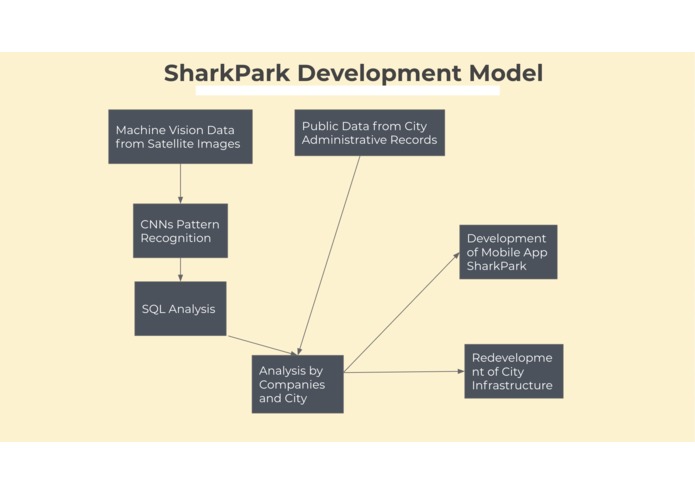
In essence, our approach is to propose the creation of a well-functioning program in which the Geographic Information System (GIS) framework and spatial sciences integrate imagery and converts it to specific datasets, next using coevolution neural networks (CNNs) to run through satellite images of urban space, generating a pattern recognition of parking lots, cars, and parking garages in an urban setting. Furthermore, these datasets are turned to SQL queries that can store and analyze data to proactively be able to conduct a multitude of analysis programs. The resulting analytics produced from the practical output can be easily read and understood by city developers, companies, and governments in order to take further actions needed to solve problems faced by residents and their vehicles. In addition, the data can be developed into a program that can help individuals find the most optimal parking spaces throughout urban areas.
How we built it
Due to the complex and multifaceted nature of our issue and the topic prompt— "How might we use publicly available data to solve problems faced by city dwellers and their vehicles?", it was difficult to build a program that was able to integrate machine vision technology which we lacked access to, in addition, we were recommended to focus on highlighting our idea and the rationale behind our thought process.
Challenges we ran into
In the endurance of our project ran into a multitude of challenges including the difficulties associated with producing code based implementations of our idea and understanding machine vision. Although producing an apt code for this issue was a challenge, we were able to successfully supplement our idea with a written response and mockup of our app-based code. Similarly, the issues we faced regarding understanding machine vision were resolved as we conducted an immense amount of research in order to truly comprehend the topic and understand its importance to our proposed idea.
Accomplishments that we're proud of
Certain accomplishments that we're proud of include our extensive paper regarding our rationale, thought-process, and final outcome; in addition, we're immensely proud of the mockup we've produced of the possible mobile app development. Through these two accomplishments, we've been able to orient ourselves towards a finalized idea of our program, in addition, to understand the topic of machine vision.
What we learned
In overall, our team was able to learn and understand the wide-ranging impact of parking issues throughout urban spaces, in addition to learning the methodology and processes behind the collection of data via machine vision, the ideas behind the execution of coevolution neural networks, and integration of SQL queries. In addition, we understood and gained insight into the impact that our project and idea could have on individuals and organizations.
What's next for ParkHub Challenge: SharkPark
The future for SharkPark includes the implementation of the vast machine vision program that is developed can inevitably assist cars and city residents as the statistics and trends produced can be embedded and utilized in a mobile app or a layer in Google Maps that can identify certain parking lots and assist a user in finding a parking space. Through machine vision, one is able to not only solve a contentious issue regarding city dwellers and their vehicles but create a potential product for individual businesses to seek profit from.
Built With
- gis
- location-labs-spatial-storage
- machine-vision
- sql
- swift
- xcode


Log in or sign up for Devpost to join the conversation.