Inspiration
India’s agriculture is dominated by smallholder farms that struggle with fragmented land, irregular yields, and limited access to reliable data driven tools. Existing crop classification systems are designed for large, homogeneous farms and fail at parcel-level precision. This gap inspired us to build a system tailored for India’s small farms that combines multi-modal satellite data, explainable AI, and local ground truth to provide actionable insights.
What it does
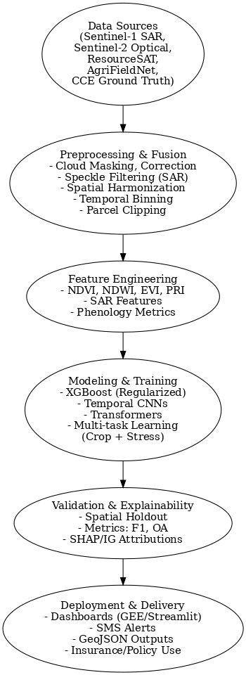
Our system delivers parcel level crop classification and monitoring by fusing Sentinel-1 SAR, Sentinel-2 optical time series, and ResourceSAT datasets. It classifies crops, detects early stress (water, canopy, photosynthesis issues), and provides explainable outputs with feature attribution. The system generates high-resolution crop maps, early warnings via SMS, and dashboards for stakeholders, making insights actionable and transparent.
How we built it
Data fusion: Integrated Sentinel-1, Sentinel-2, and ResourceSAT with the AgriFieldNet dataset. Ground truth: Enriched with geotagged Crop Cutting Experiment (CCE) data. Feature extraction: Computed NDVI, NDWI, EVI, PRI indices + phenological growth curves. Modeling: Used temporal CNNs + Transformers with a multi-task learning framework for classification + stress detection. Optimization: Applied XGBoost with cross-validation and error correction to minimize overfitting. Explainability: Gradient-based attribution + vegetation density analysis for interpretable outputs.
Challenges we ran into
Aligning fragmented field boundaries with satellite pixels. Handling cloud cover and seasonal variations in optical data. Preventing overfitting due to limited high-quality ground truth. Making the system explainable and trustworthy for policymakers and farmers.
Accomplishments that we're proud of
Gained a deeper understanding of India’s agricultural geography and heterogeneity, particularly the classification challenges in fragmented farms of Uttar Pradesh, Bihar, Rajasthan, and Odisha. Learned how to effectively fuse Sentinel-1 SAR (backscatter for structure/soil moisture), Sentinel-2 multispectral (optical signatures), and ResourceSAT LISS data (higher spatial resolution) for robust crop identification under varying monsoon/cloud conditions. Explored time-series crop phenology curves, realizing that modeling spectral/radar changes across growth stages gives higher precision than static classification. Strengthened skills in geospatial data handling, including atmospheric correction, speckle filtering in SAR, feature extraction (NDVI, NDWI, EVI), and aligning field parcels with pixel-level data. Gained hands-on experience in AI/ML for geospatial tasks, such as fine-tuning geospatial foundation models (TerraTorch), implementing XGBoost with regularization to reduce overfitting, and experimenting with attention-based temporal models for multi-season classification.ta Built confidence in combining AI pipelines with agricultural domain knowledge, moving towards decision-support systems that can serve farmers, insurance agencies, and policymakers at scale.
What we learned
Parcel-level precision is crucial in India’s context. Temporal modeling (phenological growth signatures) significantly improves classification accuracy. Explainability builds trust and adoption more than accuracy alone. Multi-modal fusion (SAR + optical) is essential for overcoming cloud and monsoon conditions.
What's next for Parcel-Level Crop Intelligence for Smallholders
Pilot deployment in selected districts with state agriculture departments. Integration with Google Earth Engine for scalability. Develop a farmer-facing mobile app for alerts and insights. Explore quantum ML and foundation model fine-tuning for improved performance. Collaborate with policy makers and insurance companies to use outputs in decision-making and claim verification.
Built With
- bhuvanapi
- earthengine
- evi
- ibm-watson
- ndvi
- postgis
- python
- pytroch
- sckitlearn
- sentinel-monitoring
- sql
- terratorch

Log in or sign up for Devpost to join the conversation.