-
-
Framework
-
OpenWildfire
Inspiration
As residents of California, the shadow of wildfire season looms large over us every year. We've seen the devastation it can cause to communities and the immense pressure it puts on first responders. This project was born from a deep desire to support these heroes on the front lines. We identified a critical gap: while data is abundant, existing systems often struggle with real-time analysis and fail to provide clear, actionable guidance during the crucial, initial moments of a potential disaster. We saw the potential of OpenAI's gpt-oss-20b as the perfect tool to bridge this gap. Its powerful reasoning capabilities, combined with its efficiency and local deployability, inspired us to build a system that could turn complex data into decisive action.
What it does
OpenWildfire is an AI-powered wildfire risk assessment system that acts as an intelligent co-pilot for emergency response teams. It ingests a wide array of real-time data:
Multi-Camera Analysis: It clusters and analyzes live camera feeds to detect the earliest signs of fire or smoke.
Real-time Weather Integration: It pulls current data on humidity, wind speed, and temperature from weather APIs for immediate environmental context.
Geographic Risk Assessment: It leverages California's official Fire Hazard Severity Zone (FHSZ) maps and historical fire data to understand the long-term risk profile of an area.
The system then uses its AI core to evaluate this fused data, assigning a clear risk level from 1 (Low) to 5 (Extreme). It doesn't stop there; it automatically generates a detailed Fire Risk Assessment Report, complete with actionable emergency recommendations. These recommendations are enhanced with a Retrieval-Augmented Generation (RAG) system to ensure they are context-aware and grounded in authoritative documents from CAL FIRE, NIST, and other official sources.
How we built it
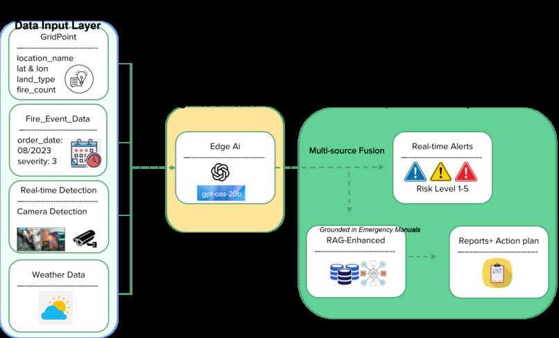
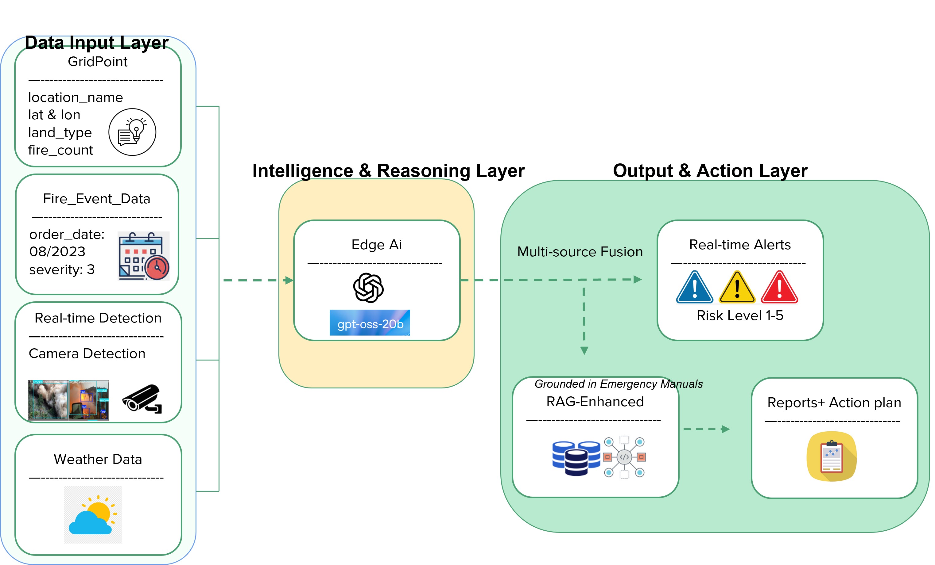
Our system is built on a modular, three-layer architecture designed for clarity and scalability.
Data Input Layer: This is where we gather our intelligence. Custom scripts process camera monitoring data (camera_monitoring_dataset.jsonl), geographic information (nested_california_fire_risk_enhanced_dataset.jsonl), and call the OpenWeatherMap API for live weather data.
Intelligence & Reasoning Layer: The heart of the system is OpenAI's gpt-oss-20b. We configured it to act as an "Edge AI" agent. It takes the fused data from the input layer and performs a complex analysis, weighing all the variables—from wind speed to historical fire frequency—to determine the risk level. The model runs locally, ensuring speed and data privacy.
Output & Action Layer: Once the AI has made its assessment, this layer creates the output. A report_generator.py script formats the analysis into a structured JSON file. Crucially, our emergency_rag.py script, built with LangChain and a ChromaDB vector database, enriches this report. We populated the database with official emergency procedure PDFs, allowing the system to pull the most relevant, expert-vetted recommendations for the specific situation. Finally, an HTML generator visualizes the report for easy interpretation.
Challenges we ran into
Fusing disparate data sources into a single, coherent prompt for the AI was a significant challenge. At first, the model struggled to correctly weigh the importance of a new fire detection versus, for example, high humidity. It required careful prompt engineering to create a logical framework for the AI to follow.
Another major hurdle was ensuring the AI's recommendations were not just plausible but were genuinely safe and actionable. Generic advice is useless in a crisis. This led us to implement the RAG system. Building the vector database and integrating it with LangChain to ground the model's output in official emergency manuals was a critical step to ensure the system provides reliable, expert-level guidance.
Accomplishments that we're proud of
We are incredibly proud to have built a complete, end-to-end system that goes from raw, multi-modal data to a finished, actionable intelligence report. Seeing our system correctly process the Shasta County data, identify the fire, and immediately recommend the closest fire station was a moment of huge validation for our approach.
Successfully deploying the powerful gpt-oss-20b model in a local, edge-computing context is another major accomplishment. It proves that open-source models can be used to build sophisticated, mission-critical applications without relying on massive cloud infrastructure.
What we learned
This project drove home the lesson that in critical AI systems, reasoning must be grounded in reality. An LLM's ability to generate text is powerful, but its true value is unlocked when its outputs are tethered to a body of expert knowledge, which we achieved using RAG. We also learned the immense power of data fusion; the AI's insights were far more valuable when it could see the whole picture—visual, environmental, and historical data—at once. Finally, this hackathon has shown us that the open-source AI community has produced tools that are more than capable of tackling serious, real-world problems.
What's next for OpenWildfire
We see this project as the foundation for a more comprehensive wildfire management platform. Our next steps are:
Implementing Predictive Capabilities: Integrating models to forecast potential fire spread based on terrain and weather, moving from reactive assessment to proactive prediction.
Expanding Data Integrations: Adding new data sources, such as satellite imagery and 911 call data, to create an even more complete operational picture.
Seeking Real-World Feedback: Partnering with local fire departments to pilot the system and refine it based on the needs of actual first responders.
Built With
- fhsz
- gpt-oss-20b
- python
- rag


Log in or sign up for Devpost to join the conversation.