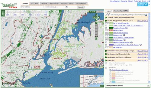
The Open Accessible Space Information System (OASIS) mapping website helps sustain New York City’s open spaces and visualize the nexus between community greening and broader urban planning issues. It is a richly layered mashup of data from the city, state, and federal government and environmental and community organizations. Organizations and individuals – including city agencies – use it regularly to map their neighborhood, understand local and regional land use patterns, and view a wealth of information not integrated anywhere else in one place freely accessible online.
OASIS is the result of the USDA Forest Service’s vision in late 2000 and has been substantially enhanced since then. The project is guided by a collaborative partnership of almost 60 greening groups, educators, individuals, businesses, nonprofits, and public agencies who use online mapping technology to help sustain the city’s open spaces and visualize the nexus between community greening and broader urban planning issues. The website integrates the DataMine datasets with many other layers of mapped information including historic and contemporary aerial imagery.
Features include dynamic transparencies for any layer on the map, historic aerial timeline slider (fade between imagery from 1996 to 2006), Microsoft Bing bird's eye view images for any spot on the map, local environmental stewardship turfs in partnership with the USDA Forest Service, photorealistic imagery of Manhattan circa 1609 in partnership with the Wildlife Conservation Society’s Mannahatta project, Yahoo! local search results for each property in the city, and more.

Log in or sign up for Devpost to join the conversation.