-
-
App Screenshots
Nomad
Track
Health & Wellness
Inspiration
As CS majors, we sit a lot. Doing homework, sitting. Entertainment, sitting. Commuting to campus, sitting in car. In class, sitting. Eating, sitting. Our campus is small, so there isn't much built-in walking. This is bad for our health and makes it surprisingly hard to reach 10,000 steps a day.
Reaching 10,000 daily steps is a widely recommended target to increase physical activity. It's associated with reduced risk of cardiovascular disease, type 2 diabetes, and certain cancers, while supporting weight management, lowering blood pressure, improving mental health, and increasing longevity.
What it does
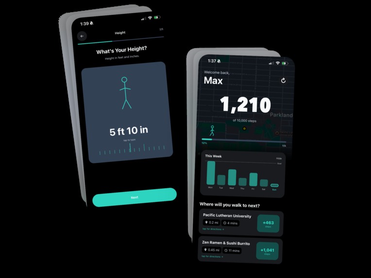
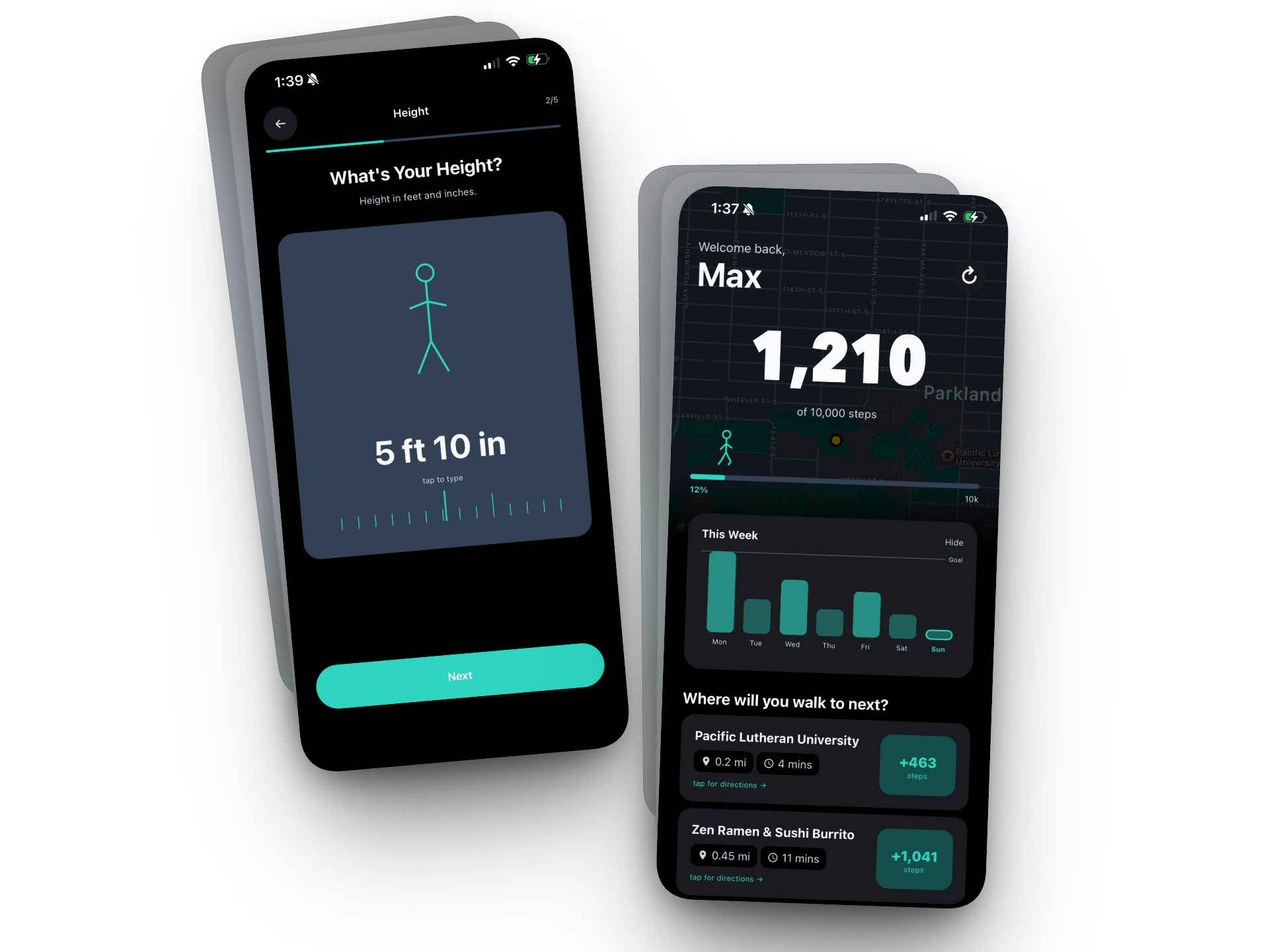
Nomad is a mobile app that turns your daily steps into a mission. It reads your phone's pedometer to track steps in real time, then uses your location and height to recommend nearby places — landmarks, campus buildings, parks, cafes — showing exactly how many steps you'd earn by walking there, how far it is, and how long it'll take.
Key features:
- Live step counter with a progress bar and walking stick figure that moves as you get closer to your goal
- Faded map background centered on your location (NRC-inspired)
- Collapsible weekly activity chart pulled from Apple HealthKit
- Nearby place cards showing distance, walking time, and steps gained — tap to open walking directions in Apple Maps or Google Maps
- Custom onboarding that collects your name, height (for stride calculation), and step goal, then walks you through Health and Location permissions before any system dialogs appear
- Automatic dark mode that follows your device theme, including the map
How steps are calculated
We estimate steps to a destination using the user's height:
stride_length = 0.415 × height_in_inches
steps = (distance_miles × 5280 × 12) / stride_length
How we built it
Frontend:
- React Native with TypeScript, Expo managed workflow
- Expo Router for file-based navigation
expo-sensors(Pedometer) for HealthKit step dataexpo-locationfor user positioningreact-native-mapsfor the background map
Backend:
- Flask (Python) server
- Google Places API (Nearby Search) to find landmarks, campus buildings, parks, gyms, restaurants, and more
- Google Distance Matrix API to get walking distances and durations
- Minimum distance filter (0.15 mi) so you don't get results for the building you're already in
- Results sorted by distance, capped at 20
AI Tools:
- Claude Opus 4.6 (claude.ai)
- Cursor
Storage:
- No database, user preferences (name, height, goal) stored on-device with AsyncStorage
What's next for Nomad
- Multi-stop routes: "Walk to the park, then the library, then back home" to hit your goal with a loop
- Longer path options: the Distance Matrix API returns the shortest path, but sometimes a longer scenic route earns more steps
- Apple Health sync: import name and height from HealthKit so users who grow (or update their profile) stay in sync automatically
- User-defined places: let users pin their own favorite destinations
- Gamification: streaks, badges, celebrations when you hit your goal, weekly challenges
Built With
- React Native
- TypeScript
- Expo
- Flask
- Python
- Google Places API
- Google Distance Matrix API
- Claude AI
Demo
[Video link here]
Built With
- expo.io
- flask
- google-maps-platform
- python
- react-native
- typescript


Log in or sign up for Devpost to join the conversation.