Inspiration
Underground mine rescue is a high-risk environment where GPS does not work, communication can be weak, and rescue teams may not know what changed after an incident. Existing underground drones can help with mapping, but raw video, point clouds, or sensor data are not enough during an emergency.
Noctavus was inspired by one core question:
How can we turn underground robotic data into clear rescue decisions?
What it does
Noctavus is a MineRescue Mobile Edge Mothership system. It combines a small autonomous drone with a mobile ground vehicle/mothership.
The drone is designed to stay lightweight. It enters dangerous mine tunnels, scans the environment, detects possible hazards, and returns to the mothership. Instead of forcing the drone to carry a heavy computer, the mothership carries the larger battery, edge-compute system, communication relay, docking station, and rescue dashboard.
The goal is not just to map the mine. The goal is to help rescue command answer important questions:
- What changed after the incident?
- Which tunnel is blocked?
- Which route may still be usable?
- Where are heat, smoke, gas, or visibility risks?
- Where might workers or refuge chambers be?
- Which information is reliable, and which information is uncertain?
- What should rescuers verify next?
How we built it
We built Noctavus as a rescue-intelligence prototype with a dashboard-centered workflow.
The system is organized around two parts:
1. Autonomous scout drone concept
The drone represents the fast scouting layer. It is responsible for entering GPS-denied mine areas, collecting visual and sensor information, avoiding obstacles, and returning when battery, signal, or safety conditions become risky.
2. Mobile edge-compute mothership
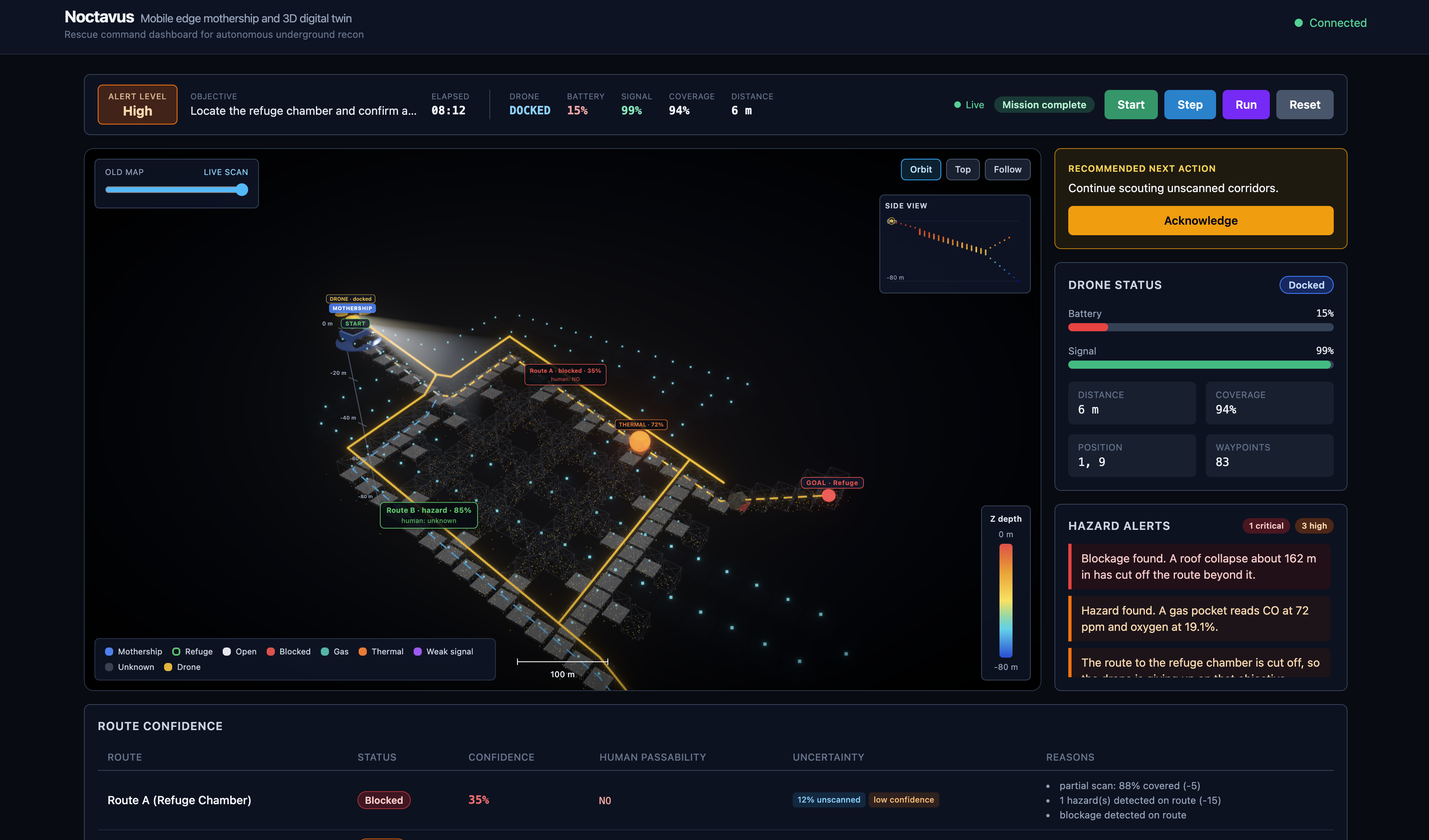
The mothership represents the decision-making layer. It receives the drone data, processes it with AI/VLM support, builds a live rescue map, highlights hazards, compares the current scan with prior mine information, and presents the result through a command dashboard.
The dashboard focuses on simple rescue communication: blocked paths, danger zones, route confidence, sensor warnings, and next-step guidance.
Challenges we faced
One major challenge was avoiding the mistake of making the drone too heavy and complex. A rescue drone needs to be small, fast, and reliable. That led us to separate the system into two parts: a lightweight drone and a stronger mothership that handles the heavy computation.
Another challenge was designing the project around real rescue usefulness, not just technology. In an emergency, rescue teams do not only need data. They need clear decisions, uncertainty awareness, and fast situational understanding.
What we learned
We learned that the most important part of mine rescue robotics is not only autonomy or mapping. The real value comes from turning messy underground data into something rescue command can act on.
We also learned that edge computing can make the system more practical. The drone can stay lightweight while the mothership handles AI processing, visualization, storage, and communication.
What makes it different
Many underground robotic systems focus on mapping, inspection, or remote viewing. Noctavus focuses on the next step:
Turning underground drone data into rescue decisions.
Instead of only showing raw scans, the system aims to show what changed, what is dangerous, what route may still be usable, and what rescuers should verify next.
What's next
Next, we want to improve the simulation, add stronger 3D map visualization, connect more sensor streams, and test the workflow with realistic mine-rescue scenarios. The long-term goal is to make Noctavus a practical rescue-intelligence layer for GPS-denied underground emergencies.


Log in or sign up for Devpost to join the conversation.