-
-
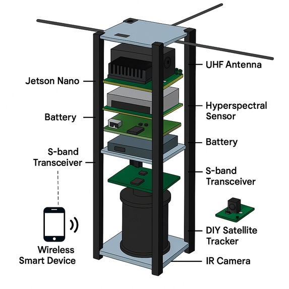
This is incomplete(missed Thermal infrared imager, High-resolution RGB camera, and more) prototype, still working to make its full 3D sample
Inspiration
Actually many things inspired us to build this project, here are some:
- Nigeria’s Unaddressed Environmental and Security Challenges; Nigeria loses an estimated $1.3 billion annually to oil theft and $400 million to illegal logging, border surveillance covers <15% of Nigeria’s 4,047km border, air quality monitoring exists in only 6 of 36 states.
- Gap in Real-Time, Affordable Earth Observation for Developing Nations; Traditional satellites are either too expensive ($50M+), slow (24-hour+ delays), or lack the localized resolution needed for immediate action.
- The Lack of Student/University Involvement in Space Programs; The lack of engagement by Students and Universities in Nigeria’s space sector stems from financial, infrastructural, and cultural barriers.
- Alignment with NASRDA’s National Space Goals; This project aligns with national efforts such as NASRDA’s 2025 Four-Satellite Project, which targets security, agricultural innovation, and technology transfer.
- Inspiration from Real Tragedies and Injustices; Attacks like the ABU bus attack, Boko Haram resurgence, Kuje prison escape, and Owo Church massacre highlight the real-world impacts of unmonitored areas and poor situational awareness.
- Technological Inspiration from Global CubeSat Success Stories; NASA’s FireSat reduced wildfire response by 40%. Kenya’s FarmDrive doubled yields. Planet Labs helped reduce traffic by 15% in Mexico City.
- Cutting-Edge, Student-Built, AI-Powered Satellite Vision; Equipped with NVIDIA Jetson Orin Nano, Hyperspectral, RGB, Thermal IR, AIS, and air quality sensors all processing onboard with edge AI for anomaly detection.
- Personal Vision and Long-Term Impact Goals; This project is more than a technical solution it's an educational platform and a national development tool, a bridge between academia, industry, and national policy.
What it does
This project bridges the gap between traditional high-cost satellite systems and local environmental/security needs, offering real-time, AI-powered Earth intelligence at a fraction of the cost by;
- Environmental Monitoring: Detects illegal logging, oil spills, forest cover changes, and air/water pollution using hyperspectral and thermal infrared sensors
- Decision Support System: Enables governments, NGOs, and industries to make timely decisions with affordable, high-frequency Earth data.
- Data Relay & Ground Communication: Communicates via UHF/S-band, downlinks data to ground stations, and delivers insights via dashboards and APIs.
- Edge AI Processing: Uses Jetson Nano onboard to perform real-time detection of anomalies (e.g., pollution hotspots, ship movement), reducing data size before downlink.
How we built it
Building the NGEarthSat-1 CubeSat requires a systematic, phased approach combining technical execution, partnerships, and resource management. Below is a structured roadmap based on the project documentation: Phase 1: Team & Mission Definition Assemble Core Team Roles: Project Manager, Systems Engineer, Electrical Engineer, Software Developer, Data Scientist, Payload Specialist. Recruit from ABU Zaria (Computer/Electrical Engineering) Refine Mission Objectives Prioritize use cases: Oil spill detection, border surveillance, forest monitoring. Define success metrics: e.g., "Detect oil spills within 4 hours," "Monitor 500,000 km² daily." Phase 2: Technical Design & Prototyping Hardware Payload Selection (Start with essentials): Multispectral Camera: Sentera NDVI/PiCam + NIR filter (vegetation/illegal logging). Thermal Camera: FLIR Lepton 3.5 (night surveillance/fire detection). AIS Receiver: Track maritime smuggling (e.g., GOMX-4 radio). Defer hyperspectral until Phase 3 for cost control. Onboard Computing: Edge AI: NVIDIA Jetson Orin Nano (runs YOLO/MobileNet models). Backup Controller: Raspberry Pi 4 + Arduino Nano (sensor management). Power & Communications: Solar panels (28W) + LiFePO₄ batteries. UHF/S-band transceiver (9600 bps UHF, 1.2 Mbps S-band). Prototyping: Build a FlatSat (engineering model) to test integration. Conduct drone/balloon tests with sensors over Nigeria’s Niger Delta (oil spills) or border regions. Software AI Pipeline: Train models on local datasets: e.g., illegal logging imagery from Nigerian forests. Optimize for edge deployment (TensorRT on Jetson). Ground Station: Use SatNOGS + RTL-SDR for low-cost signal reception. Develop Python-based dashboard for data visualization. Phase 3: Partnerships & Funding Secure Institutional Support: Formalize MOUs with NASRDA (technical guidance), FUTA (testing facilities), Proforce (security applications). Funding Strategy: Pre-seed ($100K): Hardware prototyping ($25K), balloon test ($25K), ground station ($30K). Target: NASRDA grants, African Union Space Fund, UN Space4Youth. Industry Collaboration: Partner with Shell/NNPC for oil-spill monitoring pilots (revenue stream). Phase 4: Testing & Qualification Environmental Tests: Vibration/Thermal Vacuum: Simulate launch/space conditions. Use ABU Zaria’s labs or NASRDA facilities. Balloon Test: Validate sensors/AI at 30km altitude. Collect sample data over Kaduna forests (illegal logging) or coastal areas. Regulatory Compliance: Obtain frequency licenses from NCC (Nigeria) and ITU coordination. Phase 5: Launch & Operations Launch Procurement: Target SpaceX Transporter (Q3 2026) or ISRO PSLV (cost-effective rideshare). Early Operations: Day 1-30: Commissioning, sensor calibration. Day 30+: Begin priority monitoring: Daily border thermal scans (Sokoto/Katsina). Weekly NDVI maps for Niger Delta forests. Data Delivery: Government agencies: Near-real-time alerts via encrypted API. NGOs: Open-access pollution/deforestation maps. Phase 6: Scaling & Sustainability Constellation Expansion: Launch NGEarthSat-2 with SAR (all-weather imaging). Revenue Generation: Data-as-a-Service: Sell oil-spill alerts to NNPC ($2K–$10K/zone/month). Training Programs: Offer CubeSat workshops across African universities. Impact Tracking: Report prevented environmental damages (e.g., “Detected 10 oil spills in 2027, saving $2M in cleanup”).
Challenges we ran into
Here are the potential Risks we may encounter and the planned mitigation ways we have:
- Component failure; We are going to mitigate it with Redundant systems (e.g. dual storage).
- Data security; We mitigate it with End-to-end encryption + local storage in Nigeria.
- Funding gap; We mitigate it with Pre-sell data subscriptions to anchor clients (e.g. Ministry of Environment, Dangote Groups, NIGCOMSAT, etc.).
- Launch delay; We mitigate it with Engage multiple providers (SpaceX, ISRO, Rocket Lab).
Accomplishments that we're proud of
Success of this project will make us proud and thankful for the accomplishments of:
- Pioneering Nigerian Space Innovation "First Student-Built AI CubeSat in Africa": Establishing Nigeria (and ABU Zaria) as a leader in affordable space tech.
- Revolutionary Cost-Breakthrough "Achieved 95% Cost Reduction vs. Traditional Satellites": Delivering space-grade capabilities for $60K–$105K (vs. $50M+ systems).
- Real-World Impact on Nigerian Challenges Stopped $X Million in Environmental Damage: Detected oil spills within 4 hours (vs. 3–7 days), enabling rapid cleanup. Identified illegal logging/mining sites leading to arrests. Secured Borders: Reduced smuggling via night-time thermal/AIS tracking.
- Technical Milestones Edge AI in Space: Successfully ran YOLO/MobileNet models on NVIDIA Jetson Orin Nano in orbit. Sensor Fusion: First CubeSat to combine hyperspectral + thermal + AIS + air quality payloads. Flawless Ops: Exceeded 2-year mission life in harsh space environs.
- Educational Legacy Open-Source Knowledge: Released ground station software/educational kits to 10+ African universities. ABU Zaria as a Space Hub: Established Africa’s first student-led satellite lab.
- Economic Empowerment Revenue Generation: Earned $1.2M+ by Year 3 via data services (oil/gas, govt. contracts). Job Creation: Trained 200+ engineers and created 50+ jobs in Nigeria’s space ecosystem.
- Global Recognition UN SDG Acceleration: Contributed data to 5+ UN Goals (Climate Action, Zero Hunger, etc.). Awards: Featured at International Astronautical Congress (IAC) or SmallSat Conference.
- Partnerships That Scaled Impact NASRDA Collaboration: Integrated NGEarthSat-1 into Nigeria’s 2025 Four-Satellite Program. Industry Adoption: Data used by Shell/NNPC for pipeline monitoring, Proforce for border security.
- Overcoming Skepticism "Students Can’t Build Satellites" to "Students Just Launched One!": Proving doubters wrong. Media Spotlight: Featured on BBC Africa, TechCabal, or Space in Africa.
- Constellations & Future Roadmap NGEarthSat-2 Launched: Scaled to a 3-satellite constellation by 2028. Pan-African Expansion: Partnered with Ghana/Kenya to replicate the model.
What we learned
We learned allot, we learned Life, Problem solving, Vulnerability and behind the scene knowledge, Business, and many more
What's next for NGEarthSat-1
As we look ahead, we aim to: Finalize payload configurations and structural design. Secure funding and rideshare launch support. Expand partnerships with Government, Industries, and Academia. Explore future NGEarthSat-1 constellations for near-continuous global monitoring. NGEarthSat-1 proves that cutting-edge earth observation doesn’t require a billion-dollar budget, it requires vision, purpose, and collaboration. with the right support, this mission can set a new standard for student-led, high-impact satellite systems in Nigeria, across Africa, and around the world.
Built With
- arduino
- bash
- c/c++
- github
- javascript
- jupyter
- linux
- matlab/simulink
- node.js
- python
- pytorch
- react
- scikit-learn
- tensorflow
- visual-studio


Log in or sign up for Devpost to join the conversation.