Inspiration
Over spring break, I visited Guatemala with my roommate because her parents are currently staying in the city. While I was there, I was fortunate to be able to travel to different places with her so we could sightsee the area. However, I was SHOCKED because what would commonly take a car 15 minutes to get to a destination, would take hours. I spoke to many of the residents and sadly they had no hope for improvement. They explained that because of the city being completely packed, there was nothing that could be done. Roads could not be expanded, a transit system could not be implemented, and that meant that the cars would be stuck in traffic. Additionally, this had more repercussions, walking accessibility to places also became challenging as now with limited space, people were at risk.
After witnessing this and seeing residents beg for a change, I decided to create Neighborhood Hero, an AI program that could take in a location (i.e. a local neighborhood) and analyze which parts of the location are unsafe. Then, the bot would later give recommendations on how to fix it these problematic parts. This would help urban planners and engineers find an efficient and cheap way to solve these kinds of problems without having to redo all of the city.
What it does
There are three main steps to the AI software “Neighborhood Hero”
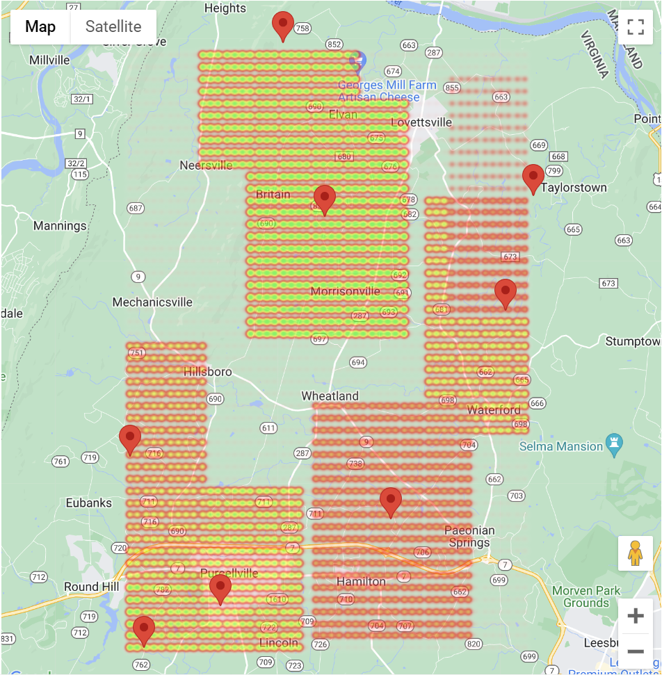
- Neighborhood Hero takes in a location and pulls from Google Maps API and the walk score API to give relative recorded walk scores in the given area
- The program generates an efficacy score based on the location provided and the recorded walk scores in that area
- If the user would like to understand why the score is such, the analyzing / recommendation part of the software will explain why the score was deemed fit. The bot will give recommendations as to what can be implemented and changed in the specific areas that are problematic ## How we built it The website was created with HTML, CSS, and Javascript. The analyzing aspect was created by using GoogleMaps’ API which includes markers (each data point representing a recorded walk score from the Walk Score API) and using these markers to generate a heat map.
Challenges we ran into
The hardest part, which unfortunately I spent too long on, was trying to deploy all of my code on a website. I was so sad that I wasted so much time, but I am hoping I can get it working soon! Additionally, the coordinate calculation for the heat map was very challenging and took up a bulk of the hacking time. Finally, I realize that I wished I worked in a group instead of by myself. I definitely overworked myself and I think it would have been beneficial to have more helping hands :)
Accomplishments that we're proud of
I am very proud to have a working heatmap and a working website! I did not have any experience in most of the code that I wrote and know I can confidently say I know what I am doing in some of these fields.
What we learned
I have always been on the backend for projects and while it was such a challenge to be on the front end I learned INFINITE!
- Learned how to use an API
- Learned about website deployment
- Learned more about front end html, css, js
What's next for Neighborhood Hero
In the future, Neighborhood Hero should take in more sources of data, such as population density, expected population growth, land uptake per capita, local food quality, average vehicle emissions in the area, zoning law designations, etc. in order to give a more robust view of a locality and make personalized recommendations for improvement. For example, a rural area may have a low walking score, but not necessarily in need for more walkability if there is a low expected population growth. So less action would be needed. On the other hand, if a suburban area is currently in the green for walkability, but is expected to double in population in the next few years, it would be essential for that area to be marked as in need due to the expected factors that will reduce the walkability in the near future. Further, with the inclusion of a more expansive data set Neighborhood Hero could begin to remediate issues such as carbon emissions and food insecurity. By promoting more walkability areas, the need for cars would be lessened and thus the amount of emissions produced would be naturally lowered. This increased walkability would also make communities more fluid and interconnected, working against issues like gentrification that would cause product quality, even within the same locality, to vary. Neighborhood Hero aims to be a multi-faceted approach to solving community problems that would allow for the members of a community to better access their needs and their community in total.
Built With
- css3
- domain.com
- google-cloud
- google-maps
- html5
- javascript
- walkscoreapi

Log in or sign up for Devpost to join the conversation.