-
-
https://nedvizhscan.ru/
-
https://nedvizhscan.ru/
-
https://nedvizhscan.ru/
Inspiration
As a former HOA chairman managing a 220-apartment residential building and an independent real estate auditor with over 7 years of experience, I witnessed firsthand how broken the property verification process is in Russia.
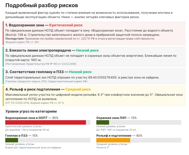
Following the enactment of Federal Law No. 218-FZ, personal property registry data was sealed from third parties. More critically, official paper registry extracts fail to reflect up to 70% of spatial, environmental, and infrastructure restrictions (such as high-voltage power line buffer corridors, flood zones, and industrial sanitary buffers).
Buyers routinely risk their life savings, receive a seemingly "clean" title extract, and only discover later that their land plot overlaps with a high-voltage utility easement where residential construction is strictly prohibited by law. I built NedvizhScan to eliminate this blind spot through automated geospatial intelligence and transparent due diligence.
What it does
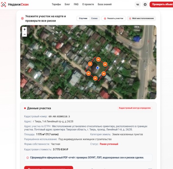
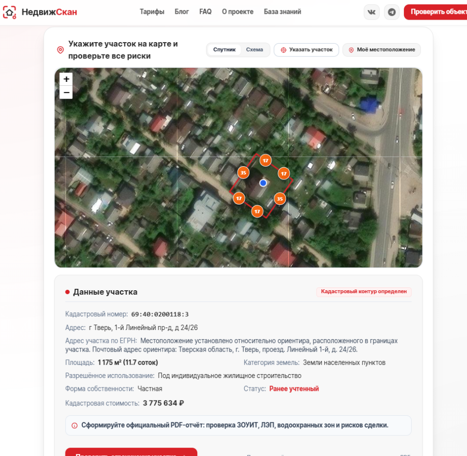
NedvizhScan is an automated spatial due diligence web engine for residential apartments, private houses, and land plots.
Within 30 seconds of entering an address or cadastral identifier, the platform queries 11 distributed state, spatial, and environmental datasets:
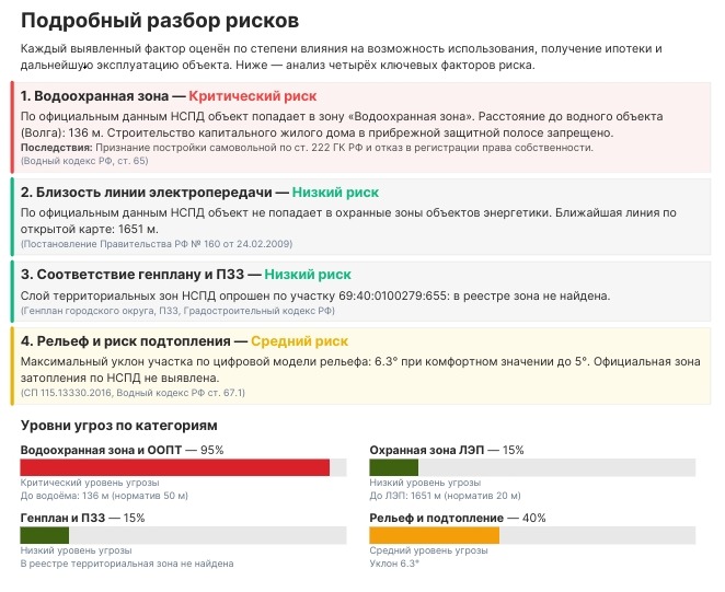
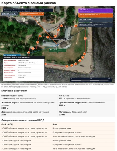
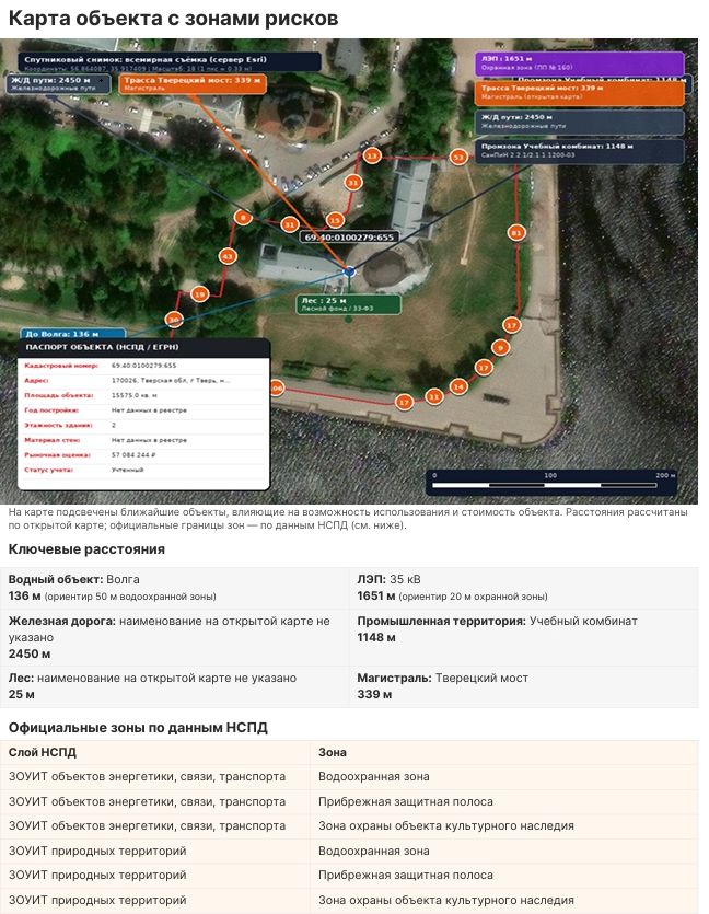
- ZOUIT & Utility Easements: Vector analysis of high-voltage power line corridors (Government Decree No. 160), gas pipeline buffers, and water protection boundaries (Water Code Art. 65).
- Hydrology & Flood Risk: Identifies flood-prone zones (Federal Law No. 301-FZ) using Copernicus GLO-90 digital elevation models to prevent construction in high-risk floodplains.
- Environmental Profiling: Evaluates ambient air quality (particulate matter PM2.5 and PM10, nitrogen dioxide) via Copernicus CAMS satellite monitoring and prevailing wind roses via Open-Meteo.
- Apartment Land Parcel Auditing: Automatically traces multi-unit apartment buildings back to their underlying land plot (Housing Code Art. 36) to detect industrial zoning conflicts and municipal expropriation risks.
- Objective Risk Index: Aggregates findings into an algorithmic Risk Score (1–100) and compiles a comprehensive 9-page analytical PDF report.
- Honest Data Manifesto: Every data source explicitly flags its integrity status (
available,no_objects,unavailable,not_queried) with zero fabricated synthetic scores.
How I built it
- Backend & Core: Asynchronous microservice architecture built with Python and FastAPI.
- Geospatial Processing: Spatial intersection pipelines utilizing GDAL, Shapely, and GeoJSON for vector geometry matching and coordinate transformation between local regional cadastral grids and WGS84.
- External Data Pipelines: Parallel distributed querying of the National Spatial Data System (NSPD), Rosreestr Public Cadastral layers, OpenStreetMap Overpass API (railway noise and social infrastructure graphs), Copernicus GLO-90 DEM, and Open-Meteo historical climate feeds.
- Reporting Engine: Headless document compilation engine generating structured 9-page analytical PDF reports complete with spatial visualization overlays, risk matrices, and legal check-lists.
Challenges I ran into
- Geospatial Discrepancies: Reconciling fragmented municipal GIS layers with federal cadastral datasets where utility buffer zones exist on town planning schemes but have not yet been recorded in central land books.
- State Geoportal Latency: Overcoming strict WAF rate limits, erratic network timeouts, and variable response schemas from public geoportals through aggressive caching, backoff strategies, and async worker pools.
- Resisting the "Synthetic Data" Trap: Unlike competitors that generate fictional "99% mortgage approval" metrics, I committed to strict data honesty: if a state registry is offline or requires manual notarized verification, the system reports it transparently.
Accomplishments that I'm proud of
- Achieving a complete multi-source spatial audit pipeline in under 30 seconds.
- Solving the "apartment blind spot" by bridging apartment records to the underlying ground parcel and surrounding environmental layers.
- Designing an intuitive 9-page PDF report that empowers non-technical homebuyers to make safe financial decisions before committing deposit funds.
What I learned
- Real-world spatial boundaries often diverge wildly from legal property descriptions.
- How to architect robust geospatial ETL pipelines capable of handling high-latency, rate-limited public APIs.
- The critical importance of transparent, verifiable data in YMYL (Your Money or Your Life) consumer products.
What's next for NedvizhScan — Real Estate Risk Analysis Platform
- Automated machine learning detection for historical boundary overlaps and unauthorized land shifts.
- Integration of natural radon concentration mapping and advanced industrial acoustic noise modeling.
- Developer API for PropTech platforms, mortgage lenders, and real estate legal practices looking to embed instant spatial audits.
- Explore the live platform: nedvizhscan.ru.
