Munich Pathfinder: Rethinking Navigation
Inspiration: Safety First, Sustainability Through Trust
Cities like Munich promote sustainable mobility, yet everyday behaviour shows a different priority: safety outweighs all other considerations. People avoid biking or walking when a route passes through accident hotspots, poorly lit segments, or streets linked to elevated crime risk—even if that choice conflicts with environmental goals.
This persistent gap between mobility policy and personal risk perception led us to a central question: What would it take for people to trust sustainable mobility if the city itself contains segments they actively try to avoid?
We examined common situations: bike routes with a history of crashes, pedestrian paths that feel unsafe after dark, and neighbourhood shortcuts that remain unused because people lack tools to identify and avoid high-risk segments. These everyday frictions quietly undermine the shift toward sustainable behaviour.
This pushed us to rethink routing at its core. What if navigation prioritised risk reduction as a first-class objective? What if accident data, lighting proxies, and activity-level indicators became part of the routing logic? What if we could compute routes that actively steer people away from dangerous, uncomfortable, or low-visibility areas, and towards segments where they feel protected?
The insight was simple: Sustainable mobility only succeeds when people feel safe using it.
Our goal became to support climate-neutral movement by delivering routes that maximise safety, reinforce trust, and make everyday walking and biking fundamentally more secure & enjoyable.
That became Munich Pathfinder.
The Solution: Three Smart Modes, Real Impact
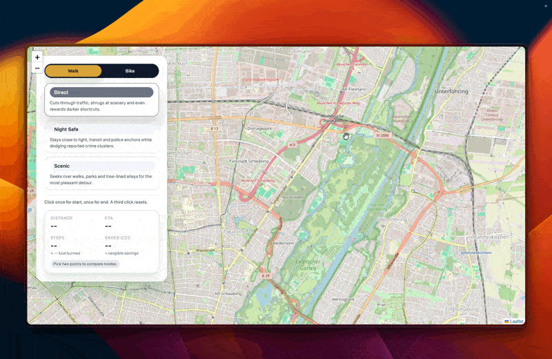
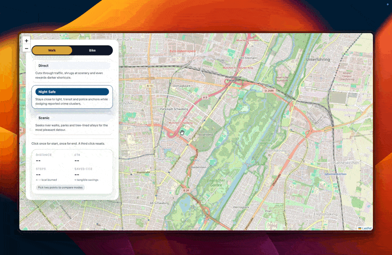
Standard navigation optimizes for one thing: Speed and Efficiency. Munich Pathfinder offers walking and biking routes optimized for how movement through the city is actually felt, turning every commute into a conscious, rewarding choice.
| Mode | Focus | The “Why” |
|---|---|---|
| Direct / Bike Direct | Efficiency. The shortest, most practical path. | For fast, no-nonsense movement. |
| Night Safe / Ride Safe | Visibility & Security. Lit streets, low crash density, low-risk segments. | For evenings and late returns. |
| Scenic / Bike Scenic | Calm & Comfort. Parks, rivers, tree-lined streets, protected bike ways. | For discovery and well-being. |
The Tangible Feedback Loop
Gamification: Route choices are made concrete and motivating through measurable feedback:
- CO₂ Saved vs. a car trip — environmental benefit made tangible.
- Energy Metrics — Steps + kcal (Walk) / Wh + kcal (Bike).
- Comparative Mode Statistics — showing percentage differences between modes.
By revealing the true cost of the “fastest route,” the system often uncovers that the apparently unattractive alternative is actually the one users prefer.
Technical Deep Dive: A Transparent Cost Model
We built a two-layer, enrichable City Graph combined with a transparent cost model — designed from the ground up to be traceable, interpretable, and extensible.
Pipeline: Open Data → Intelligent Graph
1) Graph Building Two separate graphs for Walking and Biking, reflecting their different risks, speeds, and infrastructural constraints.
2) Data Enrichment We fused OpenStreetMap with Munich Open Data to assign per-street attributes:
- Safety Proxies: accident density, lighting proxies, active-segment indicators, crime-associated zones.
- Comfort Proxies: greenery density, distance to parks or water, traffic/noise exposure.
Each proxy becomes a measurable numeric feature on the graph.
3) Routing Core A transparent and tunable cost function combines these features: (W dist, W safe, W green, W comfort). It allows fine-grained optimisation and is future-proof for ML-based refinement.
Key Innovation: The Learning Architecture
Our architecture blends statistical learning with interpretable optimisation:
1. Data-trained Segment Scoring
Street-level features are not hand-waved or declared arbitrarily. They are computed empirically from the city’s raw datasets:
- Accident records → Crash likelihood field (via smoothing + density estimation)
- Lighting proxies → Visibility estimate
- Crime-linked zones → Contextual risk score
- Green & water corridors → Comfort gradients
The city’s data shapes the evaluation function of each street segment.
2. Simulation-based Statistical Validation
To ensure the model behaves consistently, we introduced a statistical route-validation pipeline:
- We generated thousands of simulated routes across diverse city profiles.
- For each route, we computed its predicted attributes (safety, green exposure, comfort).
- We compared these predictions with the feature distributions of the underlying graph.
- Using regression-style consistency checks (feature → outcome), we quantified how reliably a selected mode actually fulfils its intended goal.
The result: Across simulations, over 90% of routes selected in a given mode reached the expected safety/comfort/green criteria. This demonstrates that the model does not just “intend” to optimise safety or greenery—it consistently produces routes aligned with those objectives.
3. Modular & Scalable
Because the cost function is cleanly separated from the data, the entire engine can:
- plug into new datasets,
- adapt to new cities,
- integrate machine learning models once real user data becomes available.
Impact: Quieter, Safer, Greener Cities
Munich Pathfinder delivers on three fundamental goals:
Personal Safety Safer, better-lit, lower-risk routes — especially at night.
Wellbeing Movement along calmer, greener, more enjoyable urban corridors.
Environmental Action Gamified metrics turning sustainable choices into daily habits.
If enough people regularly choose “a few minutes slower, but safer and greener” over “fastest at all costs,” the aggregate effect meaningfully shifts how Munich feels — and simultaneously strengthens environmental outcomes. This is human-centric routing for real cities.
What We Learned
- Hackathons are demanding, but pushing through the breaking point creates the breakthrough.
- Communication is everything — aligning assumptions early avoids hours of rework.
- Enjoy the process and free Food :)

Log in or sign up for Devpost to join the conversation.