-
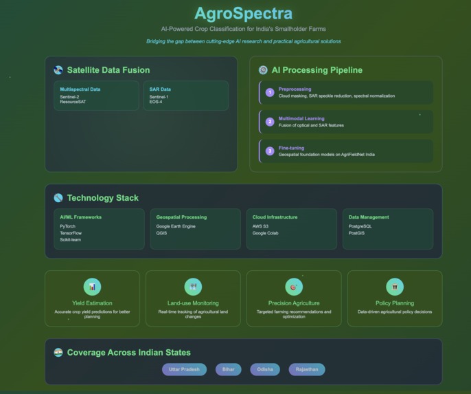
Project Workflow

Inspiration
Indian agriculture is dominated by smallholder farms, which are fragmented and diverse in their cropping practices. Unlike large farms in the USA or Europe, this creates unique challenges in crop identification. We were inspired to leverage AI + multispectral + SAR satellite data to build a solution tailored for India’s farming landscape.
What it does
AgroSpectra is an AI-powered system that classifies crop types across smallholder farms using multispectral (Sentinel-2, ResourceSAT) and SAR (Sentinel-1, EOS-4) observations. It provides accurate, scalable crop maps that support yield estimation, precision agriculture, and land-use monitoring.
How we built it
- Collected satellite data (Sentinel-1, Sentinel-2, ResourceSAT) and combined it with AgriFieldNet India ground-truth labels.
- Preprocessed the data using cloud masking, SAR noise reduction, and spectral normalization.
- Fine-tuned geospatial foundation models to Indian conditions.
Challenges we ran into
- Fragmented farmland boundaries complicated segmentation.
- Seasonal crop growth variability reduced classification accuracy.
- Integrating SAR + optical data required complex preprocessing.
- Managing large-scale satellite imagery demanded high computation.
Accomplishments that we're proud of
- Successfully fused SAR + multispectral data into one pipeline.
- Adapted global foundation models for India’s fragmented farms.
- Built a system that generalized across Uttar Pradesh, Bihar, Odisha, and Rajasthan.
- Demonstrated scalability for nationwide crop monitoring.
What we learned
- The power of multimodal satellite data for robust crop classification.
- Importance of locally collected labels for accuracy.
- Advanced preprocessing techniques for noise reduction and temporal alignment.
- How to balance global AI techniques with local agricultural realities.
What's next for Multispectral + SAR crop classification for small farms
- Expand coverage to more crops and regions in India.
- Automate preprocessing pipelines for real-time deployment.
- Develop a farmer-facing dashboard for accessible insights.
- Integrate real-time weather and IoT data for dynamic crop monitoring.
- Partner with governments and NGOs for large-scale adoption.
Built With
- amazon-web-services
- and-hugging-face-was-utilized-for-adapting-geospatial-foundation-models.-spatial-data-management-was-handled-through-postgresql-with-postgis
- enabling-efficient-querying-of-farm-boundaries-and-crop-data.-on-the-data-side
- gdal
- google-colab
- google-earth-engine
- hugging-face
- leveraging-deep-learning-frameworks-like-pytorch-and-tensorflow-along-with-scikit-learn-for-model-training-and-evaluation.-for-geospatial-data-handling-and-preprocessing
- postgresql-with-postgis
- python
- pytorch
- qgis
- rasterio
- scikit-learn
- sentinel
- tensorflow
- we-integrated-the-sentinel-hub-api-for-sentinel-1-and-sentinel-2-imagery
- we-used-gdal-and-rasterio
- while-google-earth-engine-and-qgis-supported-large-scale-satellite-imagery-analysis-and-visualization.-cloud-services-such-as-aws-s3-for-data-storage-and-google-colab-for-model-training-provided-scalability
