-
-
MooTrack

Inspiration
I was born and raised in the lush green heart of the Western Ghats in the Mookambika Reserved Forest of Karnataka. My childhood was filled with misty mornings, the sound of rustling leaves, and the gentle bell-tinkling of cows grazing near our ancestral home.
But among these serene memories, there was always one shadow that loomed over us leopard attacks. Our cattle, who are considered family in rural households like mine, would often stray into forested areas and never return. Sometimes, leopards would enter our village, snatching away not just cows but also the beloved dogs that guarded our homes.
I’ve seen my grandparents cry over lost animals not because they were assets, but because they were companions. That helplessness, that quiet grief, lit a fire in me. MooTrack is my response - a blend of compassion, technology, and a mission to bring safety back to the people and animals who raised me.
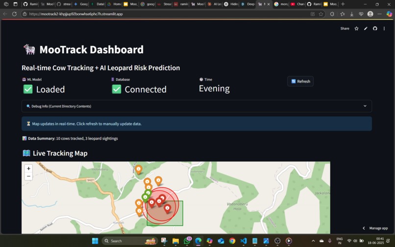
What it does
MooTrack is an AI-powered, cloud-based solution designed to:
- Track cattle in real-time using GPS-enabled collars
- Detect when cattle wander near forest zones
- Predict leopard risk using AI models trained on wildlife sighting data
- Alert farmers instantly through mobile or SMS notifications when danger is near
- Display a dashboard with cattle paths, forest boundaries, and threat zones
It's not just about location; it's about understanding patterns, preventing losses, and building trust between man, animal, and machine.
How we built it
GPS Tracking & Geofencing Used Streamlit + Python for the frontend interface Simulated cow movement using simulate.py to represent real-time GPS data Geofenced forest areas to trigger alerts
AI Model (ML) Trained an Linear Regression model on a custom risk_dataset.csv with historical environmental and location data Feature-engineered elements like time of day, location proximity, and previous incidents Exported and used risk_predictor_model.pkl for real-time inference
Backend & Alerts Built the backend using Python and MongoDB Atlas for storing cattle data Integrated Twilio API to send alerts when danger conditions are met Cleaned and secured the deployment via .env and Streamlit Secrets Manager
Hosting & Deployment Deployed using Streamlit Cloud Hosted GitHub repository for version control and collaboration MongoDB Atlas handles all our data:
- GPS time-series logs
- Leopard sighting datasets (from GBIF)
- Forest boundary geolocation
- Risk prediction results
- Geospatial queries check whether cattle have entered danger zones. Alerts are triggered via a simple notification system — future-ready for integration with Twilio
Challenges we ran into
MongoDB authentication issues on Streamlit Cloud despite working locally learned to double-check secrets formatting and URI encoding
Twilio push protection blocked commits until secrets were removed and handled securely
Balancing model accuracy with real-time performance under limited data conditions
Managing file structure and virtual environments in Git while avoiding large .venv folder commits
Resolving merge conflicts and git push errors due to differing branches and commits
Accomplishments that we're proud of
What makes me most proud of Mootrack isn’t just the tech - it’s the purpose behind it. I didn’t just build an app; I created a system that could save someone’s livelihood.
I’m proud that I:
Translated a real-world rural issue into a working tech solution
Designed and trained an AI model from scratch, understanding both the hardware and ML logic
Deployed an end-to-end full-stack system solo, handling everything from frontend UX to cloud deployment
Navigated technical hiccups like Git push protection, secret management, and MongoDB auth errors, and still got it working on Streamlit Cloud
Pitched the project with confidence, knowing it reflects both engineering rigor and empathy-driven design
This is more than a project -it’s a promise that I can engineer solutions that matter.
What we learned
Hands-on experience integrating MongoDB Atlas with Python and Streamlit
Best practices in managing secrets, including escaping credentials and dealing with push-protection errors
Model training and evaluation, and deploying it in a real-time system
Importance of geospatial logic, real-time systems, and reliable alerts in safety-critical applications
Cloud deployment challenges and how to troubleshoot bad auth and URI formatting issues
What's next for MooTrack
Field Deployment: Collaborate with forest departments or local NGOs to test the prototype in a real rural setup.
Hardware Integration: Develop low-cost, durable GPS collars for actual cattle.
Community Reporting: Add functionality for farmers to report wildlife sightings directly.
Edge Computing: Use Raspberry Pi or ESP32 modules to push AI logic closer to rural areas.
Multi-animal Expansion: Extend to goat, sheep, and even pet tracking in rural zones.
I'm deeply passionate about using technology for ecological harmony and this project is a step in that direction.
Built With
- folium
- gcr
- github
- gnss
- google-cloud
- joblib
- mongodb
- pandas
- python
- scikit
- scikit-learn
- streamlit
- twilio

Log in or sign up for Devpost to join the conversation.