Inspiration
We wanted to explore how real-time intelligence could be used to solve a practical problem using open data. While looking for a use case that combined real-time data, geospatial analytics, and AI, we discovered that aviation provides a rich ecosystem of publicly available data.
We were inspired by the possibility of combining live aircraft positions, flight routes, and aviation weather hazards to answer a simple but important question:
“What if we could automatically identify which flights are likely to be affected by a weather hazard and warn them in real time?”
This idea led to AeroGuard AI — a real-time aviation intelligence platform that brings together aircraft tracking, weather hazard detection, geospatial analysis, and generative AI.
What it does
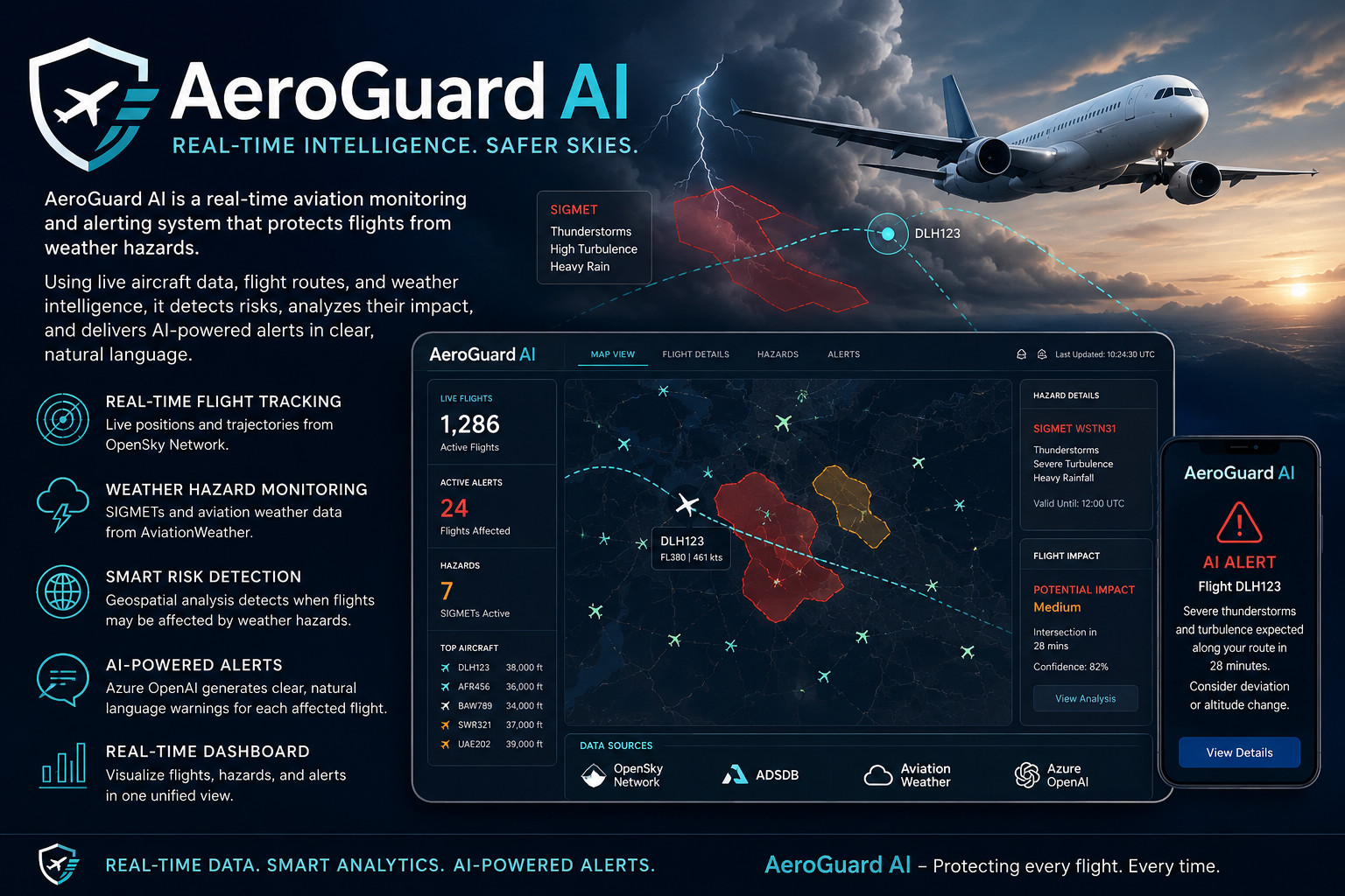
AeroGuard AI continuously monitors aircraft and aviation weather conditions to identify potential risks to flights.
The system combines data from OpenSky Network, ADSDB, and AviationWeather to understand:
- Where aircraft are currently located
- The routes they are following
- Where significant weather hazards are present
- Whether a flight could be affected by a particular hazard
Using geospatial analysis, AeroGuard AI checks whether aircraft trajectories intersect with SIGMET hazard areas.
When a potential risk is detected, the system generates an alert and uses Azure OpenAI to convert technical weather information into a clear, natural-language warning that can be tailored to the affected flight.
A real-time dashboard allows users to visualize aircraft, flight routes, weather hazards, and active alerts in one place.
How we built it
AeroGuard AI was built using Microsoft Fabric Real-Time Intelligence as the core data platform.
The architecture follows a real-time intelligence medallion architecture:
Data Sources → Notebooks → Eventstream → Eventhouse → Silver Layer → Gold Layer → AI Alerts & Dashboard
Data ingestion
We retrieve aviation and weather information through web APIs using notebooks. The data is then sent through Eventstream and ingested into a Fabric Eventhouse.
Data processing
The raw data is organized into different layers:
- Bronze: Raw aircraft, route, and weather data
- Silver: Cleaned and transformed data using update policies
- Gold: Enriched information used for analytics, visualization, and alert generation
Geospatial intelligence
Materialized views are used to perform real-time processing, including:
- Creating geographic geometries
- Processing aircraft trajectories
- Representing weather hazard areas
- Detecting intersections between routes and hazards
- Tracking active alerts
- Aggregating the latest flight information
We worked with geospatial formats such as GeoJSON and WKT to represent aircraft positions, flight paths, and hazard zones.
Generative AI
When a potential flight hazard is identified, the relevant information is passed to Azure OpenAI.
The AI converts the technical information into a meaningful warning message that is easier for a pilot or aviation stakeholder to understand.
Visualization and alerting
A real-time dashboard displays aircraft positions, routes, weather hazards, and detected risks.
The alert pipeline can also send generated warnings through Reflex to notification channels such as email or Microsoft Teams, depending on the available environment.
Challenges we ran into
One of our biggest challenges was real-time API ingestion. We initially explored calling web APIs directly from Eventhouse using KQL, but the available functionality was not sufficient for all our ingestion requirements. We therefore used notebooks to retrieve and process the external API data.
We also encountered limitations with Azure OpenAI access and rate limits. In a real-time aviation scenario, multiple flights may require alerts simultaneously, but the available rate limits made it difficult to process every alert immediately.
Another limitation was the availability of communication channels in our development environment. Since we were working with personal Azure/onmicrosoft accounts, we could not fully test integrations with Teams and Outlook.
We also wanted to experiment with text-to-speech, which could potentially turn generated warnings into spoken alerts. However, the required model was not available in our hackathon environment.
Additionally, Copilot capabilities were not available in our Fabric trial environment, limiting some of the AI-assisted features we wanted to explore.
Finally, aviation is a highly specialized domain. Since we were not aviation experts, understanding SIGMETs, flight operations, and the appropriate interpretation of weather hazards was itself an important learning challenge.
Accomplishments that we're proud of
We are proud of building a complete real-time aviation intelligence pipeline within the limited time and resources available during the hackathon.
Instead of creating a simple dashboard, we developed an end-to-end system that connects:
Live Data → Real-Time Processing → Geospatial Analysis → Risk Detection → Generative AI → Intelligent Alerts → Visualization
We successfully brought together multiple independent aviation data sources and demonstrated how Microsoft Fabric can process and analyze them in a real-time environment.
We are particularly proud of the ability to identify potential interactions between flight trajectories and weather hazard zones and then transform those technical findings into understandable AI-generated warnings.
What we learned
This project was our first experience building a complex solution focused specifically on real-time intelligence.
We gained practical experience with:
- Microsoft Fabric Real-Time Intelligence
- Eventstream and Eventhouse
- KQL
- Real-time data processing
- Medallion architecture
- Geospatial analytics
- GeoJSON and WKT
- Materialized views
- Generative AI with Azure OpenAI
- Real-time alerting architectures
- Integrating multiple external APIs
We also learned that building a real-time system involves more than simply processing data quickly. Data ingestion, latency, API limitations, rate limits, data quality, geospatial accuracy, and domain knowledge all play an important role.
Most importantly, AeroGuard AI showed us how real-time data and generative AI can work together to transform raw information into actionable intelligence.
What's next for AeroGuard AI
We see AeroGuard AI as a foundation that can be expanded into a more intelligent aviation decision-support platform.
Our next steps include:
🔊 Text-to-Speech Alerts
Enable AI-generated warnings to be converted into speech, allowing alerts to potentially be delivered as voice messages.
🤖 RAG-Powered Aviation Assistant
Build a Retrieval-Augmented Generation (RAG) architecture that allows users to ask questions such as:
“Which flights are currently approaching severe weather?”
“What hazards are affecting this flight route?”
“Why was this flight flagged?”
The assistant could use real-time flight and weather information to provide contextual answers.
🔮 Predictive Risk Analysis
Move beyond detecting current intersections and explore whether a flight may enter a hazard zone in the future, providing earlier warnings.
📡 Improved Real-Time Processing
Optimize ingestion and alert processing to handle larger numbers of aircraft and simultaneous hazards while reducing latency.
📊 Enhanced Dashboard
Add more advanced flight analytics, historical hazard information, risk scores, and detailed flight-impact visualization.
☁️ Production-Ready Architecture
Replace some of the hackathon-specific workarounds with a more robust production architecture designed for scalability, reliability, and continuous real-time operation.
Ultimately, our vision is for AeroGuard AI to evolve from a monitoring system into an intelligent aviation safety and decision-support platform, helping aviation stakeholders understand risks faster and make better-informed decisions.
Built With
- ai
- deeplearning
- eventhouse
- eventstream
- fabric
- github
- kql
- machine-learning
- notebook
- openai
- pipeline
- powerbi
- python


Log in or sign up for Devpost to join the conversation.