-
-

Current Challenges
-
Unique Solution
-
Admin Solutions
-
Other Solutions
-
Geozones Management
-
Set Geozones
-
Citizen Location Awareness
-

Real Time Dashboard
-
Case Management
-

UN Development Goals
-
Next Steps
-

Are You Ready
-
Citizen Views


The problem your project solves
We look at the problem as follows: 1 / Current Management of the epidemic 2 / Future challenges as lockdown guidelines are relaxed 3 / Time to Deploy and Scale, Backend Administration and End User Training 4 / Cost of Solution Development, Scale-Up and Maintenance
1/ Gov, Local Administration, Medical Staff is challenged with
- Tracking Community Cases and Monitor home-based quarantines
- Limited bandwidth down the line with Staff working remotely to maintain social-distancing
- New tools present training challenges for front line workers
- Associated public fear with the corona-virus epidemic.
- This is an ongoing effort, and several countries have lockdown guidelines enforced to ensure social distancing.
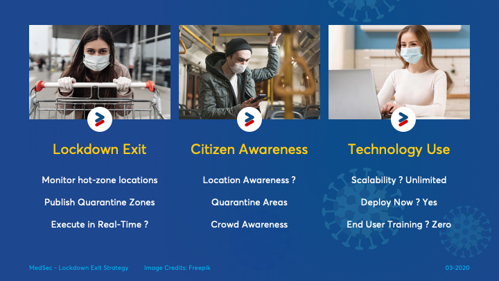
2/ as we move out of lockdown, it presents additional challenges for Gov, Local Administration, Medical Staff and Citizens -Able to monitor small locations which could be multiple apartment complexes, and localities across a city (and hence across an entire country)
- Manage and Publish Quarantine Zones on a real-time basis
- Information Awareness on areas to avoid and crowd in a certain location
Most of the solutions are built in a traditional setup with location-based features as an add-on - we built MedSec with location as the core technology
3/ MedSec provides a Hand-free operating setup - with (near) zero user training. 4/ Solution can be operated at an optimum cost of €1 per person per month
The solution you bring to the table
MedSec provides real-time location based intelligence to Gov and Administration who are managing the corona virus in an area. MedSec is a comprehensive solution and the key innovation is the automation using location data. Compared to any traditional software setup.
USP
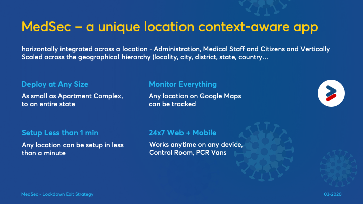
MedSec is a Hyper-Local solution and allows us to set up monitoring for any location on earth in less than a minute. This unique automation makes it a superior technology solution, provides unlimited scalability and lightning fast deployment speed.
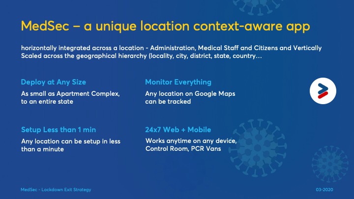
The solution is horizontally integrated across a location - Administration, Medical Staff and Citizens and Vertically Scaled across the geographical hierarchy (locality, city, district, state, country…. )
Add Admins - One only needs to add Name, Mobile Number and Search the Location (like searching for a destination in Google Maps) to setup for a location.
So if someone is added as City Admin, and next someone is added as a State Admin, the geographical hierarchy will set the make the City Admin a Team member of the State Admin and make the state admin as the superior. All people who are joined into a location (via the app will come under this jurisdiction) hence no manual data entry
For Setting up a Geozone - we need to search for only the location on Google Maps and set a boundary in km.
The application builds itself up as more admins, citizens (users) are added, without anyone having to deal with complex backend tasks.
What Does this Mean ? The immediate benefit of this is that there is no need to assign people, admins, facilities to a database using dropdown boxes - Select Country, Select City, Select Locality….. This removes heavy backend administration tasks saving significant amount of time
MedSec automates the entire process - once Home Location is set (3-step onboarding), following things happen automatically:
- Location Context Aware Monitoring - with Maps based interface
- Admins are automatically setup to their locations and get visibility of citizens
- State, Country Admins have visibility down the geographical hierarchy
- Automate resource management - team assignments, facility management and inventory accounting
- Automate Reporting tasks via geographical roll-up of data
- Automatically added to location chat groups - connect to people in an area - no admins needed
Publish Announcements for citizens in a specific location - correct information, deliver in real-time
Citizen Home Quarantine can be done automatically
Citizen is automatically added to local community chat rooms
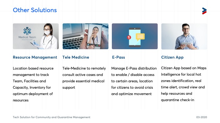
Other services - hospitals, helplines, volunteers, essential services can be easily mapped in a hyperlocal environment
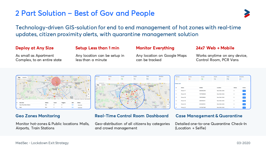
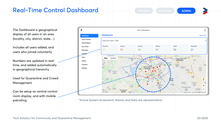
Solution Components Dashboard is for use by local administration and medical staff. It provides an instant snapshot on the corona cases in a particular location and assists with decision making.
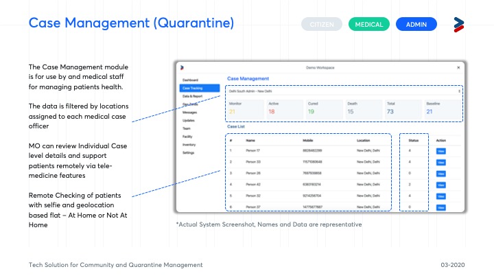
Case Management module is for use by medical staff for tracking and managing patients' health. This also enables tracking self-quarantine cases remotely
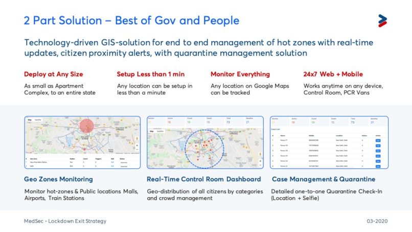
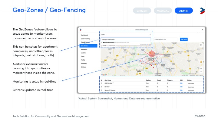
GeoZones feature allows administrators to set up hot zone areas and monitor the movement in and out of such zones. This can also alert citizens who are approaching such areas and provide timely alerts.
Data Reporting module allows data capture in real-time from a distributed network of admins and medical staff. Data is reported against geo-location and rolled up to provide statistics across geographical hierarchy. They can setup restricted zones (hot-zones) - which trigger automatic notes via Geo-Fencing alerts.
MedSec Citizen app is a single interface for the people. It allows to register multiple profiles, linked to a mobile number and build on local expertise within every community. Once home location is set, users get personalised help, feed, updates and participate in local community chat rooms.
Poeple can join as volunteer, doctors, pharmacie, grocery stores and other profiles - to supercharge the local ecosystem - and yet being able to maintain the social distancing guidelines.
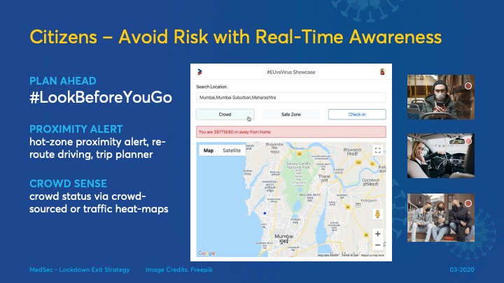
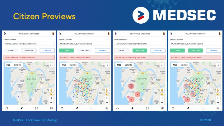
Citizens can look up the area around them and see real-time updates before moving out of their houses and during transit. (part of the demo submission)
What you have done during the weekend
We have use the time productively to:
- Enjoy working in a remote team and witness the collective power of the human race who come together across boundaries to solve a crisis of this scale
- Review current solutions and several others proposed in the hackathon - found some synergies with other projects and look forward to collaborate with them
- Communicate with mentors, other users and local administration teams in india to understand challenges - this includes talking to people in various levels of state department - Operations, Health, IT etc
- Learn from experts in several online sessions on different topics - remote working, product management, build human interfaces
- Learn more about technology, maps and Reach out to Google and Here (Maps) for Credits to build a cost effective solution
- Integrate, build and improve the solution during the hackathon
The solution's impact to the crisis
Dealing with any crisis requires Eyes-On - information in real-time. MedSec provides the required visibility to enable decision making.
MedSec does not lock down vital information in some database or machine - it makes them available to those who need it, when they need it. This alone is a significant impact to managing the pandemic. For example, consider the following:
The Citizens View Show Restricted zones on a map and other cases in nearby location, which can be used route planning and planning for time spent outside their homes.
The necessities in order to continue the project
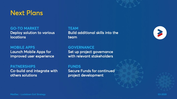
We have built the core solution and look forward to the following
- To deploy the solution (it can be deployed at small country, city, a state - any location) - we can do a small demo
- Setup Project Governance with stakeholder participation from Gov, Health, Public Policy, Technology, Citizens (mentoring) and mentors
- Partnership across different geographics for deployment and governance
- Partnership with other solutions - one of our key objectives is to integrate with other solutions (we have reached out to few team in the hackathon)
- Funding Support for project maintenance and deployment
The value of your solution(s) after the crisis
The crisis does not seem to be over soon - and lifting lockdown measures are not indicative of the eradication of the virus. The easing of movement needs to happen in phases as some zones will continue to be active.
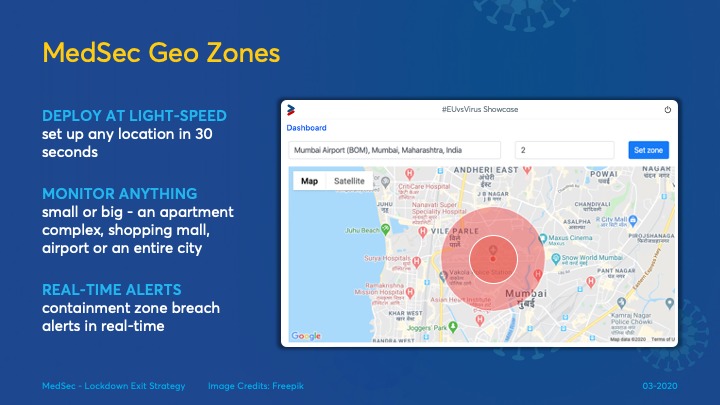
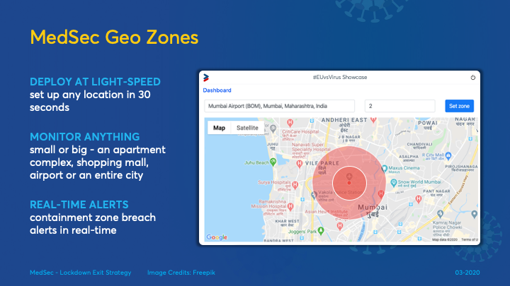
MedSec allows creating restricted geo-zones - for any location - as small as an apartment complex and displayed in “real-time” on google maps in less than 1 minute A number of such zones can be setup - in a city or across the country - if a location or building (POI) exists on google maps (or maps database)
For Gov and Local Administration They can review the movement in real-time and visualize information of how many citizens are inside the containment area and how many are crossing in/out of the zone. Hence they can take real-time action, and they can review this via control rooms instead of positioned in dangerous areas themselves.
For Citizens Citizens can get a real-time status of any particular area - including restricted zones and crowd outside. This is done without sharing personal information - only position markers of citizens. They can plan their driving routes to avoid such areas.
Beyond COVID The solution can be applied beyond COVID for crowd-management and maintenance of restricted zones - in any scenario of communicable diseases.
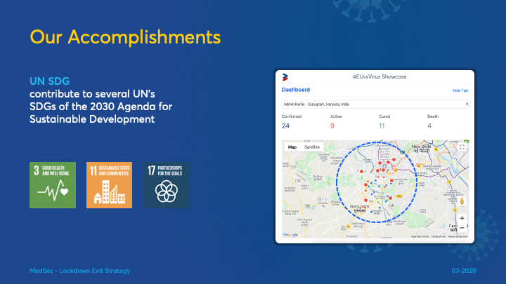
The solution lives beyond the current crisis and in support to implement the UN Strategic Development Goals.
- Goal 01: No poverty
- Goal 11: Making cities inclusive, safe, resilient and sustainable
- Goal 17: Partnership for the Goals
Contact
Saurav Raaj email: saurav.raaj@gmail.com

Log in or sign up for Devpost to join the conversation.