-

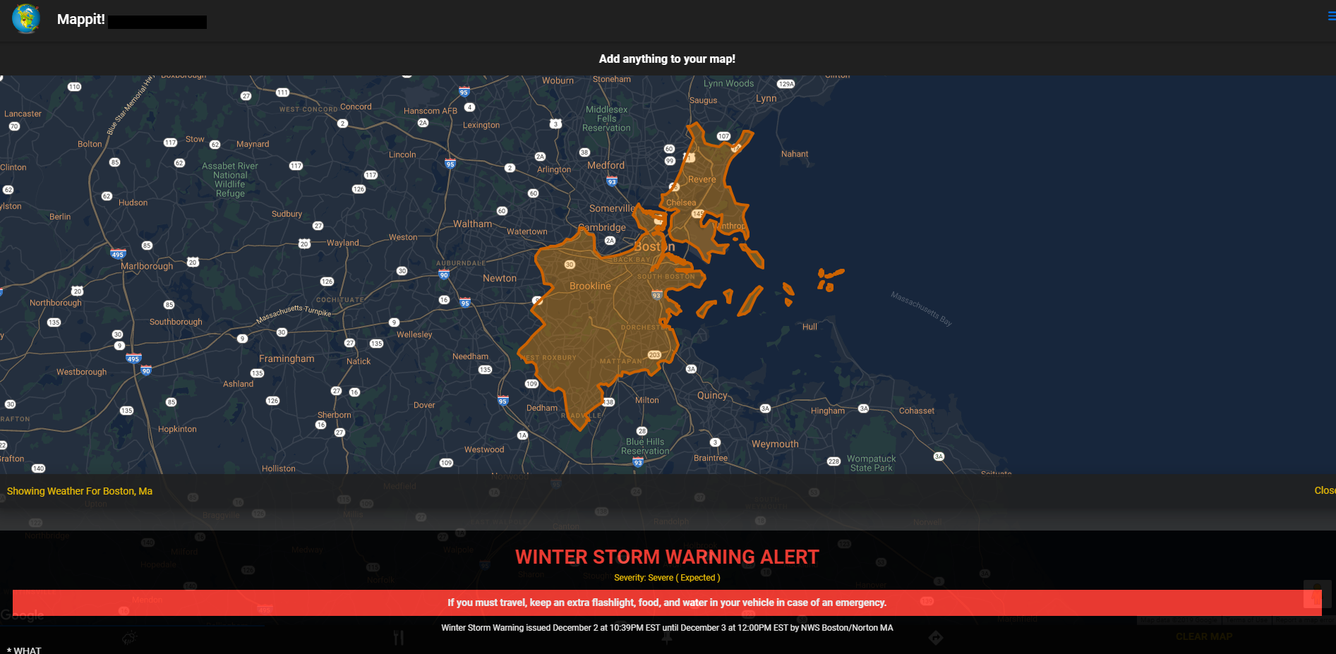
Severe weather alert example (desktop)
-

Severe weather alert example (desktop)
-

-

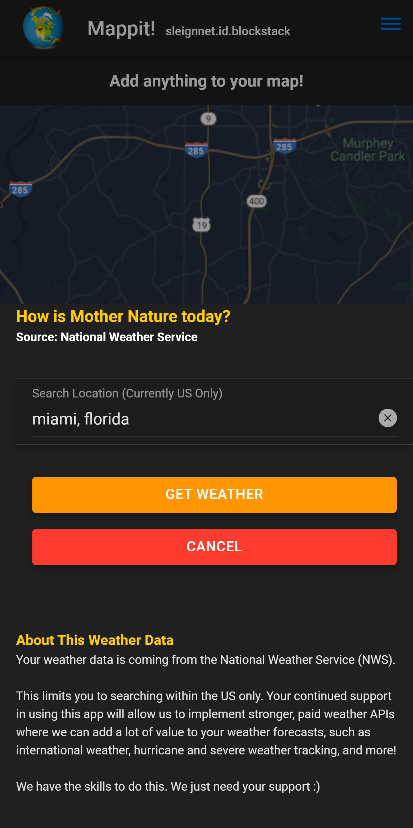
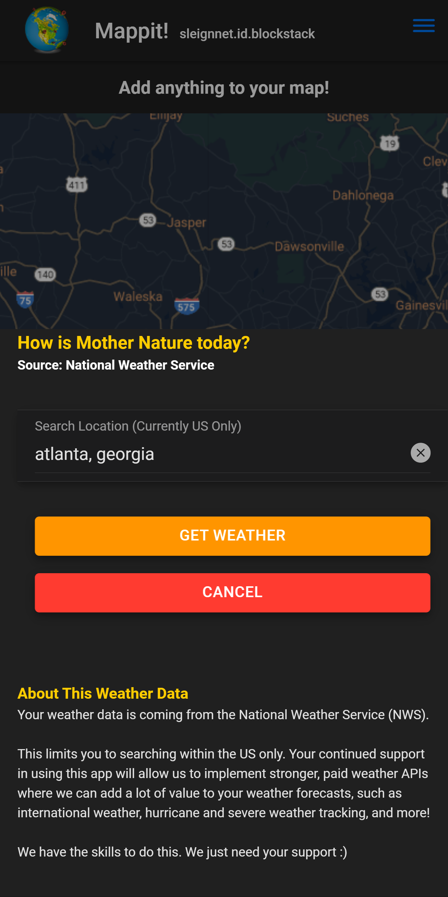
Weather forecast search form
-

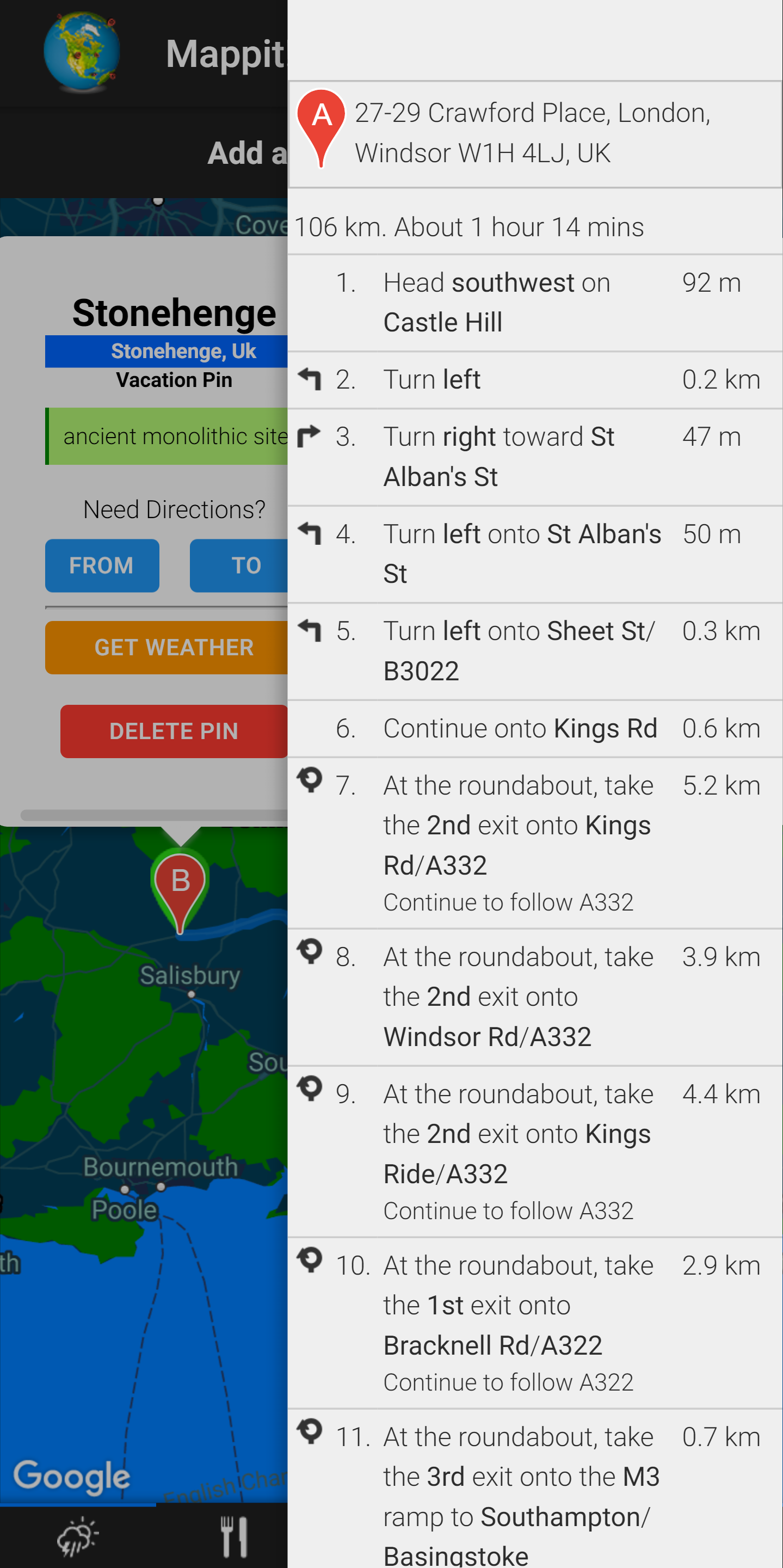
Directions
-

User submitted restaurant photos from restaurant search
-

Custom pin example
-

"See Details" screen from restaurant search pin
-

Local weather forecast
-

Restaurant search result pin


Inspiration
I have been working with Google Maps and in the travel and safety industry at an enterprise level for about 10 years. I have not seen a whole lot in the way of mapping applications on Blockstack, so I thought I'd contribute a little bit :)
What it does
Mappit! is a mobile-first, extremely versatile, 100% anonymous and decentralized Google Maps application.
Search for local weather anywhere in the United States (international coming soon!)
- Draws forecasted area on the map in detail
- Displays scrollable 7 day forecast
- Mappit! automatically scans the same forecasted area for any severe weather alerts and will display them before the standard weather forecast. This includes any special instructions issued by the National Weather Service.
- Get local weather from any custom or restaurant pin with the click of a button!
View locations of fires worldwide thanks to NASA!
- Uses NASA VIIRS I Band 375 m Active Fire Product NRT satellite data
- All satellite data is stored in Gaia for decentralization purposes
- Satellite data has been refined to show only fires with a high degree of certainty from readings
- USGS fire data and their precise boundaries also depicted in the contiguous United States
- Fires can be clustered or displayed individually on the map
- Your satellite data in Gaia will automatically refresh itself when viewing fires if the data is more than 3 hours old. This keeps you up-to-date with the latest satellite scans! (Scans have a 3-5 hour latency period each)
See realtime earthquake data over the last 24 hours!
- US Geological Survey data shows when and where earthquakes have occurred over a rolling 24 hour period.
- All earthquakes displayed are within the last 24 hours
- Earthquakes can be clustered or displayed individually on the map
- Earthquake icons are color coded based on the magnitude of the earthquake. Light ones are green, while more severe ones are yellow and red.
Search locations of restaurants worldwide with Zomato
- See contact information for restaurants
- Shows a list of descriptive keywords to give an overall idea of the restaurant
- User submitted images for each restaurant, if available
- Links to the menu from the restaurants if available (external link, but no account required)
Create custom map pins
- Pin data is saved to Gaia, ensuring your data is decentralized
- Categorize your pins so you can view only the pins you want to see
- Add a title and some notes to each pin (optional)
- Drag the pin anywhere on the map before saving to have a more exact location
- Pins can be deleted at any time by clicking on the marker and selecting "Delete"
Get directions
- Get directions from Point A to Point B
- Get directions between custom pins you create with the click of a button
- Get directions between your custom pins and restaurant pins from Zomato with the click of a button
All data is STACKABLE!
- All data (fires, restaurants, pins, etc) will stack on the map as you use the application. You can clear your map at anytime using the "Clear Map" button in your bottom toolbar. This enables you to have more robust information by adding whatever you want to the map - without it clearing on you each time you add something!
- All data (fires, restaurants, pins, etc) will stack on the map as you use the application. You can clear your map at anytime using the "Clear Map" button in your bottom toolbar. This enables you to have more robust information by adding whatever you want to the map - without it clearing on you each time you add something!
Idea behind stackable data: Let's take the idea of going on a vacation. Create some custom vacation pins to mark those must-see tourist attractions. Add more custom pins to mark highly rated restaurants and parking locations near your vacation pins in advance of your trip -- so you don't spend your precious vacation time searching for a nearby place to eat or someplace to park.
Not sure what the weather will be like when you arrive? Click on any custom pin to get the local weather forecast for that area (US only, for now). Not sure how to get from one tourist attraction to the next? Each custom pin has a "to" and "from" button for directions. Click on either (let's say "to" for this example), and it will automatically add the exact coordinates of your pin to the "to" field in your directions form. Click on the second custom pin and and click "from" and it will do the same for the "from" field in your directions form. No need to type in those lengthy addresses or switch between screens to copy/paste!
How I built it
I've found that keyboards help a LOT.
Challenges I ran into
I think user education on the way Mappit! interacts with various APIs -- especially coming from Google - is the toughest challenge with this. Most people think they're being tracked the second they see something from Google. Some may also be confused about what decentralization really is vs anonymous API requests. The app is easy and straight forward to use, but obtaining the level of faith from the user to know that, without question, their information and usage is not being tracked is another deal altogether, so it all boils down to user education.
For that reason, I built an FAQ section that explains how these processes work in a way that hopefully both novice and more advanced users can understand.
Accomplishments that I'm proud of
I did 95% of all of this in about 15 days in my spare time. I would have gone further but it's the holiday season and I had family coming to visit. There is a lot more coming soon though :)
What I learned
It is possible to write a decentralized application around Google Maps while retaining 100% user privacy. See more info in the FAQ page of Mappit! to see how this is done
What's next for Mappit!
Lots.. International weather forecasts, hurricane and earthquake data, more restaurant providers so we're not dependent on a single provider (thus also being susceptible of biased of information), ability to create your own categories and designate icons for custom pins, ability to convert a restaurant search pin into a custom pin with a single click, international travel advisories that visibly change the color of each country on the map according to its alert level, geo-specific news articles, and better infowindow design for custom pins to start.
Mappit! focuses on two main categories - travel and safety. There is a parallel between these two worlds, and that is where I want Mappit! to live.

Log in or sign up for Devpost to join the conversation.