-
-
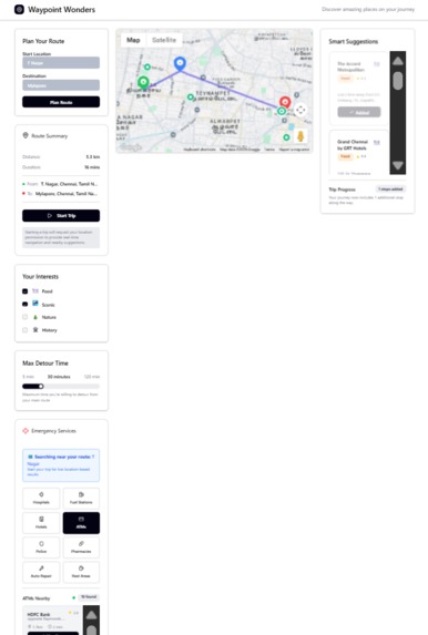
Screenshot of The interface

Inspiration
While navigating a new city like Chennai, we noticed how easy it is to miss out on interesting or essential places simply because they're not visible on a regular route. Whether you're a tourist, a newcomer, or even a local, the journey from point A to point B often overlooks hidden gems and crucial pitstops.
This sparked a thought:
What if your route planner could also be your guide and your safety net?
That’s when Waypoint Wonders was born—a smarter, more human-centric way to explore and travel safely.
What it does
Waypoint Wonders transforms route planning into an enriched experience by allowing users to:
- Discover points of interest like Food, Scenic, Nature, and History along the way.
- Set a detour window from 5 to 120 minutes.
- Get curated suggestions for places that match their interests and are close to their planned route.
- Access a built-in Emergency Services dashboard to find Hospitals, Fuel Stations, Pharmacies, Police Stations, and more in real-time—crucial for travelers in unfamiliar areas.
Whether it's finding a quiet café or a pharmacy during a detour, Waypoint Wonders makes exploration smart and safe.
How we built it
The project combines frontend interactivity with backend intelligence, all powered by Google Maps Platform APIs.
- Frontend: Built in React.js, we used the Maps JavaScript API for route rendering and dynamic POI visualization.
- User Input: Start and end locations, interest filters, and detour duration.
- Backend: Powered by Node.js and Express, the backend handles user input and processes route-related API calls.
- Places API for fetching interest-specific and emergency POIs along the polyline.
- Distance Matrix API to ensure time-bound detour feasibility.
- Emergency Services Engine: A modular interface showing real-time results for hospitals, ATMs, fuel stations, etc., depending on current location or route.
Challenges we ran into
- Filtering relevant POIs efficiently without flooding the user interface.
- Calculating realistic detour times under traffic variability.
- Integrating emergency services while maintaining a clean UX.
- Balancing user control vs smart suggestions—too much data can overwhelm.
Accomplishments that we're proud of
- Seamlessly merging exploration and safety in a single route-planning tool.
- Creating an intuitive UI that feels light yet powerful.
- Successfully integrating multiple APIs while optimizing for speed and accuracy.
- Making a feature that can assist both casual explorers and emergency responders.
What we learned
- Advanced usage of Google Maps APIs like polyline processing, Places queries with biasing, and dynamic response rendering.
- UI/UX design for layered information—keeping it relevant and non-intrusive.
- That true innovation lies in solving real problems with simple interfaces.
What's next for Waypoint Wonders
- Adding voice-based recommendations for hands-free exploration.
- Enabling community-curated POIs for hidden gems.
- Integrating live event pop-ups and time-based offers.
- Collaborating with local businesses and emergency response units for better real-time insights.
- Launching as a Google Maps add-on for travelers, expats, and delivery/logistics users alike.
Built With
- ai
- directionsapi
- distancematrixapi
- express.js
- mapsjavascriptapi
- ml
- node.js
- placesapi
- react.js

Log in or sign up for Devpost to join the conversation.