Lawnalyze: Smart Lawn Care Powered by Satellite + AI
Inspiration
Every day, we walk past massive, lush green school lawns and can't help but wonder: how many thousands of gallons of water are being poured into the dirt just to keep it that way? With California's history of many grueling droughts, water isn't just a resource—it's a precious commodity. We built Lawnalyze to turn that uncertainty into action, giving every homeowner the awareness to stop the waste and start conserving.
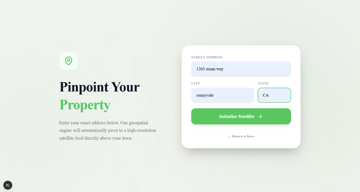
Lawnalyze is an app that lets users input their address and select their lawn to estimate water usage. The idea comes from wanting to combine map-based user input with precise calculations and plant species detection to make sustainable lawn care.
FAQ
Q: Is the hack novel and inventive? Does it take a fresh approach to a real problem? Is it original and unique?
A: Our hack is innovative and original because Lawnalyze is the first tool to integrate map-polygon input, satellite water calculation, AI predicted invasive species ID, and action plans. Existing options are all fragmented, focusing on one of these jobs instead of all of them. Moreover, our app is relatively simple to use compared to existing ones with high technical barriers.
Q: Is the hack practical? Is it something people would actually use? Does it solve a real problem?
A: This hack is highly practical because lawns are something almost everyone is familiar with—whether they own one, visit a park, or see them in their community. Many people don’t realize how much water lawns actually use. Our solution answers that question by providing clear, simple data on water usage for both personal lawns and public spaces. By turning complex environmental data into easy-to-understand insights, it raises awareness and helps people make more sustainable choices about water use.
What it does
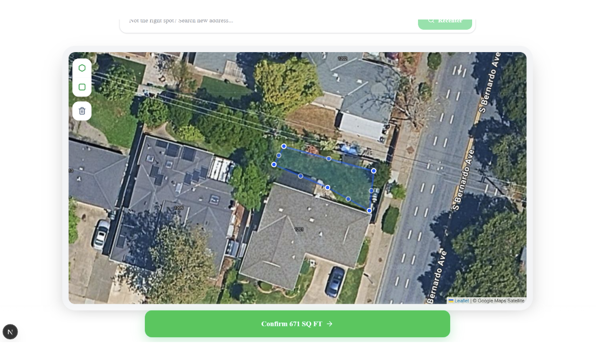
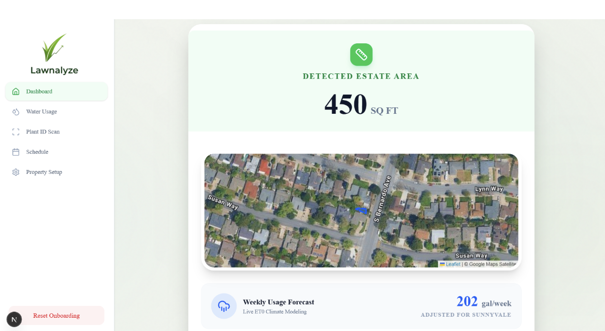
Users input their address and draw one or more polygons directly on the map to outline their exact lawn. Our AI-powered system then:
- Calculates the precise water volume needed using satellite-derived area and local evapotranspiration rates.
- Identifies plants in the lawn so you can notice potential invasive species or finally find out that beautiful flower is a daisy thanks to our app!
- Delivers a personalized action plan for optimal watering.
No more guesswork. Just smarter and greener lawns with less waste and fewer weeds.
How we built it
We developed Lawnalyze as a web app during this hackathon.
- Frontend: Built with Antigravity (coding agent), Whisk for animations, and Stitch for UI.
- Backend: Firebase
- AI & Satellite Integration: Used AI models (via Palantir AIP Platform) for image to species detection and prediction logic from user inputs of plant images. Satellite area calculations leveraged real world data (like scale factor) to make the most accurate predictions possible. When we compared to other websites that specify the square footage of certain areas, our numbers were almost exact.
- Action Plan Generation: Prompt-engineered AI outputs personalized, clear, and step-by-step recommendations.
The core flow: Polygon drawing → Area and water computations; image input → AI predictions. These results lead to a unified dashboard with visuals and smart recommendations.
Challenges we ran into
- When using the Palantir AIP platform to build the AI plant species identifier, we tried both using the media set directly and converting the input image to base-64 strings, but neither worked. Finally, we had to call an action method “Create Plant Images” that creates an object “Plant Images” that contains the property “Image” and then sends this object into the logic function “PlantImageClassifier.”
- Debugging Authentication errors and Connection errors also took significant time. BIG THANKS to George Cooper at Palantir Technologies for his help.
What we learned
This project taught us the power of combining geospatial tools with AI to solve real world environmental problems. We deepened our understanding of using ai-tools and solving challenges we ran through on the way.
Next steps: The next steps we would like to do is add ai chatbot features and not just image detectors.
At the end of the day, Lawnalyze proves that taking care of your lawn can be simple, precise, and actually doable for anyone. We are excited to help create a greener future by building tools like Lawnalyze, one lawn at a time.
Built With
- antigravity
- gemini

Log in or sign up for Devpost to join the conversation.