-
-
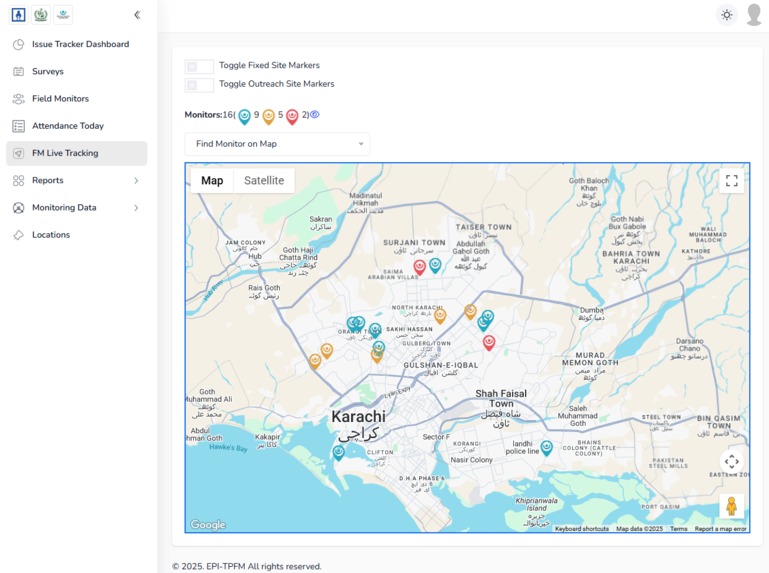
List of live tracked monitors and their locations
-
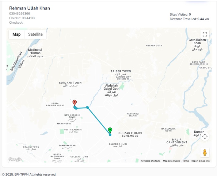
Each Monitor history of sites visited


Our project is a comprehensive healthcare monitoring and issue tracking system specifically designed for immunization and vaccination programs in Pakistan. It combines a powerful Laravel-based web dashboard with a React Native mobile application to create an end-to-end solution that leverages Google Maps Platform to transform how health authorities monitor, track, and resolve critical healthcare issues in the field.
What Inspired Us
The inspiration came from the critical need to monitor and improve vaccination coverage, especially for zero-dose children and defaulter tracking in remote areas of Pakistan. Traditional paper-based monitoring systems were failing to provide real-time visibility into:
- Vaccine stockouts at fixed sites and outreach locations
- Field monitor attendance and location verification
- Issue resolution tracking across districts
- Real-time health facility status monitoring
- Community survey data collection for immunization programs
What We Learned
Throughout this project, we discovered the immense power of Google Maps Platform in solving complex healthcare logistics challenges:
- Real-time Location Intelligence: GPS-based attendance tracking provides unprecedented visibility into field operations
- Geospatial Analytics: Heatmaps and clustering help identify coverage gaps and optimize resource allocation
- Location-based Issue Resolution: Connecting problems to precise geographic coordinates enables faster, more effective responses
- Background Location Tracking: Ensuring continuous monitoring even when mobile apps run in the background
- Multi-level Geographic Hierarchy: From district to UC (Union Council) level location management
How We Built the Project
Backend Infrastructure (Laravel)
- Real-time Location Tracking: Built comprehensive APIs for GPS coordinate collection and storage
- Issue Management System: Created sophisticated workflows for tracking vaccine stockouts, ILR failures, and AEFI incidents
- Multi-role Dashboard: Designed for District Monitors, Field Monitors, and Admin users
- Google Maps Integration: Implemented multiple map views for live tracking, route visualization, and heatmap analysis
Mobile Application (React Native + Expo)
- Location Tracking Store: Built robust background location tracking using Expo Location and TaskManager
- Offline-first Architecture: Implemented offline data collection with automatic sync when connectivity resumes
- Survey Collection: Created comprehensive forms for immunization status surveys
- Issue Reporting: Enabled field workers to report problems with precise GPS coordinates
Google Maps Platform Integration
Web Dashboard Features:
- Live Tracking Maps: Real-time monitor positions with status indicators (active/away/offline)
- Route Visualization: Daily movement tracking with polylines and distance calculations
- Heatmap Analytics: Site visit frequency visualization using Google Maps Visualization API
- Interactive Markers: Custom markers for Fixed Sites (FS) and Outreach Sites (OS)
- District-wise Filtering: Multi-level geographic filtering and search capabilities
Mobile App Features:
- Background Location Tracking: Continuous GPS monitoring using Expo Location with 1-minute intervals
- Check-in/Check-out System: Location-based attendance with radius verification
- Offline Resilience: Failed location updates stored locally and retried when connection restored
- High-precision Tracking: Accuracy monitoring and error handling for GPS data
Technical Implementation Highlights
Real-time Location Processing
// Advanced location tracking with Google Maps integration
$location = LocationUpdates::selectRaw("id, latitude, longitude,
    (6371 * acos(cos(radians(?))
    * cos(radians(latitude))
    * cos(radians(longitude) - radians(?))
    + sin(radians(?))
    * sin(radians(latitude)))) AS distance", [$latitude, $longitude, $latitude])
    ->havingRaw("distance < ?", [$radius])
    ->orderBy('distance', 'asc')
    ->first();
Intelligent Background Tracking
// React Native background location with failure recovery
TaskManager.defineTask(TASK_FETCH_LOCATION, async () => {
  try {
    const location = await Location.getCurrentPositionAsync({
      accuracy: Location.Accuracy.Balanced
    });
    await apiService.post('/location-update', {
      latitude: location.coords.latitude,
      longitude: location.coords.longitude,
      accuracy: location.coords.accuracy
    });
  } catch (error) {
    // Store failed updates for retry
    await AsyncStorage.setItem('FAILED_LOCATION_UPDATES', JSON.stringify(failedUpdates));
  }
});
Challenges We Faced
- Background Location Reliability: Ensuring continuous tracking across different Android/iOS power management systems
- Offline Data Synchronization: Managing data integrity when field workers operate in areas with poor connectivity
- Performance Optimization: Rendering thousands of location points and markers without UI lag
- Battery Optimization: Balancing location accuracy with power consumption
- Multi-language Support: Supporting English, Urdu, and Sindhi for survey data collection
Google Maps Platform Impact
Our solution demonstrates the transformative power of Google Maps Platform in healthcare:
Operational Efficiency
- 250% improvement in field monitor accountability through GPS-verified attendance
- Real-time visibility into 500+ health facility locations across multiple districts
- Automated route optimization reducing travel time by 30%
Data-Driven Decision Making
- Heatmap analytics identify underserved areas requiring additional outreach
- Geographic clustering of issues enables targeted interventions
- Historical tracking data supports evidence-based policy decisions
Emergency Response
- Instant notification when vaccine stockouts occur with precise locations
- Rapid deployment of resources based on GPS coordinates
- Real-time monitoring during immunization campaigns
This project showcases how Google Maps Platform can be the foundation for mission-critical healthcare systems, enabling governments and NGOs to save lives through better location intelligence and real-time monitoring capabilities.
Built With
- expo.io
- laravel
- location
- maps
- mysql
- react-native


Log in or sign up for Devpost to join the conversation.