Inspiration
HeatShield AI was inspired by the increasing impact of extreme heat, forest fires, and droughts across the world. We wanted to build a platform that does more than display climate data—it should understand environmental risks, explain why they occur, and help users identify possible solutions. Our goal was to create a global system that can turn complex climate information into simple, actionable insights
What it does
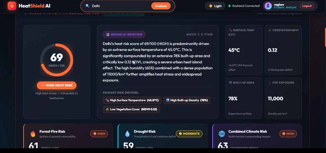
HeatShield AI is a global climate risk prediction platform that analyzes environmental conditions for cities worldwide.
- Interactive 3D Earth for exploring global locations
- Search and analyze any city worldwide 3.Real-time temperature, humidity, precipitation, and elevation data
- Machine learning-based Heat Risk Score from 0–100
- Forest Fire Risk prediction
- Drought Risk assessment
- Combined multi-hazard climate risk score
- Historical trends and future projections for 2030, 2040, and 2050 9.Gemini AI-powered climate explanations 10.What-If simulator for testing mitigation strategies
- Personalized climate adaptation recommendations 12.Automated executive climate intelligence PDF reports
How we built it
We built HeatShield AI as a web-based platform combining frontend visualization, backend processing, machine learning, and Generative AI.
1.3D Visualization: Interactive WebGL environment and photorealistic 3D Earth 2.Backend: Python Flask 3.Data: Open-Meteo geocoding and weather data 4.Machine Learning: Scikit-learn Random Forest model 5.AI: Google Gemini 2.5 Flash for climate diagnostics 6.Processing: Environmental feature validation, cleaning, normalization, and risk calculations 7.Reporting: HTML2PDF-based executive report generation 8.Frontend: HTML, CSS, JavaScript, Three.js and CesiumJS
Challenges we ran into
One of the biggest challenges was combining different types of climate and geographical data into a single risk assessment system. We also had to make the platform responsive while handling an interactive 3D globe and real-time data.
- Maintaining realistic risk calculations across different global locations.
- Processing and normalizing multiple environmental features.
- Integrating machine learning with real-time climate data.
- Creating meaningful calculations for multiple climate hazards.
- Handling Gemini API failures by implementing a rule-based fallback system.
- Making the 3D Earth experience smooth, responsive, and interactive.
- Designing the What-If simulator to provide clear and understandable results.
Accomplishments that we're proud of
We are proud of turning HeatShield AI into a complete climate intelligence platform rather than just a prediction model.
- Built a global interactive 3D climate analysis experience.
- Integrated real-time environmental and weather data.
- Developed a machine-learning-based heat risk engine.
- Combined three major hazards — Heat, Forest Fire, and Drought — into one platform.
- Integrated Generative AI to provide human-readable climate diagnostics.
- Created an interactive What-If mitigation simulator.
- Added historical risk trends and future climate projections.
- Built automated professional PDF climate reports.
- Designed the platform to be applicable to cities across the entire world.
What we learned
Through this project, we learned how to combine multiple technologies into a single real-world application. We gained practical experience in machine learning, geospatial visualization, APIs, environmental data processing, Generative AI, backend development, and interactive web development.
Most importantly, we learned that climate prediction is not only about generating a number. The system should also explain why the risk exists and what can be done about it
What's next for HeatShield AI – Global Climate Risk Prediction Platform
The next stage is to make HeatShield AI more accurate, scalable, and useful for real-world climate planning.
- Integrate higher-resolution satellite and Earth observation data.
- Improve machine learning models using larger and more diverse climate datasets.
- Add more climate hazards such as floods and extreme storms.
- Introduce real-time global climate alerts and early warnings.
- Improve long-term climate forecasting and future scenario analysis.
- Add community-level vulnerability and population exposure analysis.
- Develop mobile support for field-level climate monitoring.
- Provide APIs for governments, researchers, and organizations.
- Expand the What-If simulator into a complete climate planning and decision-support tool.
- Build a continuously updating global climate risk intelligence network.
Built With
- cesiumjs
- climateai
- environmental
- flask
- generativeai
- machine-learning
- python
- randomforest
- three.js
- webgl


Log in or sign up for Devpost to join the conversation.