-
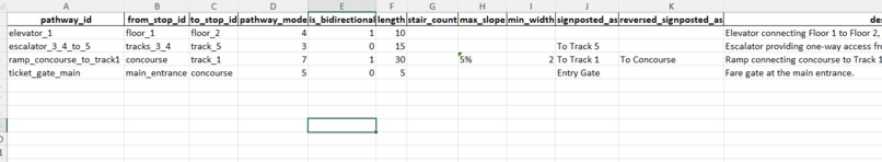
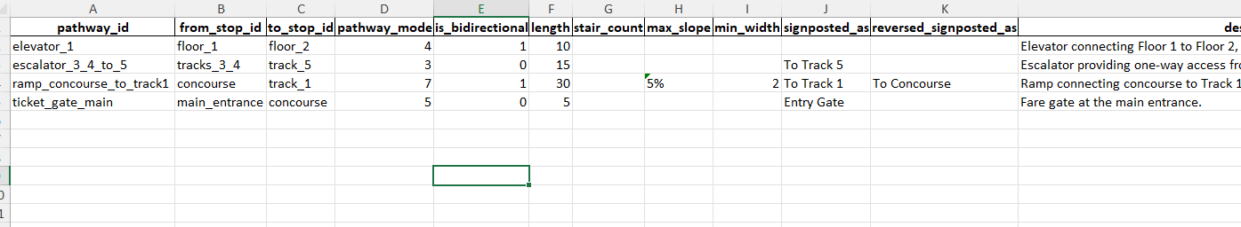
Pathways
-

Stops
-
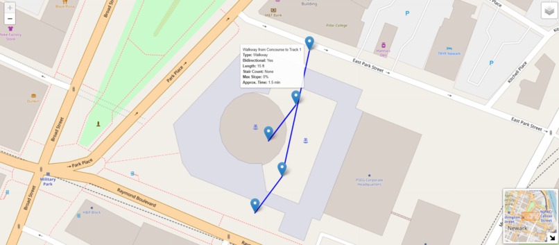
Final Map


Inspiration
The inspiration for this project came from observing the daily complexities of navigating large transit hubs, particularly for people with accessibility needs. We wanted to create a tool that simplifies station layouts using GTFS (General Transit Feed Specification) pathways. Knowing how much of a difference accessible and intuitive station mapping can make, especially for unfamiliar travelers, inspired us to build a more organized data framework for Newark Penn Station.
What it does
The project provides a GTFS-compliant data structure that models stops and pathways within Newark Penn Station. It includes various pathways, such as walkways, ramps, stairs, escalators, and elevators, connecting different floors, tracks, and concourses. This dataset could be used by transit applications to assist commuters, providing accessible routes and easy navigation through complex station layouts.
How we built it
We built this project using Python, specifically with the pandas and openpyxl libraries. We had 4 processes for this project: First, we defined the key elements in stops.txt and pathways.txt, considering details like stop locations, pathway types, inclines, and accessibility Second, we created a GTFSPathwayGenerator class to manage the addition of stops and pathways, with functions to specify length, direction, and bidirectionality Third, To facilitate usage, we implemented methods for saving the data to both CSV and Excel formats, allowing easy integration with transit software. Fourth, we tested the generated files to ensure they adhered to GTFS standards and matched the station layout.
Challenges we ran into
One challenge was converting location data from latitude and longitude to feet for accuracy within the station layout. Additionally, modeling various pathway types (e.g., stairs with step counts, ramps with inclines) added complexity, especially ensuring these specifications fit the GTFS format. Setting up and managing dependencies like openpyxl on the development environment also took time.
Accomplishments that we're proud of
We’re proud of successfully creating a GTFS pathways framework that is both versatile and detailed enough to cover real-world transit navigation needs. Achieving accurate pathway modeling with features like incline, directionality, and stair counts was an accomplishment. The final product is comprehensive and ready to be used in transit applications to enhance accessibility. This was also our first hackathon, so it was an amazing experience being able to make something that works, and is replicable in a larger context.
What we learned
Throughout the project, we learned how to work with GTFS data standards more extensively, especially the less common pathways.txt. We also honed our skills with Python data handling, using pandas for data processing and openpyxl for Excel export. Managing data across different formats and ensuring compatibility with GTFS requirements was a valuable learning experience.
What's next for GTFS Pathway Generator
Next, we aim to integrate this GTFS pathways data with a visualization tool or a real-time transit application to test how it performs in practice. Additionally, expanding the model to cover other transit hubs and adding interactive features, like live navigation and step-by-step guidance for users, would make this tool even more valuable.
Built With
- gtfs
- python

Log in or sign up for Devpost to join the conversation.