-
-

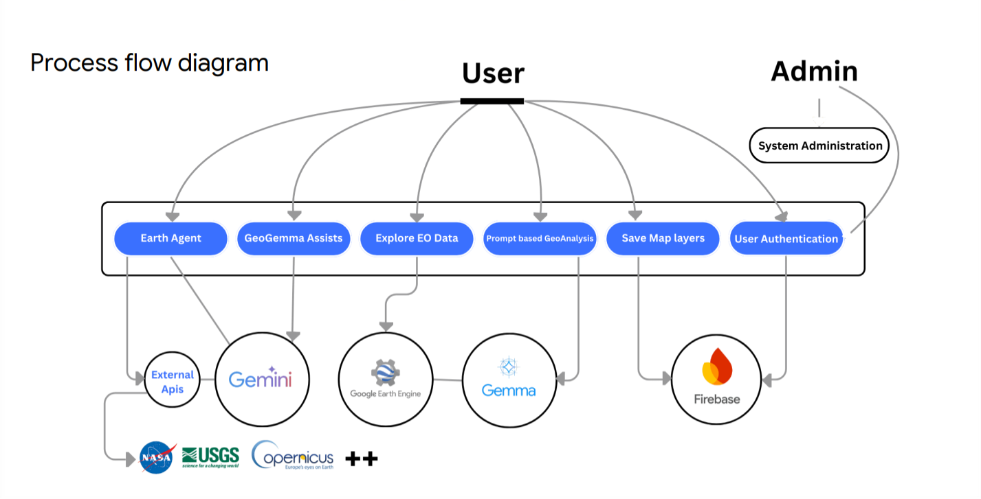
Process Flow Diagram
-
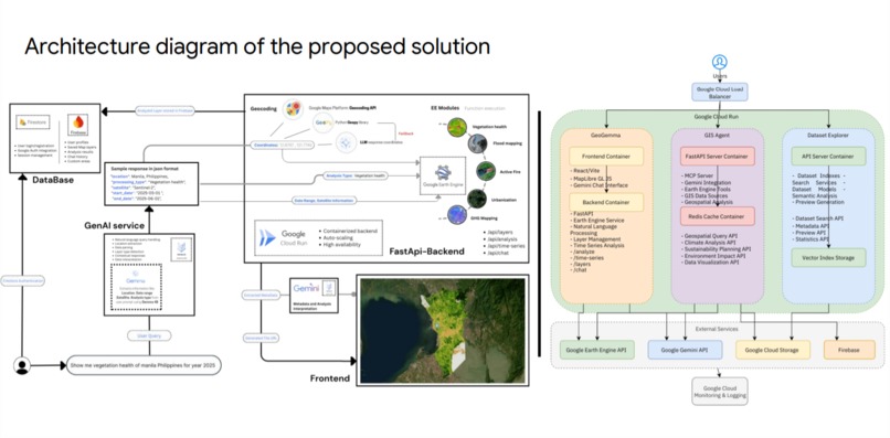
Architecture Diagram
-
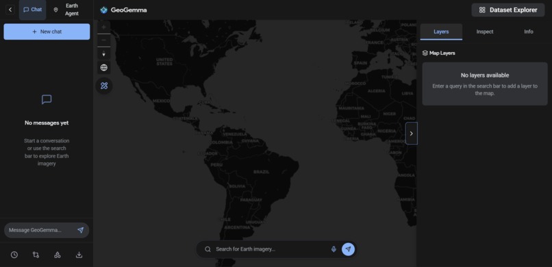
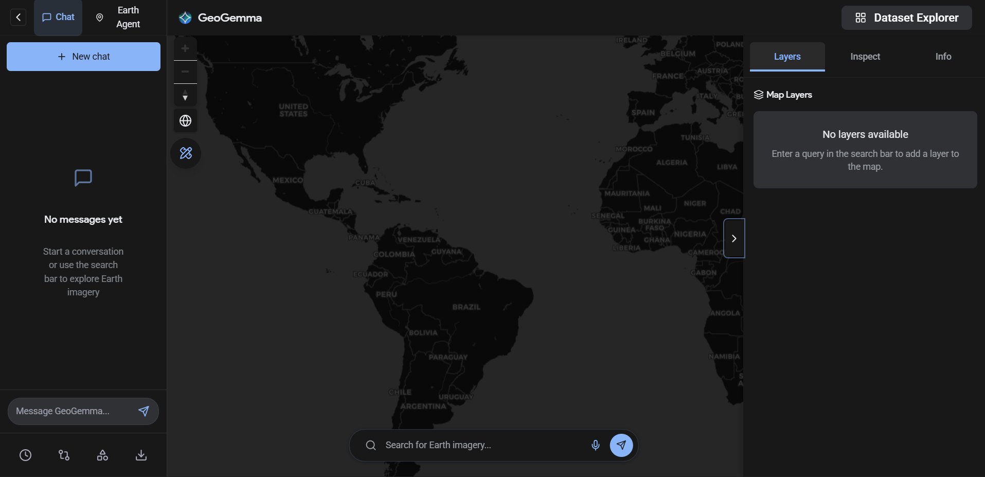
User Interface of the web app
-
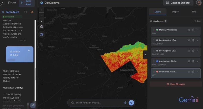
Earth Observation Analysis (Land Surface Temperature of Islamabad) and first geospatial MCP Server
-
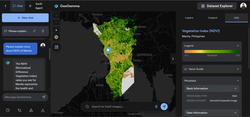
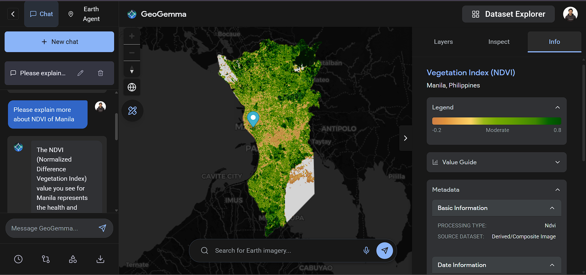
Earth Observation Analysis (Vegetation Index of Manila) and GeoGemma Assist Chatbot
-
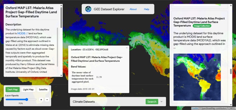
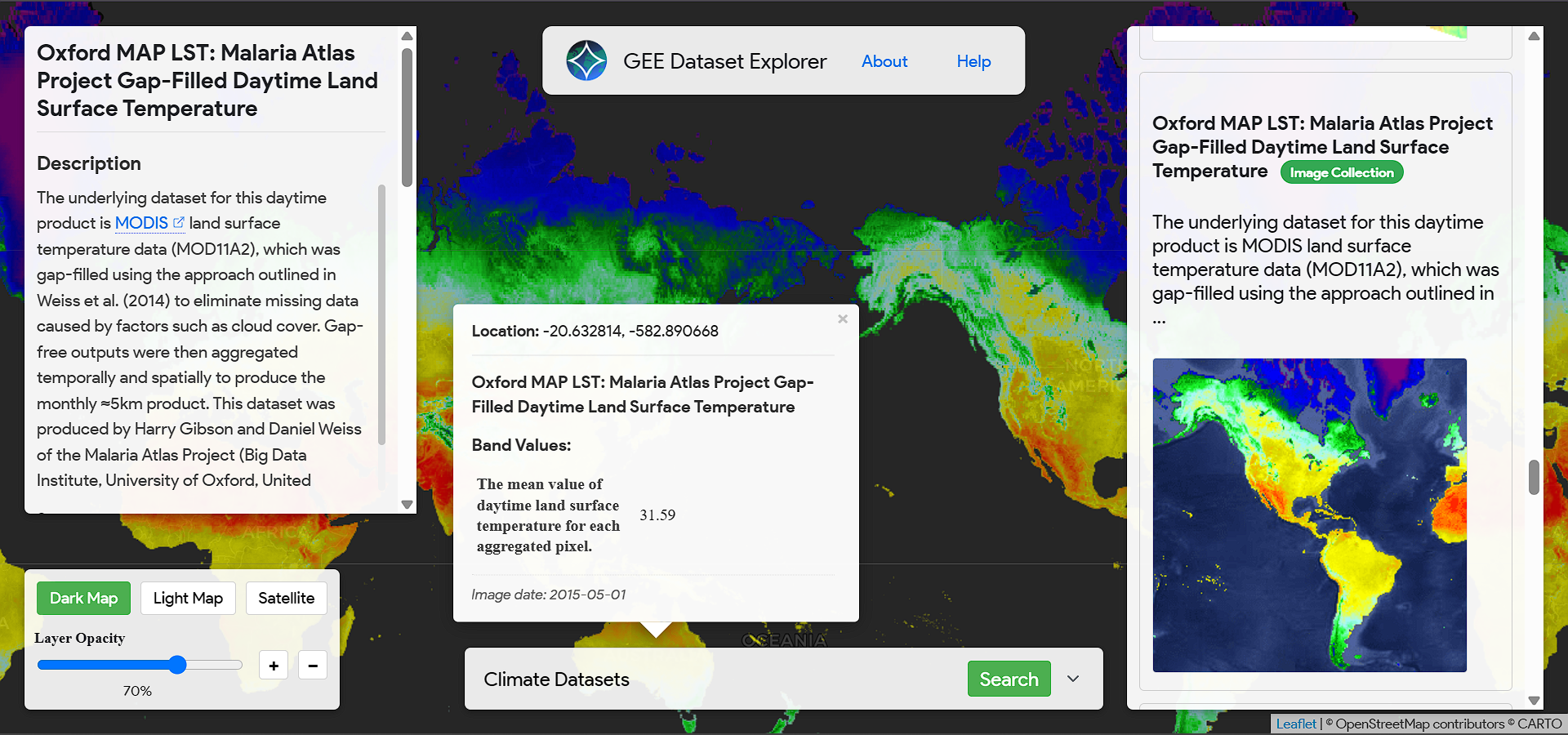
Google Earth Engine Dataset Explorer


Inspiration
Geospatial data is one of the most powerful resources for understanding our planet, but it is also one of the hardest to use. Satellite imagery and Earth observation data require coding skills, domain expertise, and complex tools, which limits access to only a small group of experts. We were inspired to democratize geospatial intelligence by allowing anyone students, researchers, policymakers, and organizations to interact with Earth data using natural language, just like talking to an assistant.
What it does
GeoGemma is an open-source GeoLLM (Geospatial Large Language Model) for Planetary-Scale Satellite Imagery retrieval and Analysis. Therefore, your prompt will jump to any corner of this planet and extract insights powered by the fusion of Gemma and the Google Earth Engine. This enables unprecedented insights of the world around us, from it’s Atmospheric, climatic and Weather data that is updated by the hour. GeoGemma is open source and is aimed to give easier access to active global data to geospatial and non-geospatial users without complex code and hours worth of satellite image processing in an interactive prompt-based Map UI.
How we built it
Gemma / Gemini (LLM layer): reasoning, summarization, and user-facing responses Python (backend): orchestration, data processing, and integration logic LangChain (agent + tools): implemented a ReAct-style agent that can decide when to: call Earth Engine tools, query Firestore / datasets, run retrieval over indexed documents, and then synthesize a final answer RAG pipeline: embeddings + retrieval over project docs, reference data, and user-provided material to ground responses and reduce hallucinations React (frontend): UI for chat, controls, and results panels MapLibre (mapping): interactive maps for viewing layers, AOIs, boundaries, and derived outputs Google Earth Engine: large-scale geospatial computation and dataset access Google Cloud Run: containerized deployment for instant scalability Firebase/Firestore: auth, session state, chat history, user data, and lightweight app storage Local deployment option: Ollama + Gemma for on-device inference when cloud isn’t available or desired
Challenges we ran into
Data quality and format variance: geospatial inputs can be inconsistent (missing coordinates, mismatched projections, messy boundaries). Performance tradeoffs: balancing richer analysis with responsiveness for interactive exploration. Making geospatial concepts approachable: translating GIS-heavy outputs into understandable, action-oriented insights. End-to-end integration: ensuring the processing pipeline, API layer, and UI stayed aligned as the project evolved.
Accomplishments that we're proud of
GeoGemma is a proud Google Funded AI Research. We are utilizing this hackathon to validate this idea to build a commercially viable Product market fit.
A truly end-to-end system: chat → retrieval → geospatial compute → mapped visualization → actionable narrative GeoGemma Chat: Ask geospatial questions in natural language and get grounded answers plus map-ready outputs. Earth Agent: First Geospatial MCP agent that runs Google Earth Engine workflows (pick data, set AOI, compute, return layers/results). It is connected to 10+ apis including NASA, Copernicus, USGS etc Dataset Explorer: Search and preview datasets (metadata + coverage) to quickly choose the right data for analysis. We have utilized 900+ Google Earth Engine Data Catalog all at one place for user easiness. Scalability: Instant scalability via Cloud Run + Firebase/Firestore while retaining a local-first option with Ollama + Gemma An agentic workflow (LangChain ReAct) that can dynamically combine Earth Engine analysis with grounded RAG responses A clean interactive UX using React + MapLibre that makes geospatial AI feel practical and understandable
What we learned
RAG is essential for trust: geospatial outputs need grounding in real datasets, docs, and assumptions. Agent tool design matters as much as the model—clear tool contracts and structured outputs improve reliability. Mapping is communication: presenting results well (layers, legends, summaries) is key to adoption. A hybrid “cloud + local” approach makes the solution more resilient and accessible for real-world constraints.
What's next for GeoGemma
As we gear up for Product Market fit, we aim to scale this AI research into a startup.
Moreover, we aim to further solidify it’s operational capabilities technically.
Expand RAG sources (regional policy docs, local datasets, org knowledge bases) with better citations Add more Earth Engine workflows (change detection, flood/fire risk, land use trends, accessibility/isochrones) Improve observability (tool traces, evaluation sets, quality metrics) for agent decisions Team collaboration features (shared workspaces, saved AOIs, shareable map states) via Firestore Stronger offline workflows and packaging for on-device deployments using Ollama + Gemma
Built With
- firebase
- firestore
- gemini
- gemma
- geocoding-api
- google-cloud
- google-earth-engine
- langchain
- leaflet.js
- python
- react-js

Log in or sign up for Devpost to join the conversation.