-
-

GARUDA
-
-

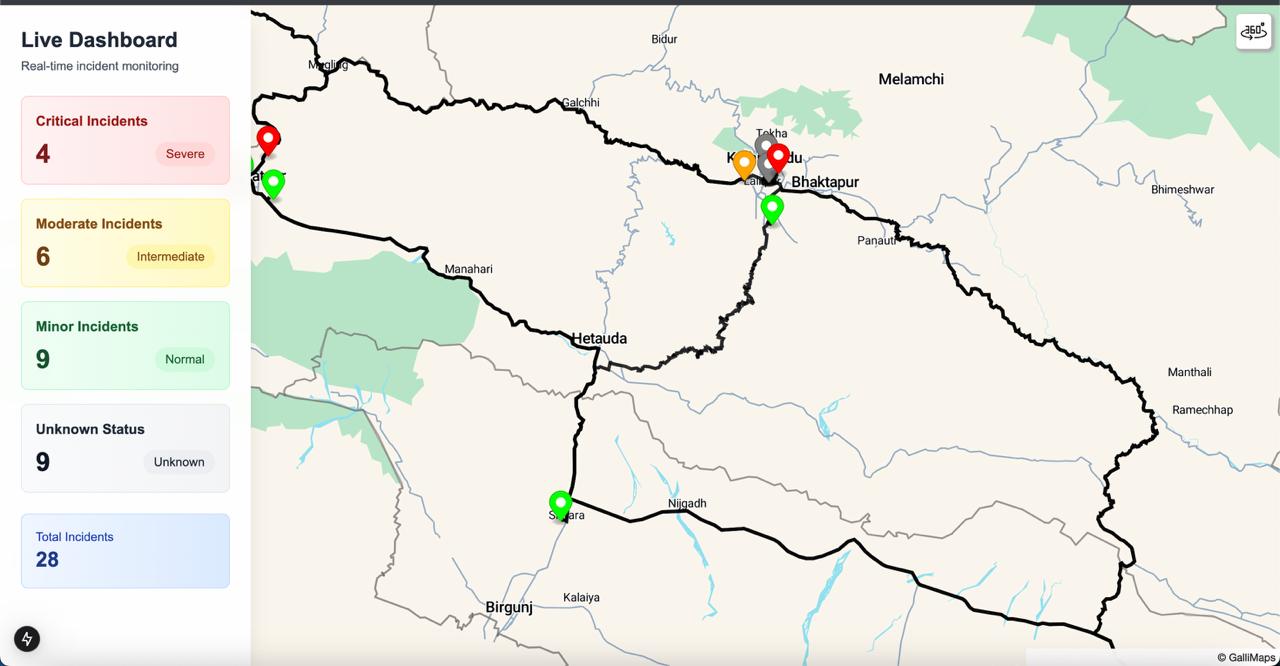
path planning for authorities
-
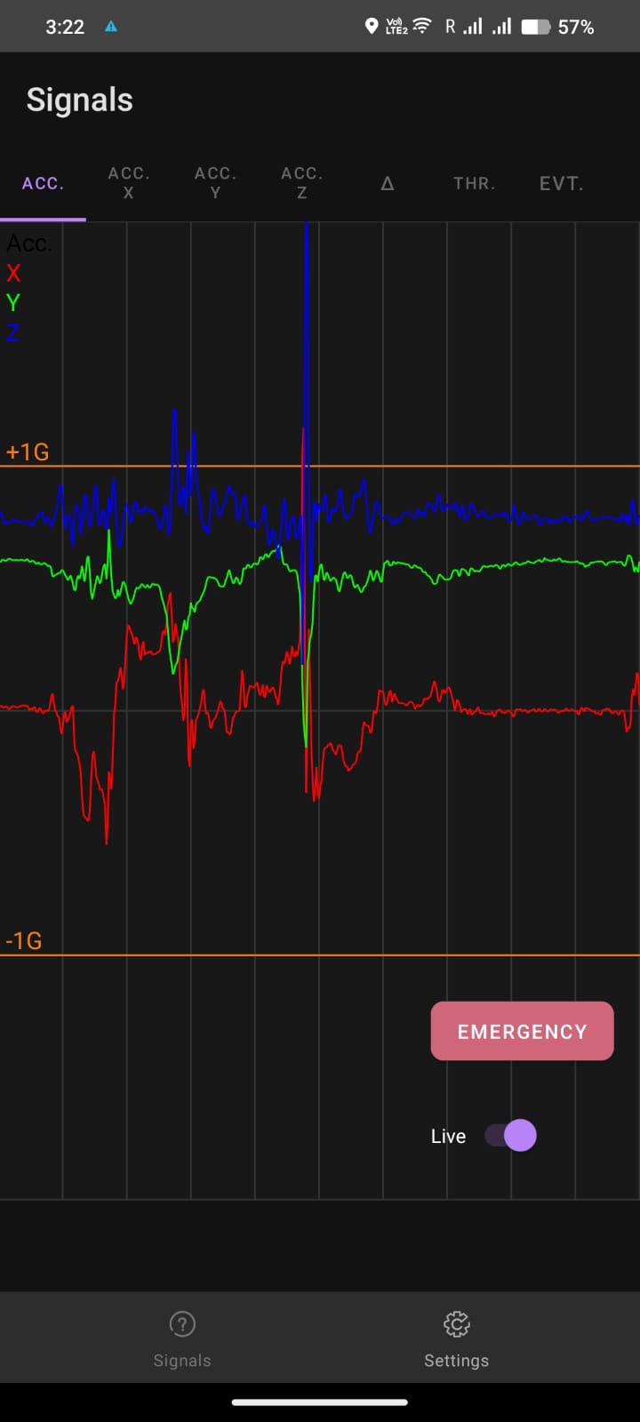
sensations
-
verification
-

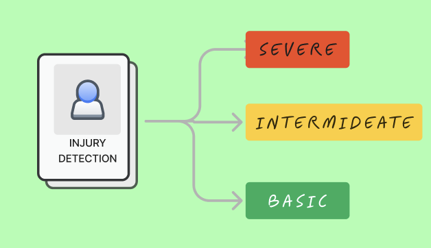
casuality classification

GARUDA: Smart Disaster Response System
Inspiration
The devastating impact of natural disasters and accidents often leaves emergency services overwhelmed and casualties unattended. Inspired by the urgent need for rapid, scalable, and reliable disaster response, we envisioned GARUDA—a solution leveraging smartphones, drones, and AI to provide real-time assistance to affected areas.
Key Inspirations:
- The increasing use of drones in search-and-rescue operations.
- The potential of smartphones as ubiquitous tools for fall detection and emergency alerts.
- A desire to bridge the gap in disaster relief, especially in resource-constrained environments, using innovative and cost-effective technologies.
What It Does
GARUDA is a multi-functional disaster response system designed to detect emergencies and deploy drones for casualty assessment and aid delivery. Here's how it works:
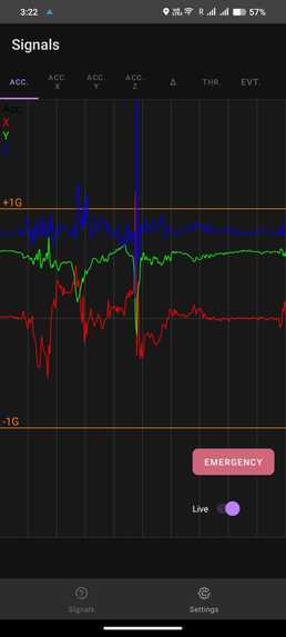
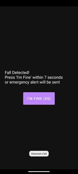
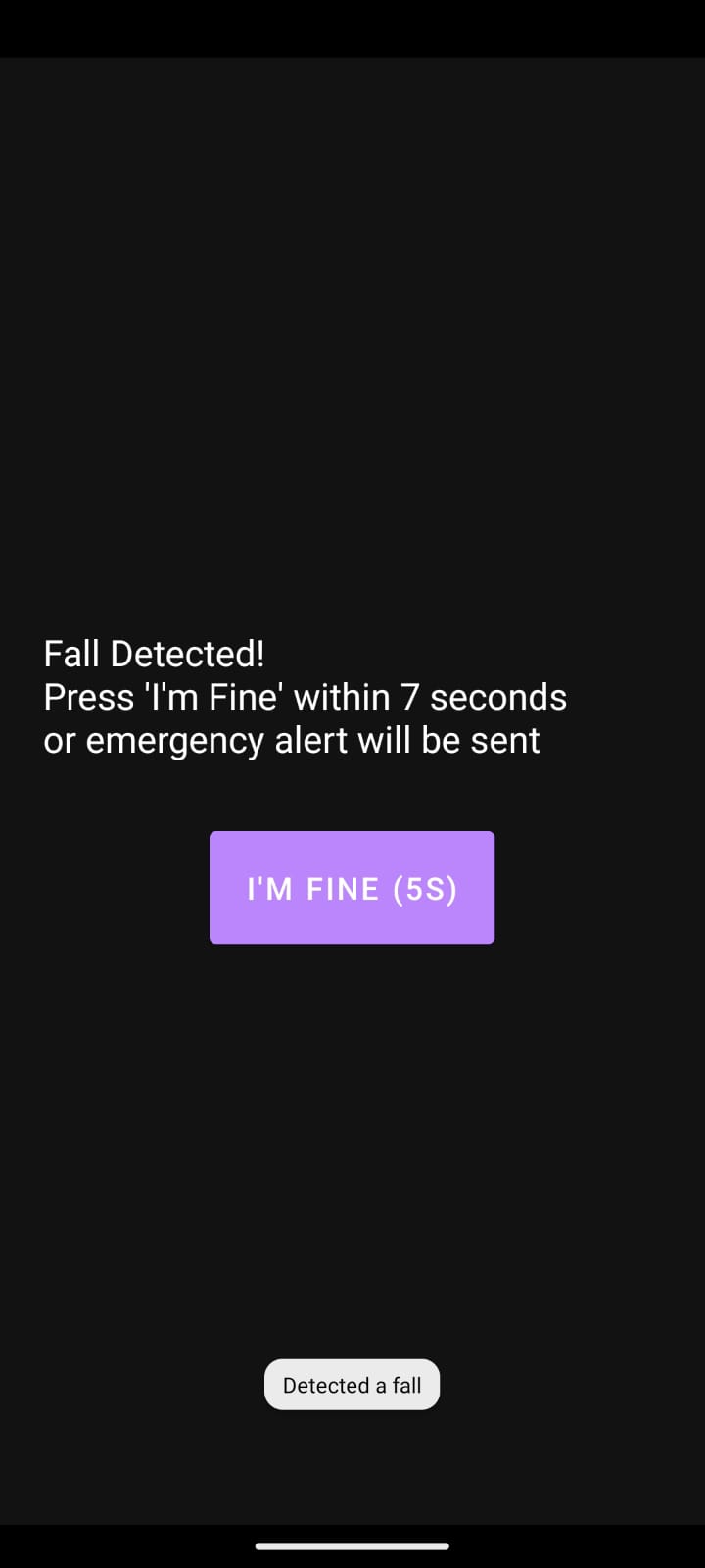
1. Fall Detection
- Uses smartphone accelerometer and gyroscope sensors to detect falls.
- Triggers automated calls and SMS alerts (even offline) to registered emergency numbers with GPS data.
2. Disaster Zone Classification
- Analyzes population density to classify areas as disaster zones based on a 50% threshold.
- Deploys drones if the threshold is exceeded.
3. Drone Deployment
- Drones equipped with thermal imaging and optical flow sensors capture aerial images.
- Identifies casualty locations and transmits data for AI analysis.
4. AI-Driven Casualty Classification
- Classifies casualties into severe, intermediate, and normal categories based on drone imagery.
- Delivers basic medical supplies to normal and intermediate casualties.
5. Real-Time Monitoring
- Provides continuous updates to emergency responders via a centralized platform.
How We Built It
The project was developed in multiple stages:
Fall Detection Module
- Developed using Android SDK to process accelerometer and gyroscope data.
- Machine learning algorithms were implemented to differentiate falls from normal activities.
Disaster Zone Classification
- Population density data was integrated with a custom decision-making system using Python.
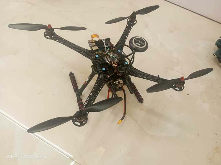
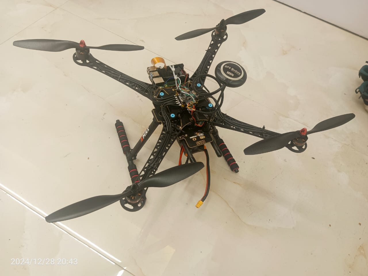
Drone Hardware & Sensors
Drones were equipped with:
- Thermal Cameras: For detecting casualties in poor visibility conditions.
- RGB cameras To ensure every casuality got checked.
AI for Casualty Classification
- Drone-captured images were analyzed using a detr model trained on human detection and to classify casualities we use open ai.
Communication System
- Integrated SMS services for offline alerts.
- Developed a control panel using next.js for real-time monitoring and coordination.
Drone Navigation
- Implemented autonomous navigation using GPS and object avoidance algorithms.
- Tested flight paths in simulated environments.
Challenges We Ran Into
- Sensor Noise: Filtering noisy data from smartphone sensors to improve fall detection accuracy.
- Population Density Thresholds: Determining an optimal threshold for disaster zone classification required extensive testing and calibration.
- Weather Conditions: Ensuring the drone could navigate and capture clear images in adverse weather.
- AI Model Training: Limited availability of labeled human detection data for human detection.
- Real-Time Communication: Achieving low-latency communication between drones, control centers, and responders.
Accomplishments That We're Proud Of
- Successfully integrating offline SMS alerts for emergency situations without internet connectivity.
- Developing a functional prototype of a drone that can navigate autonomously and deliver medical supplies.
- Building an AI model capable of classifying casualties with high accuracy.
- Creating a streamlined workflow combining smartphone sensors, drones, and AI for disaster response.
What We Learned
Technical Insights
- The critical role of thermal imaging.
- How to optimize machine learning algorithms for resource-constrained devices like smartphones.
Collaboration
- Effective teamwork and integration of multiple technologies to solve a complex problem.
- The importance of cross-disciplinary expertise in disaster response projects.
Real-World Impact
- A deeper understanding of the challenges faced by emergency services during disasters.
- The potential of combining AI, IoT, and drones to save lives.
What’s Next for GARUDA
Enhanced Drone Features
- Equip drones with LiDAR for detailed terrain mapping.
- Incorporate swarm technology for coordinated drone operations in larger disaster zones.
Advanced AI Models
- Train AI on more diverse datasets for improved casualty classification.
- Add predictive analytics for better resource allocation during disasters.
Integration with Government Systems
- Collaborate with local authorities and disaster management organizations for real-world deployment.
Mobile App Development
- Create a user-friendly ios mobile for public safety alerts and SOS requests .
Scalability
- Expand GARUDA to support multi-disaster scenarios such as floods, earthquakes, and wildfires.
Community Training
- Provide workshops for responders and community members to operate GARUDA effectively.
Built With
- amazon-web-services
- detr
- kotlin
- mavproxy
- missionplanner
- nextjs
- openai
- prisma
- sitl
- typescript


Log in or sign up for Devpost to join the conversation.